Foundation Problems in Texas: The Two Causes Homeowners Confuse and What Not to Do
In May 2025, a study published in Nature Cities mapped how the ground is moving under the 28 most populous cities in the United States. All of them are sinking to some degree. The fastest rates were found in Texas: Houston, Fort Worth and Dallas averaged more than 4 millimeters per year.
That matters if you own a home, insure one or are about to buy one. Foundation problems in Texas are usually explained with a single cause: clay soil that swells when it rains and shrinks when it dries. That cause is real, but it is only half the story. In large parts of the state, the ground itself is slowly moving downward, and the two problems lead to very different decisions.
This guide explains both causes, the signs that show up in a house, what satellites have measured under Texas cities, and the mistakes that turn a manageable problem into an expensive one.
Why Texas Has Two Kinds of Foundation Problems
Expansive Clay: The Blackland Prairie Problem
According to the Texas Water Development Board, the Houston Black soil series covers about 1.5 million acres of the Blackland Prairie, a belt that runs from north of Dallas toward the south. Soil scientists around the world treat it as the textbook Vertisol: a clay that shrinks and swells markedly as its moisture changes. The Dallas–Fort Worth area, Austin and San Antonio all have large areas of this kind of soil.
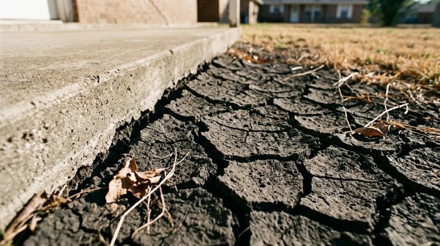
A house built on expansive clay soil rests on ground that changes volume with the weather. During long dry spells the clay loses water and contracts. When heavy rain returns, it expands again. Large trees close to the slab, poor drainage and leaking pipes make that change uneven from one side of the house to the other, and uneven movement is what cracks a structure.
Sinking Ground: The Groundwater Problem
The second problem has nothing to do with rain. When groundwater is pumped out faster than aquifers can recover, clay layers deep below the surface compact and the land above them drops. In the Houston region this is documented over more than a century: since 1906, more than 10 feet of subsidence has occurred, and a broad area of about 6 feet of subsidence covers most of the Houston area today.
Regulation slowed the problem near the coast. The Texas Legislature created the Harris-Galveston Subsidence District in 1975 to control groundwater withdrawals, and the Fort Bend Subsidence District followed in 1989. By 1992, the District had stabilized subsidence in most coastal areas, but rates were increasing in north and west Harris County, which led to stricter regulatory plans for those areas. In other words, the problem did not disappear. It moved with the metro area as it grew west and north.
A University of Houston team using radar data from a European Space Agency satellite measured up to 9 cm of total subsidence to the north, northwest and west of Houston between 2016 and 2020, a rate of about 2 cm per year.
How to Tell Which One Affects Your Home
Only an engineer can confirm the cause for a specific house, but the two problems behave differently, and knowing the difference helps you ask the right questions.
| Expansive clay | Groundwater subsidence | |
|---|---|---|
| Scale | One house or one part of a house | A whole neighborhood or district |
| Driver | Soil moisture: drought, rain, trees, drainage, leaks | Groundwater pumping and compaction at depth |
| Movement | Up and down with wet and dry periods | Slow and steady downward trend over years |
| Main risk | Cracks, sticking doors, uneven floors | Uneven settlement between areas, higher flood exposure |
| Who should assess it | Structural engineer at the property | Engineer plus regional ground movement data |
Signs of Foundation Problems Texas Homeowners Should Not Ignore
The signs of foundation problems look similar whatever the cause. What changes is how you interpret them.
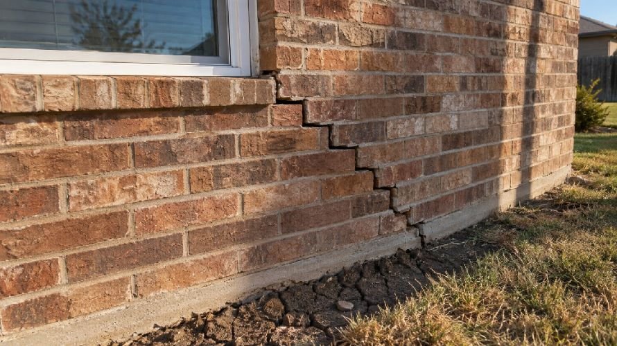
Stair Step Cracks in Brick
Brick and block walls tend to crack along their mortar joints when the ground under one part of the house moves differently from another. The result is a diagonal staircase pattern, often starting at the corners of the house or at the corners of windows and doors. A single hairline crack in mortar is not proof of a structural problem. A crack that keeps growing, or bricks that are no longer aligned on both sides of it, deserves an engineer’s visit.
Doors, Floors and Gaps That Tell a Story
Inside the house, movement shows up as doors and windows that suddenly stick or no longer latch, floors that slope, cracks above door frames, and gaps opening between walls and ceilings or between baseboards and the floor. Each one on its own can have other explanations. Several of them appearing at the same time, on the same side of the house, point to the foundation.
Is My House Sinking, or Is the Whole Neighborhood?
This is the question most homeowners never ask, and it changes everything. Look at the houses around you. If neighbors on the same street are dealing with the same kind of cracks, or if sidewalks, driveways and curbs are tilting in the same direction, the cause may be regional rather than limited to your lot. Movement under a foundation also tends to start well before anyone sees it, which is why it helps to understand how foundation settlement develops before the first crack appears.
What Satellites Have Measured Under Texas Cities
Radar satellites can measure changes in ground height of a few millimeters by comparing images of the same place taken weeks, months and years apart. That makes them the only practical way to see how entire cities are moving, and the results for Texas are hard to ignore.
Houston, Fort Worth and Dallas Lead the Nation
The Nature Cities study, led by researcher Leonard Ohenhen, used satellite measurements collected between 2015 and 2021. Houston came out as the fastest-sinking of the 28 cities: 42% of its land area is sinking at more than 5 mm per year, and 12% at more than 10 mm per year. Scientists generally consider rates above 5 mm per year a significant concern for cities. Across all 28 cities, the researchers associated about 80% of the sinking with groundwater withdrawal.
San Antonio and Austin: Where Uneven Ground Puts Buildings at Risk
Sinking alone is not what damages buildings. The real risk comes when the ground moves at different rates over short distances, so one corner of a structure drops faster than another. The study found that only about 1% of the total land area of the 28 cities lies in zones where this differential movement could affect structures. But the cities with the highest share of buildings in those zones were in Texas: San Antonio, where about 1 in 45 buildings faces high risk, followed by Austin with 1 in 71 and Fort Worth with 1 in 143.
Katy, Cypress and Houston’s Northwest Suburbs
Research focused on the Texas coast, using Sentinel-1 satellite data from 2017 to 2020, found that Katy had the highest subsidence rate in the greater Houston area, at 20 mm per year, mainly as a result of groundwater pumping. The pattern is not new. Earlier work by the U.S. Geological Survey, with satellite radar data from 1993 to 2000, had already mapped an arc of active subsidence running from Spring to Cypress and south to Sugar Land, with rates from 15 mm to more than 60 mm per year.
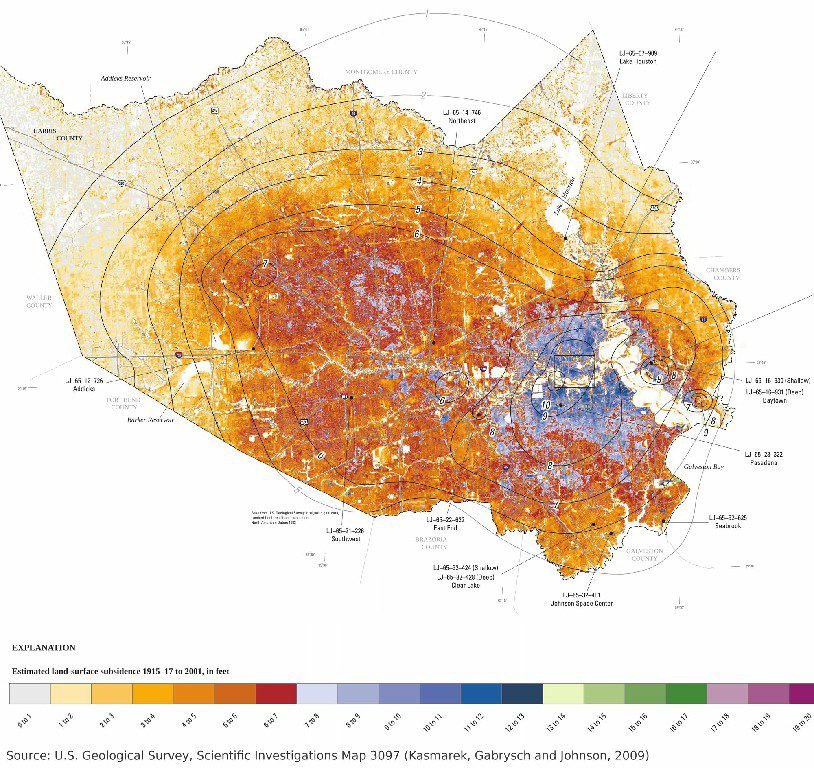
Estimated land subsidence in Harris County, Texas, 1915–17 to 2001. The darkest red and blue areas sank between 6 and 13 feet. Source: U.S. Geological Survey, SIM 3097.
Want to know if the ground under a Texas property has been moving?
SkyIntelGroup analyzes more than a decade of satellite radar data to show how the ground under a home, a neighborhood or a portfolio has moved over time. Send us the address and we will tell you what the data can show.
Brownwood: The Texas Neighborhood That Sank Ten Feet
In 1937, executives of the Humble Oil & Refining Company founded Brownwood, an exclusive waterfront neighborhood in Baytown on the shores of Burnet, Crystal and Scott Bays. For decades it was one of the most desirable addresses in the city.
After Hurricane Carla in 1961, residents began to notice their yards sinking and bay water reaching their backyards. Industrial groundwater pumping in the area had been compacting the ground beneath them. Floods from storms, and eventually from high tides, became part of life in the neighborhood.
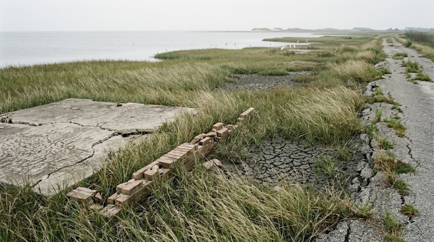
When Hurricane Alicia made landfall in 1983, the subdivision had sunk about ten feet, and the storm destroyed it. More than 300 families lost their homes. The Federal Emergency Management Agency and the City of Baytown bought out the properties, and the land is now the Baytown Nature Center. Old streets serve as trails, and the remains of house foundations can still be seen among the marsh.
The lesson for Texas property owners today is not that every neighborhood will end up like Brownwood. It is that ground movement is slow, silent and easy to ignore until it is no longer reversible. Brownwood residents had no way to measure what was happening under them year by year. That is no longer the case.
5 Mistakes to Avoid When You Find Foundation Problems in Texas
1. Patching Cracks Before Knowing the Cause
Filling a crack with caulk or mortar hides the symptom and erases the evidence. Before anyone patches anything, photograph each crack with a date and a reference for scale. If the crack reopens or grows, that record is worth more than the repair.
2. Assuming Your Insurance Will Pay
In Texas, foundation claims usually turn on one question: what caused the movement. In a 2016 case, a federal judge in Dallas ruled that a homeowner had no coverage for foundation damage linked to plumbing leaks because the policy specifically excluded foundation and earth movement. Years earlier, in the Balandran decision, the Texas Supreme Court had held that the 1991 standard homeowners policy form HO-B did cover foundation movement caused by an underground plumbing leak. Flood insurance has its own limits: the federal flood policy excludes earth movement, including land subsidence, even when a flood triggers it.
Policies differ, so read the exclusions in yours. And keep in mind that whoever can document when and how the ground moved has the stronger position, whether that is the homeowner, the insurer or the court.
3. Paying for a Repair That Doesn’t Match the Cause
Repairs designed for shrink-swell clay deal with movement near the surface of a single property. They do not change what the ground is doing across a neighborhood that is sinking because of groundwater pumping. Before signing a repair contract, ask the engineer which cause the repair is meant to address and what evidence supports that diagnosis.
4. Buying a House Without Checking Its Ground History
Should I buy a house with foundation issues? Many buyers in Texas end up facing that question, and the answer depends on the cause, on whether the movement has stopped and on the cost of a lasting solution. A standard home inspection shows the condition of the house on the day of the visit. It does not show whether the lot, the street or the subdivision has been moving for the past ten years. That history should be part of the decision, especially in areas with known subsidence.
5. Relying on a Single Inspection
One visit gives you a snapshot. Foundation movement is a process that unfolds over seasons and years. An engineer can measure floor levels today, but only repeated measurements, or an existing archive of them, can tell you whether the movement is ongoing, slowing down or accelerating.
How Satellite Data Reveals Years of Ground Movement
More Than a Decade of Radar Archive Over Texas
The European Sentinel-1 radar satellites have been collecting images since Sentinel-1A was launched on April 3, 2014. Sentinel-1B joined in 2016 and stopped working in December 2021. Sentinel-1C was launched on December 5, 2024, and Sentinel-1D in November 2025. Because the satellites revisit the same areas over and over, that archive makes it possible to go back in time and reconstruct how the ground under almost any Texas address has moved, without installing anything on site.
The technique, called InSAR, measures ground and structure movement in millimeters per year. It also has limits that are worth stating clearly. It works best over built-up areas and less well under dense vegetation, and city-wide studies such as the one in Nature Cities map movement on grids of about 90 feet. Satellite data does not replace a structural engineer at the property. It answers the questions an engineer cannot answer in a single visit: since when, how fast and whether the whole area is moving.
Four Questions a Ground Movement History Answers
When foundation problems in Texas reach the point of a repair estimate, an insurance claim or a purchase decision, the useful questions are rarely about the crack itself. They are about the ground:
- Since when? Has the ground been moving for years, or did the movement start recently, for example after a leak or a drought?
- How fast? A few millimeters per year and a few centimeters per year lead to very different decisions.
- Local or regional? Is the movement limited to one lot, or is the whole street or subdivision moving in the same direction?
- Is it changing? Is the movement stable, slowing down after a repair, or accelerating?
A time series built from satellite archives answers all four with dates and measurements, not impressions.
What SkyIntelGroup Delivers for Texas Properties
SkyIntelGroup processes satellite radar archives to produce ground movement histories for a single property, a neighborhood or a full portfolio of assets. In practice, that means:
- Homeowners and buyers: a clear picture of whether the ground under a home has been stable or moving, before spending on repairs or closing a purchase.
- Insurers and adjusters: objective, dated evidence to separate regional ground movement from local causes when evaluating a foundation claim.
- Attorneys: historical measurements that help establish when movement started and how it evolved, as support for expert testimony.
- Foundation repair contractors: regional context that strengthens a diagnosis and helps explain to clients why a specific repair makes sense.
- Developers and property managers: screening of sites and portfolios to identify areas of active movement before building or acquiring.
Our reports are written to be read by the person making the decision, not only by specialists, and they are designed to work alongside the engineer’s on-site assessment.
Get a ground movement history for your Texas property
Tell us the address or the area you want to evaluate. We will review the available satellite data and explain what it can show before you commit to anything.
Frequently Asked Questions
Are foundation problems common in Texas?
Yes. Large parts of the state sit on highly expansive clay, including the Blackland Prairie around Dallas, Fort Worth, Austin and San Antonio, and several Texas cities show some of the highest ground subsidence rates measured in the United States.
Does homeowners insurance cover foundation damage in Texas?
It depends on the policy and on the cause. Many policies exclude settling and earth movement, while some damage linked to sudden events such as plumbing leaks has been covered under certain policy forms. Read your exclusions and document the cause.
Can satellites detect movement under a single house?
Satellite radar measures movement in millimeters per year over ground points and structures, which shows whether a home’s surroundings have been stable or moving. For a structural diagnosis of one building, it should be combined with an engineer’s inspection.
Should I buy a house with foundation issues in Texas?
Only after you know the cause, whether the movement is still active and what a lasting fix would cost. Ask for an engineer’s report and check the ground movement history of the area before you close.
Sources: Ohenhen et al., Nature Cities (2025); University of Houston (2022); U.S. Geological Survey; Harris-Galveston Subsidence District; Texas Water Development Board; Texas Department of Insurance; Federal Emergency Management Agency; European Space Agency.