Wildfire Detection: How Satellite Constellations Spot Forest Fires in Under 30 Minutes [2026]
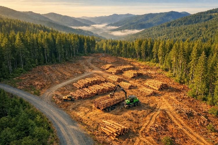
Forest fires now burn twice as much tree cover globally as they did just twenty years ago. In the United States alone, wildfires generate between $394 billion and $893 billion in annual economic damage, equivalent to 2-4% of the nation’s entire GDP. The January 2025 Los Angeles wildfires provided a devastating reminder of what happens when detection comes too late: over $250 billion in total economic losses, entire neighborhoods reduced to ash, and communities forever changed. Yet the technology to detect fires when they are still the size of a classroom now exists. Purpose-built satellite constellations equipped with thermal infrared fire detection sensors can identify ignitions within minutes and deliver alerts before flames grow beyond control. The question facing forest managers, timber companies, insurance providers, and government agencies is no longer whether early wildfire detection systems work. The question is how quickly organizations will adopt the satellite wildfire monitoring intelligence that could prevent the next megafire.
At SkyIntelGroup, we deliver the geospatial intelligence that transforms raw satellite data into actionable wildfire alerts and fire risk assessment insights. Our approach integrates multiple sensor types, advanced analytics, and expert interpretation to provide forest operations with the situational awareness they need to protect assets worth millions and respond decisively when every minute counts. This guide examines how modern wildfire detection technology works, compares the capabilities of current satellite systems, and explains how organizations can implement real-time fire monitoring strategies that fundamentally change their relationship with wildfire risk.
Why Traditional Wildfire Detection Falls Short in 2026
The Lookout Tower Problem
For more than a century, wildfire detection relied on human observers stationed in remote towers, aerial patrols flying predetermined routes, and public reports through emergency phone systems. These methods served their purpose when fires burned smaller and slower, but they cannot keep pace with the megafires that now define wildfire seasons across multiple continents. Detection delays of eight to twelve hours remain common in legacy systems, while modern satellite wildfire monitoring platforms can identify ignitions in minutes. The geographic limitations compound the problem: human observers cannot see beyond ridgelines, aerial patrols cannot fly at night or through heavy smoke, and remote forests may be hours from the nearest inhabited area where someone might notice and report flames.
The afternoon and evening hours present particular challenges. Fires burn hottest and spread fastest during these periods, yet traditional detection methods often provide the least coverage precisely when risk peaks. Lookout towers typically operate during daylight hours with limited staff. Aerial reconnaissance flights follow schedules constrained by pilot availability and aircraft costs. Meanwhile, satellite constellations circle the Earth continuously, their thermal infrared fire detection sensors operating regardless of time, weather, or the presence of smoke that would blind human observers.
The Cost of Every Lost Minute
Fire behavior experts quantify the stakes with a simple observation: under extreme conditions with dry fuels and high winds, wildfires can spread at speeds exceeding 25 kilometers per hour. The firefighting community captures this reality with an adage that has guided their profession for generations: you fight fire in the first second with a spoon of water, in the first minute with a bucket, and in the first hour with a truckload. Every minute of detection delay translates directly into expanded fire perimeters, increased suppression costs, and greater risk to lives and property.
A 2025 field deployment in Colorado demonstrated the concrete value of early wildfire detection systems. Ground-based sensors detected a reignition at a controlled burn site and generated an alert that reached emergency management officials 37 minutes before the first 911 call arrived. That 37-minute head start allowed firefighters to contain what could have become a significant wildfire while it remained manageable. Scale that advantage across thousands of potential ignitions each fire season, and the cumulative impact on suppression costs, property losses, and carbon emissions becomes substantial.
How Satellite Wildfire Detection Technology Works
Thermal Infrared Sensing — Seeing Heat Through Smoke
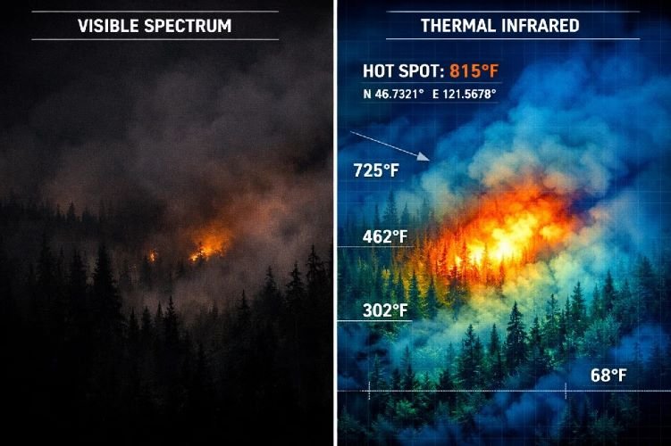
The physics that enable satellite wildfire monitoring rely on a fundamental property of electromagnetic radiation: hot objects emit energy at predictable wavelengths that specialized sensors can detect from orbit. Modern fire detection satellites carry instruments sensitive to mid-wave infrared (MWIR) and long-wave infrared (LWIR) radiation. MWIR sensors excel at identifying high-temperature flames that emit strongly in the 3-5 micrometer wavelength range. LWIR sensors operating in the 8-14 micrometer range detect lower-temperature heat sources, including smoldering fires that may not yet produce visible flames but represent significant ignition risk.
This thermal infrared fire detection capability provides advantages that visible-light imagery cannot match. Infrared radiation passes through smoke that would completely obscure optical sensors. Night operations require no illumination since the sensors detect emitted heat rather than reflected light. Cloud cover presents challenges, but certain wavelengths can penetrate thin cloud layers, and the rapid revisit rates of modern constellations mean that any given location receives multiple observation opportunities each day. Beyond simple detection, thermal sensors measure Fire Radiative Power (FRP), a metric that quantifies fire intensity and helps incident commanders understand whether they face a low-intensity surface fire or a high-intensity crown fire requiring different suppression strategies.
From Raw Imagery to Actionable Alerts
The satellites themselves represent only one component of an effective wildfire detection technology system. Raw thermal imagery requires processing to distinguish actual fires from false positives including industrial heat sources, sun-heated surfaces, and volcanic activity. Modern constellations address this challenge by running artificial intelligence algorithms directly onboard the spacecraft. These onboard processors analyze thermal anomalies in real time, compare current observations against historical baselines for each location, and filter out signatures that do not match fire behavior patterns.
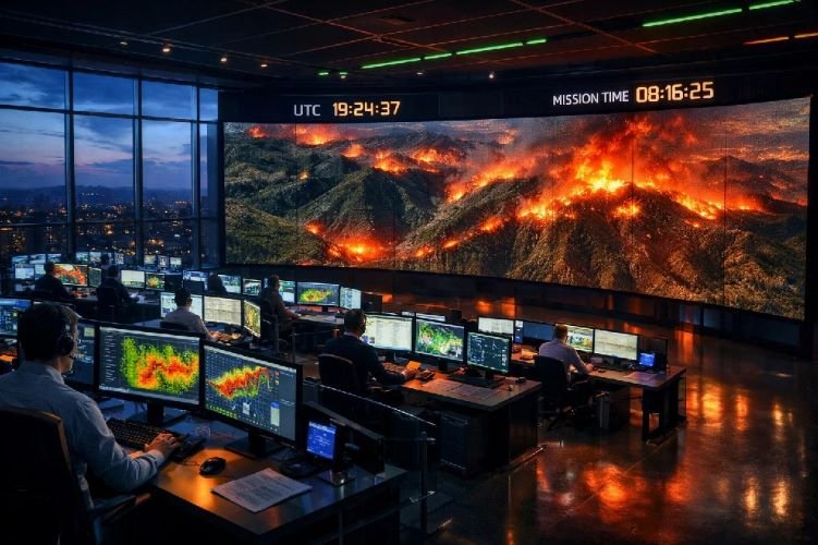
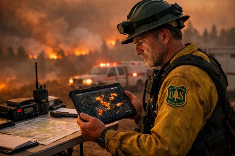
When the system identifies a likely fire, alert generation follows within minutes rather than hours. Emergency managers receive notifications through multiple channels including SMS, email, mobile applications, and direct API integration with existing incident command systems. The alerts include geographic coordinates precise enough to direct ground crews or aircraft to the ignition point, along with contextual information about fire intensity and nearby infrastructure or populated areas. GIS-ready outputs allow immediate integration with mapping platforms that firefighting agencies already use, eliminating the friction that historically delayed satellite data reaching decision-makers in the field.
| Parameter | Traditional Detection | Satellite Detection |
|---|---|---|
| Detection Time | 8–12 hours average | 10–30 minutes |
| Coverage Area | Limited to tower sightlines | Entire forest estate |
| Night Operations | Severely limited | Full capability |
| Smoke Penetration | Cannot see through smoke | Thermal IR penetrates smoke |
| Scalability | Requires additional infrastructure | Instant expansion to new areas |
Comparing Current Satellite Systems for Wildfire Detection
Legacy Systems — MODIS and VIIRS
The Moderate Resolution Imaging Spectroradiometer (MODIS) instruments aboard NASA’s Terra and Aqua satellites have provided fire detection data since the early 2000s, establishing the foundation for satellite wildfire monitoring as an operational discipline. MODIS offers 1-kilometer resolution thermal detection with global coverage every one to two days. The system can detect fires as small as approximately 30 by 30 meters under optimal conditions, though its coarse resolution means that precise fire perimeter mapping requires supplemental data sources. Importantly, Terra is approaching end of life with data acquisition expected to cease around fiscal year 2027, while Aqua faces similar constraints around fiscal year 2026.
The Visible Infrared Imaging Radiometer Suite (VIIRS) aboard NOAA-20 and Suomi NPP satellites represents an evolution in capability. With 375-meter resolution, VIIRS detects smaller fires and maps perimeters with greater fidelity than MODIS while maintaining similar global coverage timelines. Improved nighttime performance makes VIIRS particularly valuable for monitoring fires during the hours when they often burn most intensely. NASA’s Fire Information for Resource Management System (FIRMS) integrates data from both MODIS and VIIRS to provide near-real-time fire detection accessible to agencies and the public. These legacy systems remain responsible for over 95% of large wildfire detections in the United States and Canada, but they were designed for general Earth observation rather than dedicated fire monitoring.
The New Generation — FireSat and OroraTech
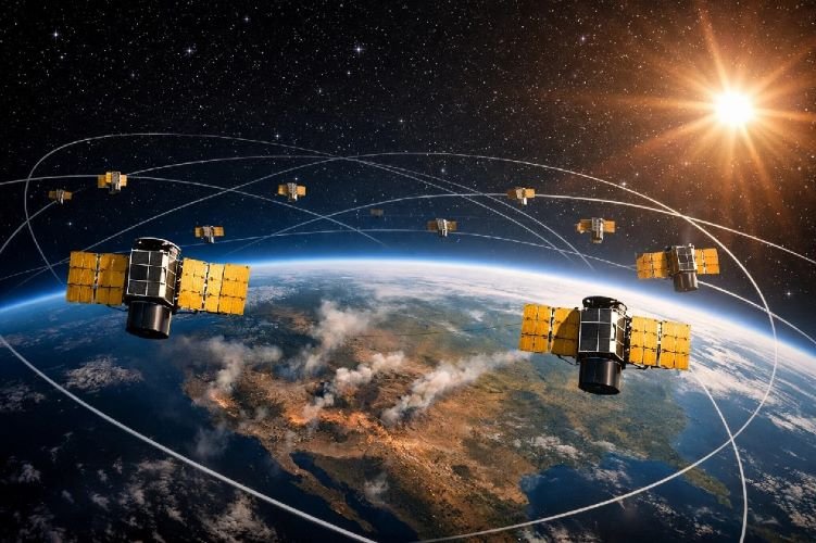
Purpose-built fire detection constellations now entering operation represent a fundamental advancement in early wildfire detection systems capability. FireSat, a collaboration between the Earth Fire Alliance, Muon Space, and Google Research, launched its prototype satellite in March 2025. The system demonstrated detection of fires as small as 5 by 5 meters, roughly the size of a classroom, with thermal sensitivity that identified an Oregon wildfire missed by existing satellite systems. When the full constellation of approximately 50 satellites reaches operational status by 2030, FireSat will monitor every point on Earth every 20 minutes, a revisit rate selected based on extensive consultation with fire agencies who identified this interval as the threshold for materially improving suppression outcomes. TIME magazine recognized FireSat among its Best Inventions of 2025.
OroraTech, headquartered in Germany, launched eight satellites in March 2025 as Phase 1 of a constellation planned to exceed 100 satellites by 2028. The system achieves 4 by 4 meter detection through AI-enhanced processing of 200-meter native resolution imagery, with alert latency under 10 minutes from observation to notification delivery. OroraTech specifically addresses the afternoon detection gap, providing thermal coverage during the critical hours when fires burn hottest and existing public satellites offer limited observations. Integration with MeteoSat-12, a geostationary satellite providing 10-minute scan intervals over Europe, Africa, and South America, further closes temporal gaps in coverage.
Pre-Fire Risk Assessment with Satellite Intelligence
Vegetation Fuel Load Mapping
Effective fire risk assessment begins long before ignition occurs. Satellite imagery enables continuous monitoring of the vegetation conditions that determine how readily fires start and how intensely they burn once established. The Normalized Difference Vegetation Index (NDVI) derived from multispectral imagery tracks plant health and vigor across entire forest estates. Declining NDVI values over time indicate stressed vegetation with reduced moisture content, precisely the conditions that transform routine ignition sources into rapidly spreading fires. Historical NDVI time series spanning multiple years reveal which areas consistently dry out earliest in fire season and which maintain relative resilience.
Beyond vegetation health indices, modern satellite systems estimate structural characteristics that influence fire behavior. Stereo imagery from high-resolution optical satellites generates three-dimensional models of forest canopy, identifying areas where dense crowns create continuous fuel pathways that support crown fire spread. LiDAR data, increasingly available from both airborne and satellite platforms, provides even more precise measurements of canopy height, understory density, and ladder fuel presence. When combined with topographic analysis identifying slopes and aspects that accelerate fire spread, this forest fire satellite imagery analysis produces comprehensive fuel load maps that guide both prevention investments and suppression planning.
Fire Weather Integration
Vegetation conditions alone do not determine fire risk. Weather variables including temperature, humidity, wind speed, and precipitation history interact with fuel conditions to create the moments of extreme danger when ignitions become difficult or impossible to control. Modern wildfire detection technology platforms integrate satellite-derived vegetation data with meteorological models to generate dynamic risk assessments that update as conditions change. Soil moisture indices derived from radar satellites indicate how completely fuels have dried following precipitation events. Evapotranspiration estimates track the rate at which vegetation loses moisture to the atmosphere.
Predictive capabilities now extend to fire spread simulation. Given current vegetation conditions, topography, and forecast weather, algorithms model how a hypothetical ignition would propagate over the following one, three, and six hours. These simulations identify locations where an ignition occurring under forecast conditions would threaten critical assets including populated areas, utility infrastructure, and high-value timber stands. For utilities operating transmission lines through fire-prone landscapes, this intelligence enables proactive decisions about public safety power shutoffs before dangerous conditions develop rather than reactive shutoffs after fires already threaten infrastructure.
SkyIntelGroup Fire Risk Assessment Workflow
How SkyIntelGroup Delivers Wildfire Intelligence for Forest Operations
Multi-Sensor Integration for Comprehensive Monitoring
Effective real-time fire monitoring requires more than access to a single data source. Different satellite sensors provide complementary information, and the integration of multiple data streams produces insights that no individual source can match. Our approach at SkyIntelGroup combines optical imagery from Sentinel-2 and commercial providers to establish vegetation health baselines and detect changes in forest condition. Synthetic Aperture Radar (SAR) from Sentinel-1 provides all-weather observation capability, penetrating the clouds and smoke that render optical systems blind during precisely the conditions when fires often spread most rapidly. Thermal data integration, drawing on both publicly available sources and commercial partnerships, enables active fire detection with the response times modern fire management demands.
We configure monitoring systems to match each client’s specific operational requirements and risk tolerance. A timber company managing high-value plantation forests may require different alert thresholds than a conservation organization monitoring a wilderness area where some fire plays an ecological role. Utility operators need integration with their existing outage management and public safety systems. Carbon credit developers require documentation that supports verification under voluntary market standards. The underlying satellite data remains consistent, but our interpretation, alert configuration, and deliverable formats adapt to serve each client’s decision-making needs.
From Detection to Decision — Actionable Deliverables
Raw data without interpretation creates burden rather than value. Our team translates satellite observations into deliverables that drive operational decisions. Daily and weekly risk reports identify areas where vegetation conditions and weather forecasts create elevated ignition probability, enabling proactive deployment of detection resources and pre-positioning of suppression assets. When our systems detect active fires, alerts reach client operations centers through their preferred channels within minutes, including the geographic coordinates, estimated fire intensity, and contextual information about nearby assets that incident commanders need to prioritize response.
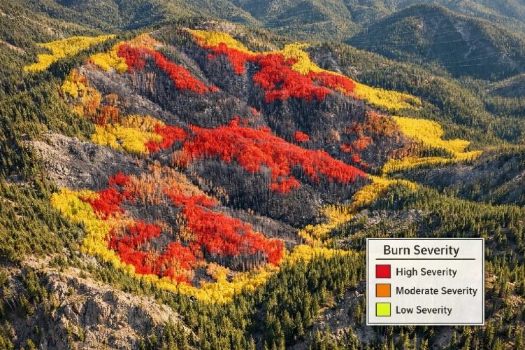
Post-fire analysis applies burned area mapping techniques using the differenced Normalized Burn Ratio (dNBR) to classify burn severity across the affected landscape. This classification distinguishes areas where fire killed all vegetation from areas experiencing moderate damage where recovery will proceed more rapidly. For clients with insured assets, our timestamped, georeferenced imagery provides evidence supporting claims documentation. For forest carbon credit projects operating under REDD+ or voluntary market standards, we estimate carbon stock losses and provide the monitoring data that verification bodies require to assess project performance following fire events.
Protect Your Forest Assets with Satellite Intelligence
Our wildfire detection and monitoring solutions deliver the early warning capability that gives your team the critical minutes needed to respond effectively.
Post-Fire Damage Assessment and Recovery Monitoring
Burned Area Mapping with Satellite Imagery
When fires do occur despite prevention efforts, rapid and accurate damage assessment enables effective recovery planning. Burned area mapping using satellite imagery provides comprehensive coverage that ground surveys cannot match, particularly in rugged terrain where access remains limited even after active fire suppression concludes. The differenced Normalized Burn Ratio (dNBR) compares pre-fire and post-fire imagery to classify burn severity across the entire affected area. High-severity zones where fire consumed all above-ground vegetation require different management than moderate-severity areas where some live vegetation survived and will contribute to natural regeneration.
Precision in area calculation matters for multiple stakeholders. Timber companies need accurate estimates of lost merchantable volume to inform insurance claims and revise harvest schedules. Conservation organizations require perimeter and severity data to prioritize post-fire restoration investments. Government agencies managing public lands need rapid damage assessments to support emergency funding requests and inform public communication. Satellite-derived burned area mapping delivers hectare-level precision within days of fire containment, compared to the weeks or months required for comprehensive ground-based surveys.
Tracking Forest Regeneration
The relationship between forest managers and fire does not end when flames are extinguished. Recovery monitoring using satellite imagery tracks vegetation response over months and years following fire events. NDVI time series document the trajectory of regeneration, identifying areas where natural recovery proceeds on schedule and areas where intervention may be necessary to prevent conversion to non-forest land cover. Some fire-adapted ecosystems regenerate rapidly from surviving root systems and seed banks. Others require active reforestation to prevent erosion, restore wildlife habitat, and reestablish carbon sequestration capacity.
For carbon credit projects, recovery monitoring takes on particular importance. Fire-induced carbon losses must be documented under registry protocols, and projects typically face buffer pool deductions or require compensating actions to maintain credit validity. Long-term monitoring demonstrates whether forest carbon stocks are recovering toward pre-fire levels or whether permanent carbon losses have occurred that affect project accounting. Our analysis integrates field verification with satellite observations to provide the evidence that verification bodies require while minimizing the cost of ground-based sampling campaigns.
The ROI of Satellite-Based Wildfire Detection
Quantified Savings from Early Detection
The economic case for satellite wildfire monitoring rests on straightforward mathematics: smaller fires cost less to suppress and cause less damage. Analysis of the FireSat constellation projects that achieving one-hour revisit rates across the United States would prevent over $1 billion in annual fire damage while reducing carbon emissions by 21.9 million tons through faster containment that limits total area burned. These figures reflect only the direct benefits of reduced fire size; they do not capture the avoided losses to timber value, watershed function, wildlife habitat, air quality, and community wellbeing that accompany smaller fire footprints.
Suppression cost savings compound the value proposition. A fire contained at 10 hectares requires dramatically fewer resources than the same ignition allowed to expand to 1,000 hectares before detection. Aircraft costs, firefighter deployment, equipment positioning, and incident management overhead all scale with fire complexity. Early detection enables what fire professionals describe as initial attack success, containing fires during the first operational period before they establish the size and intensity that require extended campaign-level response. Investment in detection technology that improves initial attack success rates pays returns across every subsequent link in the fire management chain.
Protecting High-Value Forest Assets
Beyond suppression cost avoidance, early wildfire detection systems protect asset values that dwarf monitoring investments. Commercial timber operations manage forest estates worth hundreds of millions of dollars, where a single uncontrolled fire can destroy years of growth and decades of management investment. The arithmetic is simple: if satellite monitoring costs represent a small fraction of one percent of asset value annually, preventing even one significant fire loss over a multi-decade forest rotation generates returns that justify the monitoring investment many times over.
Carbon credit projects face particularly acute fire risk. Projects registered under REDD+ or voluntary market standards hold carbon stocks that translate directly to financial value. Fire-induced carbon losses trigger buffer pool deductions, potential credit invalidation, and reputational consequences that affect future project development. Satellite monitoring that protects these carbon assets from fire simultaneously protects the revenue streams and environmental outcomes that motivated project investment. Insurance providers increasingly recognize proactive monitoring as a risk management factor that can influence premium calculations, creating additional financial benefit for forest operators who demonstrate sophisticated fire risk assessment capabilities.
Case Studies in Satellite Wildfire Detection
FireSat Oregon Detection — Catching What Others Missed
In July 2025, the FireSat prototype satellite detected a small roadside fire in Oregon that existing satellite systems failed to identify. The fire was relatively cool and compact, precisely the type of incipient ignition that legacy systems with coarser resolution and lower thermal sensitivity overlook until expansion brings the fire above their detection thresholds. FireSat’s six-channel multispectral infrared instrument, designed specifically for high-dynamic-range fire detection, identified the thermal anomaly and generated an alert that reached emergency managers while the fire remained manageable.
This detection validated the engineering decisions underlying FireSat’s design. The 50-meter ground sample distance and exceptional thermal sensitivity enable detection of fires as small as 5 by 5 meters, roughly 25 square meters, under favorable conditions. When scaled across the thousands of small ignitions that occur during each fire season, the cumulative impact of detecting and suppressing fires at this early stage before they grow beyond initial attack capability represents a fundamental shift in fire management outcomes.
OroraTech European Wildfire Season 2025
During the August 2025 peak of European wildfire activity, OroraTech’s constellation demonstrated operational performance that validated its role in regional fire monitoring. Integration of MeteoSat-12 geostationary data with OroraTech’s proprietary low Earth orbit satellites enabled first detection of 41% of major wildfire clusters across European regions, rivaling the detection contribution of established systems like VIIRS and GOES-19 that have operated for years. The company’s platform delivered alerts with latencies under 10 minutes, providing European fire agencies with situational awareness during hours when fires burned most intensely.
The afternoon detection gap, a persistent challenge in satellite fire monitoring, received particular attention. Public satellites in low Earth orbit tend to cluster their observations around specific times of day, leaving gaps during afternoon and evening hours when fire behavior typically peaks. OroraTech’s constellation, designed specifically for fire monitoring rather than general Earth observation, optimizes orbital parameters to fill these temporal gaps. Combined with geostationary coverage providing constant observation over Europe, Africa, and South America, the system eliminates the blind periods that historically allowed fires to grow undetected during critical hours.
Frequently Asked Questions
How quickly can satellites detect a wildfire?
Detection speed depends on the satellite system employed. Current dedicated fire detection constellations including FireSat and OroraTech can identify fires within minutes of ignition and deliver alerts in under 10 to 20 minutes. Legacy systems like VIIRS provide global coverage approximately every 12 hours, meaning detection may not occur until several hours after ignition depending on when the fire starts relative to satellite passes. When the full FireSat constellation reaches operational status around 2030, it will monitor every point on Earth at least every 20 minutes, with more frequent coverage over high-risk regions.
Can satellites detect fires through smoke and clouds?
Thermal infrared sensors operate independently of visible light, detecting the heat energy that fires emit rather than reflected sunlight. This capability allows detection through smoke that would completely obscure optical imagery. Cloud cover presents more significant challenges, though certain infrared wavelengths penetrate thin cloud layers. Synthetic Aperture Radar provides truly all-weather capability, though it detects fire effects such as burned vegetation patterns rather than active flames. Modern monitoring systems combine multiple sensor types to maximize detection probability across varying atmospheric conditions.
What is the smallest fire satellites can detect?
The latest generation of purpose-built fire detection satellites can identify fires as small as 5 by 5 meters, equivalent to approximately 25 square meters or roughly the floor area of a classroom. This represents a dramatic improvement over legacy systems. VIIRS operates at 375-meter resolution, meaning fires must grow substantially larger before detection becomes reliable. MODIS, with 1-kilometer resolution, offers even less spatial precision. The ability to detect fires at classroom scale enables response while fires remain in their earliest stages, when suppression requires minimal resources and probability of containment remains high.
How does satellite wildfire detection compare to ground-based systems?
Satellite and ground-based detection systems offer complementary capabilities rather than direct substitutes. Satellites provide continuous coverage across vast areas without requiring infrastructure deployment at each location, making them ideal for monitoring remote forests, large timber estates, and regions where ground sensor installation is impractical. Ground-based sensors including camera networks and IoT devices offer faster detection at specific locations, potentially identifying ignitions within seconds or minutes rather than the 10 to 20 minute timelines of satellite systems. The optimal approach for many organizations combines satellite coverage for broad-area monitoring with ground-based sensors at highest-priority locations.
What does satellite wildfire monitoring cost?
Monitoring costs vary based on coverage area, revisit frequency, alert configuration, and service level. Basic monitoring leveraging publicly available data from Sentinel and MODIS can be implemented at relatively modest cost, though it lacks the detection speed and spatial precision of dedicated commercial systems. Comprehensive monitoring integrating multiple satellite sources with custom alert thresholds, GIS integration, and expert interpretation requires subscription-based pricing that reflects the value delivered. Contact SkyIntelGroup for a customized assessment based on your specific forest assets, risk profile, and operational requirements.