Harvest Planning: How Satellite Intelligence Transforms Timber Operations in 2026
For decades, harvest planning in commercial forestry has relied on a fundamentally flawed assumption: that measuring a small fraction of the forest can accurately represent the whole. Traditional field plot inventories typically sample less than 1% of the total forest area, leaving timber operations managers to estimate the remaining 99% through statistical models and educated guesses. This approach made sense when it was the only option available. Today, it represents an unnecessary risk that costs timber companies millions in misallocated resources, inaccurate volume projections, and suboptimal harvest scheduling.
The consequences of this data gap extend far beyond simple estimation errors. When timber volume estimation misses the mark by even 10-15%, the ripple effects touch every aspect of operations. Harvest crews arrive at blocks expecting one volume and find another. Mill contracts get disrupted when actual deliveries fall short of projections. Equipment gets allocated inefficiently because planners lack visibility into terrain conditions and optimal extraction routes. And perhaps most critically, the financial models that drive investment decisions rest on foundations of uncertainty rather than precision.
SkyIntelGroup delivers a fundamentally different approach to forest operations planning. By integrating satellite imagery, LiDAR data, and advanced analytics, we provide timber operators with comprehensive, accurate, and actionable intelligence that covers 100% of their forest assets. Our consultative service transforms raw geospatial data into harvest-ready deliverables that integrate directly with industry-standard tools like Remsoft, ArcGIS, and QGIS. The result is precision forestry that reduces costs, improves accuracy, and gives operations managers the confidence to make decisions based on verified data rather than statistical approximations.
Why Traditional Harvest Planning Falls Short in Modern Forestry
The 1% Problem — Field Plots Cannot Capture Full Forest Variability
The statistical foundation of traditional forest inventory reveals a fundamental limitation. The United States Forest Service’s National Forest Inventory maintains approximately one field plot for every 6,000 acres of forest land. While this sampling density provides useful data for national-level assessments and trend analysis, it cannot capture the stand-level variability that timber harvest optimization requires. A single field plot might represent conditions across thousands of hectares, yet microsite variations in soil depth, moisture availability, slope aspect, and historical disturbance can create dramatic differences in timber volume and quality within relatively short distances.
Field-based inventories face practical constraints that compound this statistical limitation. Crews can only access a fraction of the terrain during favorable weather windows. Dense understory vegetation obscures ground conditions. And the inherent subjectivity in tree measurement introduces variability between different field teams. Research published in 2025 confirms that even well-executed field inventories produce volume estimates with uncertainty ranges of 15-25% at the stand level. For a timber company managing 50,000 hectares, this uncertainty translates directly into millions of dollars of unpredictable variance in harvest revenue.
Hidden Costs of Outdated Inventory Data
The temporal dimension of inventory data creates additional challenges for harvest planning. Traditional field inventories represent a snapshot in time, yet forests are dynamic systems that change continuously. A comprehensive inventory completed three years ago may no longer reflect current conditions. Storm damage, insect outbreaks, drought stress, and natural mortality all alter stand structure in ways that static inventory data cannot capture. Timber operators frequently discover that blocks scheduled for harvest based on historical inventory data no longer match expectations when crews arrive on site.
These surprises generate cascading operational costs. Harvest crews may need to adjust cutting plans mid-operation when actual volumes differ from projections. Transportation logistics built around expected volumes require last-minute modifications. Mill schedules designed to receive specific product mixes face disruption when the actual harvest composition differs from forecasts. Each of these adjustments consumes management attention, generates direct costs, and erodes the efficiency that modern timber operations demand. The hidden costs of outdated inventory data often exceed the original cost of collecting that data in the first place.
How Satellite and LiDAR Technology Revolutionize Timber Harvest Optimization
Multi-Sensor Integration for Complete Forest Inventory
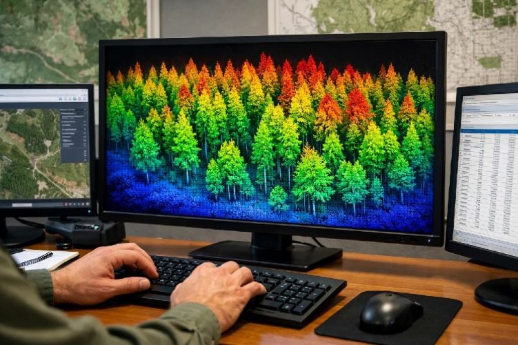
Modern forest inventory satellite technology offers capabilities that would have seemed impossible a decade ago. High-resolution optical satellites capture imagery at resolutions sufficient to identify individual tree crowns across entire management units. Synthetic Aperture Radar penetrates cloud cover and operates regardless of lighting conditions, providing consistent data acquisition even in persistently cloudy regions. And airborne LiDAR generates three-dimensional point clouds that reveal forest structure with centimeter-level precision, measuring canopy height, stem density, and understory conditions simultaneously.
The real power emerges when these data sources work together. Optical imagery provides spectral information about forest health and species composition through indices like NDVI. SAR data contributes information about biomass and structural complexity that optical sensors cannot detect. LiDAR delivers the precise height and density measurements that drive accurate volume calculations. SkyIntelGroup integrates these complementary data streams into unified analytical products that capture the full complexity of forest conditions. Rather than relying on any single technology with its inherent limitations, our multi-sensor approach leverages the strengths of each platform while compensating for individual weaknesses.
From Raw Imagery to Actionable Harvest Maps
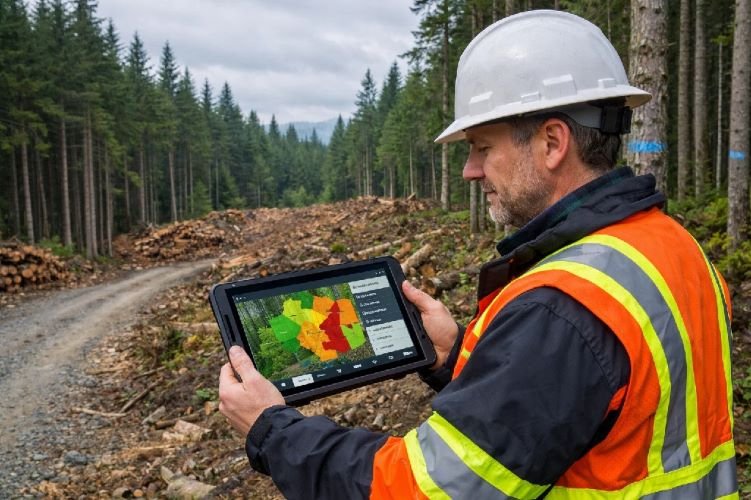
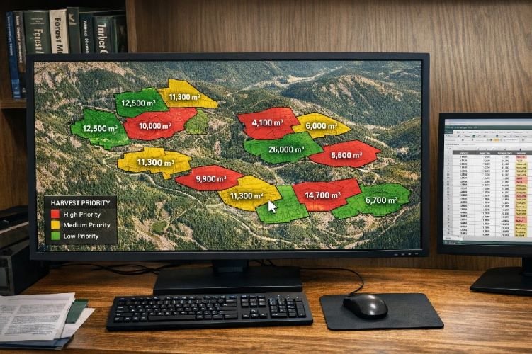
Raw satellite imagery and LiDAR point clouds hold tremendous potential, but potential alone does not improve operations. The transformation from raw data to actionable intelligence requires specialized expertise in remote sensing analysis, forestry science, and operational workflow integration. This is where many technology providers fall short. They deliver data products that technically meet specifications but require significant additional processing before they can inform actual harvest decisions.
SkyIntelGroup approaches this challenge differently. Our analysts work directly with clients to understand their specific operational requirements, planning horizons, and decision frameworks. We then configure our analytical workflows to produce deliverables that answer the questions timber managers actually need answered. Which blocks should be prioritized for harvest this season based on current volume and accessibility? Where do terrain conditions require specialized equipment or modified extraction routes? What volume mix can be expected from each harvest unit? Our outputs integrate directly into the software systems that clients already use, eliminating the friction that often prevents organizations from realizing the full value of geospatial technology investments.
| Parameter | Traditional Field Surveys | Satellite + LiDAR Integration |
|---|---|---|
| Area Coverage | ~1% sampled, 99% estimated | 100% wall-to-wall coverage |
| Volume Estimation Accuracy | R² typically 0.65–0.75 | R² consistently above 0.90 |
| Cost per Hectare | $15–$40 depending on terrain | $3–$12 at scale |
| Time to Complete Inventory | Weeks to months | Days to weeks |
| Update Frequency | Every 5–10 years typical | Annual or seasonal updates feasible |
| Terrain Data Quality | Limited to accessible areas | Complete terrain modeling including slope, aspect, soil trafficability |
| Weather Dependency | High — field work limited by conditions | Low — SAR operates through clouds |
Precision Forestry Applications for Timber Volume Estimation
LiDAR-Derived Volume Models with R² Above 0.9
The accuracy improvements that LiDAR forestry enables are not marginal refinements. They represent a fundamental shift in the reliability of timber volume estimation. Multiple peer-reviewed studies published in 2025 demonstrate that LiDAR-derived volume models consistently achieve R² values above 0.90 when validated against destructive sampling. Research conducted on tropical rainforest plots in China achieved R² values between 0.90 and 0.94 for timber volume estimation using fused handheld and UAV LiDAR data. Studies in British Columbia report that integrating LiDAR into the Enhanced Forest Inventory program has improved accuracy by more than 30% compared to traditional methods.
These accuracy gains stem from LiDAR’s ability to directly measure the three-dimensional structure of forest canopies. Traditional optical remote sensing can infer canopy characteristics from spectral reflectance, but this indirect approach introduces uncertainty. LiDAR pulses penetrate the canopy and return precise elevation measurements at multiple heights, revealing not just the top of the canopy but the vertical distribution of biomass throughout the stand. This structural information correlates strongly with merchantable volume because it captures the actual physical dimensions of standing timber rather than proxy indicators.
Real-Time Canopy Health Monitoring with NDVI
Volume estimation tells only part of the story that effective harvest planning requires. Timber quality and harvest timing decisions depend equally on understanding current forest health conditions. The Normalized Difference Vegetation Index and related spectral indices provide this insight by quantifying the photosynthetic activity and stress status of forest vegetation. Healthy, vigorous trees produce distinctive spectral signatures that differ measurably from stressed or declining trees.
Satellite-based health monitoring enables timber managers to detect problems before they become visible during ground inspections. Drought stress, early-stage insect damage, and disease infection all produce spectral changes that precede visible symptoms. By identifying stressed stands early, managers can adjust harvest priorities to capture value before it deteriorates. They can also avoid the costly surprise of discovering during harvest that timber quality has declined below expectations. Regular NDVI monitoring transforms forest health from an unknown variable into a managed parameter that informs operational decisions.
How SkyIntelGroup Delivers Harvest-Ready Intelligence
Consultative Approach — From Data to Decision
SkyIntelGroup operates fundamentally differently from satellite imagery vendors who simply deliver data products and leave interpretation to the client. Our consultative model begins with understanding each client’s specific operational context, decision requirements, and technical infrastructure. We recognize that a Timberland Investment Manager analyzing portfolio performance has different needs than an Operations Director scheduling harvest crews for the coming quarter. Both need accurate forest data, but they need it packaged and delivered in different ways to support their distinct decision processes.
This consultative approach shapes every aspect of our service delivery. During project scoping, our analysts work with clients to define the specific questions that need answers and the format those answers should take. Throughout the analytical process, we maintain communication to ensure that emerging insights get shared promptly rather than waiting for final deliverables. And after delivery, we provide support to help clients integrate our products into their operational workflows. This level of engagement requires more effort than simply processing imagery to standard specifications, but it generates dramatically more value for clients who need actionable intelligence rather than raw data.
GIS-Ready Outputs That Integrate with Remsoft, ArcGIS, and QGIS
Technical compatibility often determines whether geospatial investments deliver their promised value. Many timber operations have made significant investments in planning software like Remsoft’s Woodstock optimization platform or enterprise GIS systems built on ArcGIS. New data sources that require manual translation or custom integration create friction that reduces adoption and limits utility. SkyIntelGroup eliminates this friction by delivering outputs in formats that integrate directly with clients’ existing technical infrastructure.
Our standard deliverables include GeoTIFF rasters for continuous variables like canopy height models and volume density surfaces. Vector outputs in Shapefile and GeoJSON formats provide stand boundaries, harvest unit delineations, and point features like access points and stream crossings. Tabular data exports match the schema requirements of common forest management databases. And for clients using Remsoft, we can structure outputs to align with Woodstock’s input requirements for harvest scheduling optimization. This attention to technical integration ensures that our analytical products flow seamlessly into operational workflows rather than creating additional data management burdens.
SkyIntelGroup Service Workflow
Ready to Transform Your Harvest Planning?
Discover how satellite intelligence can improve accuracy and reduce costs across your timber operations.
Schedule a ConsultationSustainable Harvest Planning and Certification Compliance
Meeting FSC and PEFC Documentation Requirements
Forest certification under FSC and PEFC standards requires operators to demonstrate sustainable harvest planning through comprehensive documentation of forest conditions, harvest levels, and environmental protections. These certification bodies mandate that harvesting remains within the boundaries of long-term sustainable yield capacity, a requirement that depends fundamentally on accurate inventory data. Certification auditors scrutinize the evidentiary basis for harvest level calculations, and weak inventory data can trigger findings that delay or jeopardize certification status.
Satellite-based forest monitoring provides the documentation foundation that certification compliance requires. Complete spatial coverage eliminates the uncertainty inherent in sample-based extrapolation. Time-series imagery creates an auditable record of forest conditions before, during, and after harvest operations. And the objectivity of remote sensing data provides third-party verifiable evidence that supports audit responses. Nearly 300 million hectares of forest globally hold PEFC certification, with growing numbers of these operations incorporating satellite monitoring to strengthen their compliance documentation and streamline audit preparation.
EUDR Compliance Through Satellite Traceability
The European Union Deforestation Regulation introduces new requirements for companies placing timber products in EU markets to demonstrate that their supply chains are deforestation-free. This regulation requires geolocation data for the plots of land where commodities were produced, along with verification that no deforestation occurred after December 31, 2020. These requirements create significant documentation burdens for timber exporters and processors who lack systematic geospatial monitoring capabilities.
SkyIntelGroup helps clients build EUDR-compliant documentation systems by providing historical deforestation analysis, ongoing monitoring, and geolocation verification for harvest areas. Our satellite time-series analysis can confirm land use history back to the regulation’s cutoff date, providing the evidentiary basis that EUDR compliance requires. As PEFC and other certification bodies develop technology partnerships to support EUDR implementation, satellite monitoring is becoming an integral component of responsible timber supply chain management rather than an optional enhancement.
ROI of Satellite-Based Forest Operations Planning
50-70% Cost Reduction vs Manual Inventory Methods
The economic case for satellite-based precision forestry rests on documented cost reductions that compound across multiple operational dimensions. Research published by European Space Imaging and Arboair in 2025 demonstrated 50-70% cost reduction for forest inventory compared to manual tree database creation methods. These savings stem from eliminating the field crew labor, transportation, and time requirements that dominate traditional inventory costs. A management unit that previously required weeks of field work to inventory can now be assessed in days using satellite and LiDAR data processing.
The precision forestry market reflects this economic opportunity. Industry analysis projects the global market will grow from $3.54 billion in 2025 to $4.70 billion by 2030, driven by the demonstrated cost efficiencies and accuracy improvements that technology-enabled forest management delivers. Software solutions enabling real-time monitoring, predictive planning, and performance optimization are experiencing the fastest growth within this market as organizations recognize that data-driven forestry management generates measurable returns on technology investments.
30%+ Improvement in Timber Yield Prediction Accuracy
Cost reduction tells only half the ROI story. The accuracy improvements that satellite and LiDAR integration enables translate directly into better operational decisions and improved financial outcomes. British Columbia’s Ministry of Forests reports that integrating LiDAR into their Enhanced Forest Inventory program has improved accuracy by more than 30% compared to traditional methods. This accuracy improvement flows through to allowable annual cut calculations, carbon accounting, and harvest scheduling optimization.
Improved timber yield prediction enables better decisions across the operational planning horizon. Strategic planning benefits from more reliable projections of sustainable harvest levels over multi-decade timeframes. Tactical planning improves when volume estimates for specific harvest units match actual outcomes more closely. And operational scheduling becomes more efficient when the volume mix from each block can be predicted with confidence, enabling better coordination with mill demand and transportation logistics. The cumulative financial impact of these improvements typically exceeds the direct cost savings from reduced field inventory requirements.
Case Studies — Precision Forestry in Action
Pan Pac New Zealand — Automated Harvest Reporting
Pan Pac Forest Products in New Zealand provides a compelling example of satellite technology transforming forest operations planning. The company automated the collection and reporting of harvested areas using high-frequency PlanetScope imagery at 3.7-meter resolution. This implementation resulted in significant time and cost savings for their operations team while simultaneously streamlining regulatory reporting and improving data accuracy. Rather than relying on manual post-harvest surveys to document completed operations, Pan Pac now receives automated delineation of harvest boundaries that feeds directly into their reporting systems.
The operational benefits extend beyond simple efficiency gains. Consistent, objective measurement of harvested areas eliminates the variability that manual survey methods introduce. Management has better visibility into actual operational progress compared to planned schedules. And the historical archive of imagery provides documentation that supports both internal analysis and external reporting requirements. Pan Pac’s experience demonstrates that satellite monitoring delivers value not just for planning future operations but for documenting and analyzing completed activities.
BC Ministry of Forests — Wall-to-Wall LiDAR Coverage
The British Columbia Ministry of Forests has implemented one of the most comprehensive LiDAR forestry programs in North America through their Enhanced Forest Inventory initiative. Rather than sampling forest conditions through traditional plot networks, the program produces wall-to-wall coverage across entire timber supply areas. This approach captures the full spatial variability of forest conditions that sample-based methods miss, providing forest managers with near-complete data on volume, height, and basal area across their entire management unit.
The program’s results validate the substantial investment in LiDAR data acquisition and processing. Ministry reporting indicates that integrating LiDAR has improved inventory accuracy by more than 30%, reducing uncertainty in allowable annual cut calculations and carbon accounting. This accuracy improvement has direct implications for sustainable forest management, ensuring that harvest levels align with actual growth capacity rather than statistical estimates. The BC experience demonstrates that wall-to-wall LiDAR coverage, while requiring significant upfront investment, generates returns through improved decision quality across multiple planning horizons.
Frequently Asked Questions
How accurate is satellite-based timber volume estimation compared to traditional field surveys?
Satellite and LiDAR-based timber volume estimation consistently achieves higher accuracy than traditional field survey methods. Multiple peer-reviewed studies published in 2025 demonstrate that LiDAR-derived volume models achieve R² values above 0.90 when validated against ground-truth measurements. This compares favorably to traditional plot-based methods that typically achieve R² values in the 0.65-0.75 range due to the extrapolation required to estimate conditions across unsampled areas. The accuracy advantage stems from LiDAR’s ability to directly measure three-dimensional forest structure across 100% of the management area rather than sampling a small fraction and extrapolating to the whole.
What satellite and LiDAR data sources does SkyIntelGroup use for harvest planning?
SkyIntelGroup integrates multiple data sources selected based on each project’s specific requirements. For optical imagery, we utilize high-resolution commercial satellites including Maxar’s WorldView constellation, Planet’s PlanetScope and SkySat systems, and Airbus Pléiades imagery. Synthetic Aperture Radar data from Sentinel-1 and commercial providers like ICEYE enables all-weather monitoring. LiDAR data comes from airborne acquisition campaigns or existing datasets from government programs like USGS 3DEP. We select the optimal combination of sources based on factors including required resolution, temporal frequency, budget constraints, and regional data availability.
How long does it take to receive harvest-ready maps and reports?
Project timelines vary based on scope and complexity, but most harvest planning projects follow a predictable schedule. Initial scoping and data acquisition typically requires two to four weeks depending on whether new imagery tasking is required or existing archive data can be utilized. Processing and analysis adds another two to three weeks for standard projects covering up to 50,000 hectares. Larger projects or those requiring specialized analysis may extend these timelines. We work with clients to establish delivery schedules that align with their planning cycles and can expedite critical projects when operational requirements demand faster turnaround.
Can satellite data help with FSC and PEFC certification audits?
Yes, satellite monitoring provides substantial support for forest certification compliance. FSC and PEFC standards require documentation of forest conditions, harvest levels, and environmental protections that satellite data can verify objectively. Time-series imagery creates an auditable record of conditions before, during, and after harvest operations. Complete spatial coverage eliminates the documentation gaps that sample-based methods leave. And the emerging requirements of the EU Deforestation Regulation specifically require geolocation verification and historical land use analysis that satellite monitoring directly supports. Many certified operations are incorporating satellite monitoring to strengthen their compliance documentation and streamline audit preparation.
What file formats does SkyIntelGroup deliver for GIS integration?
SkyIntelGroup delivers outputs in industry-standard formats that integrate directly with common forest management and GIS platforms. Raster products including canopy height models, volume density surfaces, and spectral indices are delivered as GeoTIFF files with appropriate coordinate reference systems and metadata. Vector products including stand boundaries, harvest unit delineations, and infrastructure features are available in Shapefile, GeoJSON, and GeoPackage formats. Tabular data exports can be configured to match the schema requirements of forest management databases and planning software. For clients using Remsoft Woodstock, we can structure outputs to align directly with the platform’s input requirements for harvest scheduling optimization.
Transform Your Harvest Planning with Satellite Intelligence
Stop estimating from 1% sample plots. Get wall-to-wall forest inventory data that improves accuracy by 30% and reduces costs by up to 70%. Contact SkyIntelGroup to discuss how satellite and LiDAR technology can optimize your timber operations.