The Tailings Dam Failure No One Saw Coming — Except the Satellite
At 12:28 pm on January 25, 2019, the workers at Córrego do Feijão mine in Brumadinho, Brazil, were in the cafeteria for lunch. Dam-I collapsed without warning. Thirteen million cubic meters of iron ore tailings moved down the valley at 70 kilometers per hour. Two hundred and seventy people were killed. Vale — the company that owned the dam — eventually paid more than $7 billion in compensation and spent over $27 billion in total between settlements, environmental remediation, and the emergency program to eliminate its upstream-constructed dams across Brazil.
Years later, researchers processed archival Sentinel-1 satellite radar images from the ten months before the collapse. They found deformation in the dam wall that was not consistent with normal consolidation — and concluded that the timing of the failure would have been foreseeable based on that precursory movement. The dam had geotechnical instrumentation installed. It had been inspected. It had been certified stable. And it was already moving in ways that conventional monitoring did not detect — but that satellite data, analyzed retroactively, revealed clearly.
This article is not about Brumadinho specifically. It is about the tailings dams that are sending those same signals today — and whether anyone is reading them. SkyIntelGroup works with mining operators to make sure the answer is yes.
A Disaster That Keeps Repeating Itself
Brumadinho did not occur in isolation. It followed Mariana in 2015 — 19 dead, 668 kilometers of river contaminated all the way to the Atlantic Ocean, considered at the time the worst environmental disaster in Brazilian history. It preceded Jagersfontein in South Africa in 2022. And the sequence has continued since.
In February 2025, a tailings storage facility operated by Sino-Metals Leach Zambia catastrophically failed, releasing approximately 50 million liters of acidic and highly toxic waste into the Kafue River ecosystem. The Kafue supplies water and irrigation to approximately 60% of Zambia’s population. A single dam failure compromised the water security of a country.
In March 2025, two tailings facilities at the Indonesia Morowali Industrial Park collapsed within days of each other. The first, on March 16, sent a wave of liquefied waste into the Bahodopi River and the village of Labota, threatening 341 families. The second, five days later, killed three workers. A third tailings dam collapse at a separate site in Sulawesi followed within a week. Google Earth imagery from January 2025 — two months before the March failures — showed evidence of a previous landslide at one of the same sites. The signal was there before the disaster. It was not being read.
The statistical picture confirms what the individual events suggest: tailings dam failures are not becoming rarer. Historical analysis of 342 incidents from 1915 to 2021 documents an average of 4.4 failures per year, with frequency increasing in recent decades. The dams are getting larger because lower ore grades require processing more material to extract the same amount of metal. Larger dams hold more volume. More volume means larger consequences when containment fails.
What a Tailings Dam Failure Actually Costs — Beyond the Headline Number
The $7 billion figure attached to Brumadinho is the one that appears in press releases and ESG reports. It is not the full picture.
Vale’s total expenditure — between individual and collective compensation, environmental remediation, the emergency program to decommission upstream-constructed dams across its portfolio, and ongoing payments to more than 100,000 affected people — exceeded $27 billion. That figure does not include the collapse in share price in the days following the disaster, the increased cost of capital as investors repriced the company’s risk profile, or the projects cancelled or delayed because of lost social license in key jurisdictions.
The legal exposure extended beyond the corporate entity. Five Vale employees and two engineers from TÜV Süd — the German certification firm contracted to declare Dam-I stable — were arrested in the weeks following the collapse. The engineers had issued a positive stability certification for the dam between June and September 2018. By January 2019 it had failed. In Brazil, criminal proceedings against individuals involved in mine safety certifications have now established a precedent that other jurisdictions are observing. In Australia, Canada, and the United Kingdom, the personal liability frameworks for mining safety failures are equally serious.
The environmental cost operates on a timeline that no corporate balance sheet captures accurately. The Paraopeba River will take decades to recover. Zambia’s Kafue River ecosystem — compromised by a single tailings dam collapse in February 2025 — provides water and irrigation to a majority of the country’s population. These are not problems that close at the end of a financial year. The company responsible for the failure continues paying long after operations have ceased.
Then there is the reputational dimension. The US Securities and Exchange Commission investigated Vale for making false statements about the safety conditions of its dams before the Brumadinho collapse. The social license lost in Brazilian communities, in ESG-sensitive investor portfolios, and in the regulatory relationships that make large mining operations possible is not restored by a compensation payment. Several Vale projects that were in development at the time of the disaster never proceeded.
What Happens Inside a Tailings Dam Before It Fails
Understanding why tailings dam monitoring matters requires understanding the mechanical reality of how these structures behave before they collapse — because the process is rarely instantaneous.
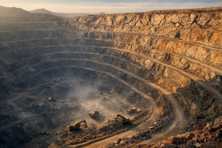
A tailings storage facility is an engineered earthen dam built incrementally as the mine produces more waste. Unlike a concrete gravity dam, its structural integrity depends on the geotechnical properties of compacted soil and tailings material — properties that change over time as water infiltrates, as the phreatic line (the internal water table) rises, as material consolidates or softens. The failure modes — overtopping, internal erosion, slope instability, static liquefaction — share a common characteristic: they develop progressively before the final collapse.
Conventional geotechnical instruments — piezometers, inclinometers, prism networks — are essential tools. They provide precise, high-frequency data at the specific points where they are installed. The limitation is structural: if dam deformation develops at a point not covered by installed instrumentation, the system does not detect it. Brumadinho had instrumentation. The developing instability was not where the instruments were looking.
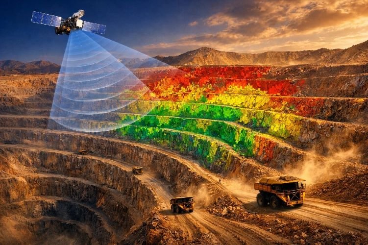
Satellite InSAR measures the entire surface of the dam in each satellite pass — the downstream face, the upstream slope, the crest, the abutments, and the terrain beyond the dam toe — at millimeter precision. It does not replace piezometers: groundwater pressure in depth requires in-situ sensors. What it does is cover the surface that point instruments cannot. In the Brumadinho retroactive analysis, researchers using 26 Sentinel-1 images from the ten months before the collapse detected anomalous deformation on the dam wall — deformation that was not consistent with normal consolidation behavior, and whose acceleration pattern was interpretable as a failure precursor. That analysis used publicly available satellite data. The monitoring was technically possible. It was not in place.
The GISTM Deadline Has Passed. Where Does That Leave You?
The Global Industry Standard on Tailings Management — GISTM — was published in 2020 in direct response to Brumadinho and Mariana. It comprises 77 auditable requirements across six operational domains, covering design, construction, operation, closure, and post-closure management of tailings storage facilities. The compliance deadline for all operational facilities was August 5, 2025.
That deadline has passed. The operator who is not in conformity today is not in a preparation phase — they are in active non-compliance, with direct exposure to independent auditors, to the institutional investors who have made GISTM conformance a condition of continued investment in mining companies, and to regulators in jurisdictions that have incorporated the standard into their own frameworks.
The monitoring dimension of GISTM is specific: the standard requires a system that provides coverage across the full extent of the facility, with defined alert thresholds, documented response protocols, and periodic review by a qualified responsible person. The Dam Safety Engineer who can demonstrate continuous, full-surface deformation monitoring with a documented baseline and alert history is in a fundamentally different position — legally, regulatorily, and with the company’s insurer — than one who cannot.
The largest operators have already moved. Glencore entered a global agreement with TRE Altamira to extend satellite monitoring to over 110 of its tailings dams worldwide. Anglo American reports GISTM conformance above 95% across its portfolio. The institutional investors whose capital funds mid-size mining operations are applying the same scrutiny. The gap between where the large operators are and where many mid-size operations remain is exactly the exposure that the next failure will exploit.
For operations managing both active tailings facilities and open pit slopes, the monitoring logic is identical — and the two programs complement each other directly. The same satellite data that tracks TSF monitoring across the dam structure can cover pit wall deformation in the same footprint, as we cover in detail in our analysis of open pit slope failure.
How SkyIntelGroup Monitors Tailings Dams
The operational question for a Dam Safety Engineer reviewing their monitoring program is straightforward: does the current system cover the entire surface of the structure, or only the points where instruments were installed at the time of the original design?
SkyIntelGroup delivers satellite-based deformation monitoring for tailings storage facilities of any construction method — upstream, downstream, or centerline — in any jurisdiction, without requiring installation of additional equipment at the site. Analysis uses SAR satellite imagery processed through interferometric methods to detect surface displacement at millimeter scale across the complete dam footprint: the downstream face, upstream slope, crest, abutments, perimeter embankments, and surrounding terrain.
The historical baseline is one of the most operationally significant aspects of the service. Sentinel-1 imagery is available from 2014 onward for virtually every mine site globally. This means that the first analysis delivered includes more than a decade of the facility’s deformation history — information that no newly installed monitoring system can provide retrospectively. For facilities that have never had InSAR monitoring, this historical record is the starting point for understanding whether the structure has been behaving consistently or has been developing a trend that the conventional instrumentation did not capture.
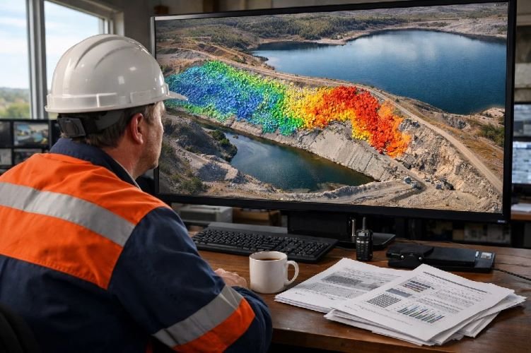
Output is structured for operational use: velocity maps across the full dam surface, time-series graphs for zones of interest, and alert thresholds set with the client’s geotechnical team that trigger notification when movement rates exceed defined parameters. The service is fully compatible with existing geotechnical instrumentation programs and with GISTM documentation requirements. SkyIntelGroup’s complete Mining services portfolio covers the full range of satellite intelligence for mining operations, from tailings dam monitoring to slope stability and environmental compliance.
Frequently Asked Questions About Tailings Dam Failure
What did satellite data show before the Brumadinho tailings dam failure?
Retroactive analysis of Sentinel-1 satellite radar imagery, published in Communications Earth & Environment in 2021, found that parts of the Dam-I wall and tailings at Brumadinho were experiencing deformation not consistent with normal consolidation in the months before the January 2019 collapse. The researchers concluded that the timing of the failure would have been foreseeable based on the observed precursory deformation pattern. A separate analysis using SBAS and PSI interferometric techniques on 26 Sentinel-1 images from the ten months prior to the collapse detected displacement on the downstream slope face of the dam. The dam had conventional geotechnical instrumentation installed and had been certified stable. The satellite data, analyzed retroactively, showed what the conventional system did not.
What does the GISTM require for tailings dam monitoring in 2026?
The Global Industry Standard on Tailings Management requires that tailings storage facilities be monitored with a system that provides coverage appropriate to detect instability before it becomes critical, with defined alert thresholds, documented response protocols, and review by a qualified responsible person. The compliance deadline for all operational facilities was August 5, 2025. The standard does not prescribe specific technologies — it requires demonstrable performance. A monitoring system that covers only the points where conventional instruments were installed, without full-surface coverage, creates a defensibility gap that auditors and regulators are increasingly examining in the context of GISTM conformance assessments.
Can satellite InSAR monitoring be used alongside existing geotechnical instruments?
Yes — and this is the standard operational model for the programs delivering the most complete coverage. Conventional instruments such as piezometers and inclinometers provide high-frequency, precise measurements at specific depth points within the dam structure. They are essential for monitoring groundwater pressure and localized subsurface movement. Satellite InSAR provides the complementary capability: wide-area surface deformation measurement across the entire dam footprint at millimeter precision, without requiring physical access or additional field installation. The two approaches address different aspects of dam behavior and are most effective when used together — the satellite data identifying where on the surface anomalous movement is developing, and the ground instruments providing the subsurface context at those specific zones.
How quickly can SkyIntelGroup set up tailings dam monitoring for an active facility?
Because satellite monitoring requires no field installation, the setup process is significantly faster than deploying conventional instrumentation. Once the facility boundaries are defined — a shapefile or coordinates of the tailings storage facility — SkyIntelGroup identifies the available satellite imagery for that area, processes the archive to build the historical baseline, and delivers the first analysis covering the full deformation history of the structure since 2014. For most mine sites globally, recent satellite imagery is readily available and the initial baseline analysis can be delivered within a short timeframe from engagement. Ongoing monitoring updates are then delivered on a schedule agreed with the client’s geotechnical team, aligned with the frequency required for GISTM compliance documentation.
Conclusions
The tailings dams that have failed over the past decade — Mariana, Brumadinho, Jagersfontein, Zambia, Indonesia — were not failures of engineering knowledge. The geotechnical community has understood how these structures fail for decades. They were failures of monitoring coverage: systems that measured the right things in the wrong places, or measured too infrequently to catch the acceleration that precedes collapse.
The satellite data that would have revealed Brumadinho’s precursory deformation was available. The technology to process it existed. The failure was not technical — it was operational. Nobody was looking at the full surface of the dam with the right instrument.
In 2026, with the GISTM deadline passed, with institutional investors demanding transparency, and with the personal legal exposure of Dam Safety Engineers now established by precedent in multiple jurisdictions, the question is not whether full-surface monitoring is worth the investment. The question is whether the current program would have seen what the satellite saw at Brumadinho — and what the answer to that question implies about the next event.