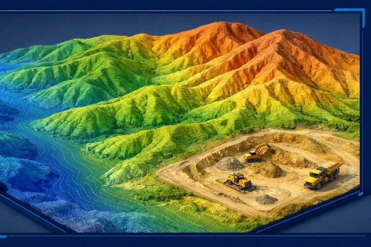
Infrastructure Monitoring: How Satellite Technology Detects Structural Problems Before They Become Disasters (2026)
A landmark study published in Nature Communications in March 2026 analyzed 744 long-span bridges across the globe and revealed a startling gap in how we protect critical infrastructure. Fewer than 20% of these structures have any form of structural health monitoring system installed. Yet the same research demonstrated that satellite-based radar technology could provide monitoring capability for over 60% of the world’s bridges — and incorporating this approach into routine assessments could reduce the number of structures classified as high-risk by one-third.
This finding arrives at a critical moment. Transportation networks worldwide are approaching a breaking point. In the United States, the average bridge is 47 years old — approaching the end of its original 50-year design life — while 6.8% of the nation’s 623,218 bridges are already rated as structurally deficient. Across Europe, more than 200,000 railway bridges require monitoring, many built over 50 years ago to codes that did not account for today’s heavier loads and more frequent traffic. Japan faces 700,000 bridges nationwide, with projections showing that 60% will exceed 50 years of age by 2033. The infrastructure crisis is not confined to any single region; it is a global challenge demanding new solutions.
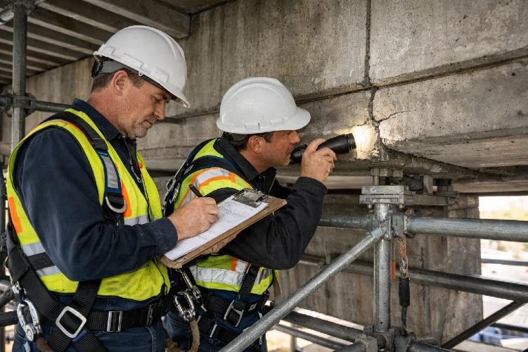
Traditional inspection methods cannot keep pace with these demands. Visual inspections occur only every three to five years, require expensive personnel access to often dangerous locations, and depend on subjective assessments that cannot detect the millimeter-scale movements that precede structural failures. Infrastructure monitoring through satellite technology offers a fundamentally different approach: continuous, wide-area surveillance that tracks displacement trends across entire transportation networks, identifies emerging problems months before they become visible, and delivers this intelligence without installing a single sensor on any structure.
The Global Infrastructure Challenge: Why Traditional Monitoring Falls Short
Aging Infrastructure Across Continents
The scale of aging infrastructure extends far beyond any single country. In the United States, the American Society of Civil Engineers estimates that $538 billion in investment is needed for bridges alone between 2024 and 2033. Some 171.5 million trips cross structurally deficient bridges every day. But the challenge is equally acute elsewhere.
Europe’s railway network includes more than 228,000 kilometers of track and over 200,000 bridges, many constructed more than a century ago to standards that predate modern loading requirements. By 2030, passenger traffic is forecast to increase by 34% and freight by 40% compared to 2005 levels, meaning these aging structures will face ever-greater demands while maintenance windows shrink. Individual structures in the United Kingdom’s London Underground system are 75 to 100 years old. The Hammersmith Bridge in West London has been closed to motorized vehicles for more than three years, with stabilization and strengthening costs exceeding £100 million.
Japan manages the largest bridge maintenance burden in the developed world with over 700,000 structures nationwide. Government projections indicate that 60% of these bridges will exceed 50 years of age by 2033, requiring extensive monitoring and maintenance programs that current methods cannot deliver cost-effectively. Similar pressures face rapidly urbanizing regions across Asia, where infrastructure must serve populations far larger than planners originally anticipated.
The Limitations of Visual Inspections
Traditional bridge monitoring relies primarily on visual inspections conducted every three to five years by engineers who physically access structures to document their condition. While valuable, this approach has fundamental limitations that become increasingly problematic as infrastructure ages and demands grow.
Visual inspections are inherently subjective. Different inspectors may assess the same crack or corrosion pattern differently, and subtle changes between inspection cycles can be missed entirely. More critically, human eyes cannot detect the millimeter-scale movements that often precede structural failures. A bridge settling at 2mm per year — well within the detection capability of satellite radar — would be invisible to visual inspection until the accumulated displacement produced visible cracking or misalignment.
The researchers behind the Nature Communications study emphasized this gap directly: «While using MT-InSAR to monitor bridges is well-established in academic circles, it has yet to be routinely adopted by the authorities and engineers responsible for them. Our work provides the global-scale evidence showing this is a viable and effective tool that can be deployed now.»
How Satellite InSAR Technology Transforms Infrastructure Monitoring
The Science Behind Millimeter-Precision Detection
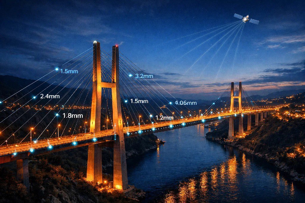
InSAR technology — Interferometric Synthetic Aperture Radar — represents a fundamentally different approach to monitoring structures. Rather than relying on periodic human observation, InSAR uses radar signals transmitted from orbiting satellites to measure how surfaces have moved between successive passes.
The technique works by comparing the phase of radar waves reflected from the same location at different times. When a surface moves — even by just a few millimeters — the phase of the returning signal shifts measurably. By analyzing these phase differences across thousands or millions of measurement points, InSAR processing algorithms can create detailed maps showing exactly how structures and the ground around them are displacing over time.
Modern InSAR processing achieves 1-2mm precision in detecting vertical and horizontal movements. This sensitivity enables identification of settlement, tilting, subsidence, and other displacement patterns months or even years before they produce visible damage. Because radar signals penetrate clouds and operate day or night, the technology provides all-weather, continuous monitoring capability that does not depend on lighting conditions or clear skies.
Critically, satellite-based infrastructure monitoring requires no equipment installation on the structures being monitored. There are no sensors to maintain, no traffic disruptions during setup, and no ongoing hardware costs. The entire monitoring infrastructure exists in orbit, delivering measurements remotely to wherever analysis is conducted.
From Reactive Repairs to Predictive Maintenance
The shift from reactive to predictive maintenance represents one of the most significant operational transformations available to infrastructure managers. Rather than waiting for problems to become visible — or worse, for failures to occur — predictive maintenance infrastructure strategies use continuous data to identify emerging issues while intervention remains straightforward and inexpensive.
Research consistently demonstrates the economic value of this approach. McKinsey analysis shows that organizations implementing predictive maintenance achieve ROI ratios of 10:1 to 30:1, typically within 12 to 18 months of deployment. Downtime reductions of 30-50% are common, while asset lifespans extend by 20-40% through optimized maintenance timing. The U.S. Department of Energy documents even more dramatic results: 70-75% decreases in breakdowns for organizations that successfully transition from reactive to predictive approaches.
For infrastructure specifically, AI-powered predictive monitoring has been shown to reduce failures by 73%. These gains come not from repairing more aggressively, but from repairing more intelligently — directing limited maintenance resources to where they will have the greatest impact based on objective displacement data rather than inspection schedules or educated guesses.
Real-World Applications: Bridges, Tunnels, and Transportation Corridors
Bridge Monitoring — Detecting Structural Shifts Globally
The application of satellite remote infrastructure monitoring to bridges has produced documented results across multiple continents. In Flanders, Belgium, a monitoring program using TerraSAR-X data covered 3,126 square kilometers and tracked displacement across the region’s entire bridge inventory simultaneously — something that would require years of sequential inspections using traditional methods.
Perhaps the most compelling demonstration of early warning capability occurred at Tadcaster Bridge in the United Kingdom. InSAR analysis detected deformation patterns weeks before the bridge suffered a partial collapse due to scour during flooding. This case highlighted exactly the type of early warning that visual inspections miss: gradual displacement that builds over time until a threshold is crossed and failure occurs suddenly.
In Italy, researchers validated a clustering algorithm for automated classification of bridge displacement patterns using COSMO-SkyMed satellite data. The study examined the Po River Bridge and the Colle Isarco Viaduct, demonstrating that the technique could identify anomalies and distinct behaviors across various portions of structures with minimal user input — opening the door to large-scale automated monitoring that scales across entire national bridge inventories.
Tunnel Deformation Monitoring — Surface and Subsurface Intelligence
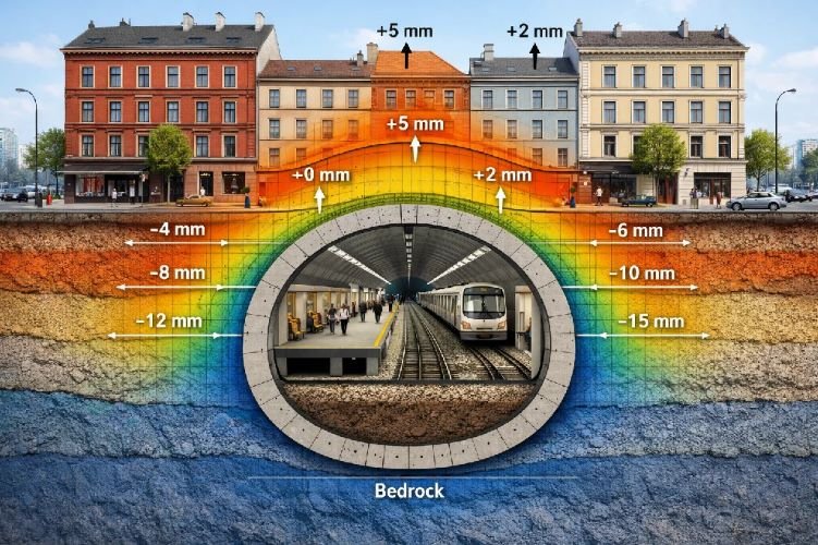
Tunnel deformation monitoring presents unique challenges because the assets themselves are underground. However, tunnel construction and operation induce measurable surface effects that InSAR captures with high precision.
When tunnels are excavated through soft soils, they cause settlement at the surface that can affect buildings and infrastructure above. The Amsterdam North/South Metro Line provided a key validation case, with InSAR measurements compared against traditional leveling surveys throughout the tunnel construction process. The satellite data proved valuable not only during construction but also before and after — revealing settlement patterns outside the area covered by conventional survey benchmarks and providing information about long-term ground behavior that persists after monitoring crews have moved on.
The Naples Metro Line 6 project demonstrated how InSAR can calculate volume loss during twin tunnel excavation — a critical parameter for predicting ground movements. By fitting Gaussian curves to monitored settlement data, engineers could predict the surface impact of the second excavation based on observations from the first, enabling proactive protection of nearby structures.
Madrid’s Metro Line 7B offers a cautionary tale of what happens when subsidence goes undetected or unaddressed. More than 600 homes in San Fernando de Henares have been affected by ground movement associated with the subway line, with some buildings evacuated and others demolished due to serious collapse risk. InSAR analysis documented the deformation with millimeter precision, identifying exactly when acceleration began and which structures faced the greatest differential settlement — information that could enable targeted intervention before damage becomes irreversible.
Railway and Highway Corridor Surveillance
Linear infrastructure presents particular challenges for traditional monitoring because assets extend across hundreds or thousands of kilometers, often through remote or difficult terrain. Satellite-based ground deformation monitoring transforms this challenge into an advantage: the same satellite pass that images a city center also captures data along the entire length of connecting highways and railways.
Europe’s 228,000 kilometers of railway track pass through diverse geological conditions, from stable bedrock to subsidence-prone soft soils and slopes vulnerable to landslides. Climate change is accelerating deterioration through more frequent extreme weather events. Historical documentation shows rail infrastructure failing due to weather effects dating back to the earliest modern railways — and climate projections indicate these pressures will intensify.
InSAR enables continuous detection of settlement patterns along transportation corridors, early warning of slope instability that could trigger landslides onto tracks or roads, and rapid post-earthquake damage assessment across entire networks. For highway corridors passing through mining-affected areas, satellite monitoring tracks vertical displacements that enable preemptive repairs and alternate routing before surface conditions become dangerous.
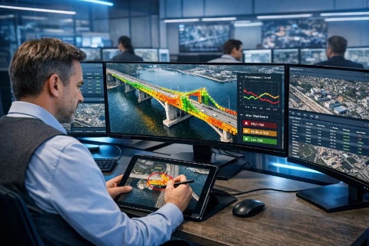
Protect Critical Infrastructure with Millimeter-Precision Monitoring
Whether you manage bridges in Europe, tunnels in Asia, or highways in the Americas, satellite-based deformation monitoring delivers the early warning capability your assets need.
Satellite Monitoring vs Traditional Methods: A Direct Comparison
Coverage, Frequency, and Cost Advantages
The economics of satellite infrastructure inspection differ fundamentally from traditional approaches. Visual inspections require personnel on-site, often with specialized access equipment, traffic control, and safety measures. Ground-based sensor networks demand installation costs ranging from $50,000 to $500,000 per bridge, plus ongoing maintenance and data management overhead.
Satellite InSAR covers hundreds of kilometers simultaneously in a single processing operation. There is no equipment to install, no traffic to disrupt, no scaffolding to erect. The satellites are already in orbit, acquiring data continuously; the only variable cost is processing and analysis. Studies indicate potential cost reductions of 40-50% compared to ground-based sensor networks for equivalent monitoring capability.
This economic advantage grows with scale. Monitoring a single bridge via satellite may offer modest savings over traditional methods, but monitoring an entire regional bridge inventory — hundreds or thousands of structures — becomes dramatically more cost-effective through satellite than through any ground-based approach. Industry data shows that 85% of major infrastructure projects now consider InSAR for stability assessments, reflecting growing recognition of these economics.
Complementary Approaches — Not Replacement
Satellite infrastructure stability monitoring does not replace traditional inspections; it makes them more effective by directing attention where it matters most. InSAR excels at detecting displacement trends across wide areas, but it cannot see inside structures, examine joint conditions, or assess material deterioration directly. Visual inspection remains essential for these tasks.
The most effective approach combines satellite monitoring with targeted ground-based inspection in what practitioners call a «tip and cue» model. Satellites continuously scan entire networks, identifying areas showing displacement acceleration or anomalous behavior. These flagged locations then receive priority attention from inspection crews, who can focus their limited time and resources on structures that objective data indicates may be developing problems.
This integration extends to other sensor technologies as well. GNSS provides real-time positioning for critical structures where daily or hourly measurements are needed. LiDAR delivers detailed 3D geometry for specific assets. IoT sensors can monitor strain, temperature, and vibration at key points. Each technology contributes complementary information, with satellite InSAR providing the wide-area context that makes localized measurements meaningful.
The Business Case: Quantifiable ROI of Satellite Infrastructure Monitoring
Maintenance Cost Reduction and Asset Lifespan Extension
The financial case for asset integrity management through satellite monitoring rests on documented outcomes across industries. Organizations that successfully implement predictive maintenance strategies consistently report 18-31% reduction in overall maintenance expenditures — not through cutting corners, but through optimizing timing and avoiding emergency repairs that cost 3-5 times more than planned interventions.
Asset lifespans extend by 20-40% when maintenance shifts from reactive to condition-based approaches. Infrastructure that might have required replacement in 30 years can continue serving safely for 40 or more when problems are detected and addressed early. For bridges, tunnels, and other structures with replacement costs measured in hundreds of millions of dollars, this extension represents enormous value preservation.
The U.S. Department of Energy documents that organizations achieving predictive maintenance maturity see 70-75% decreases in breakdowns. While infrastructure assets differ from manufacturing equipment, the underlying principle holds: monitoring that detects degradation early enables intervention that prevents catastrophic outcomes.
Safety, Liability, and Regulatory Compliance
Beyond direct cost savings, satellite monitoring delivers value through risk reduction and documentation. Infrastructure failures can result in loss of life, massive liability exposure, and regulatory consequences. The Morandi Bridge collapse in Genoa killed 43 people and left 600 homeless; legal and financial repercussions continued for years. Any monitoring capability that reduces such risks commands serious consideration.
Objective displacement data provides documentation that subjective inspection reports cannot match. When structures show stable behavior over time, that record supports decisions to maintain current operations. When displacement accelerates, the same record provides early warning and justification for intervention. Should disputes arise about when problems began or whether warning signs were present, historical InSAR analysis can reconstruct conditions going back years or even decades.
How We Deliver Infrastructure Monitoring Solutions
Our DInSAR Expertise for Civil Engineering
Millimeter-precision Differential InSAR processing represents a core competency that distinguishes our approach from generic satellite imagery providers. Processing radar data to extract meaningful displacement measurements requires specialized algorithms, experienced analysts, and careful attention to error sources that can corrupt results if not properly handled.
Our team delivers multi-temporal analysis that reveals not just current displacement, but the trajectory of movement over months or years. This time-series perspective distinguishes normal seasonal behavior — thermal expansion, cyclical loading — from progressive deterioration that requires attention. When a structure shows 3mm of settlement, context matters enormously: is this the end of a one-time consolidation process, or the latest increment in an accelerating trend?
Results integrate directly with client systems rather than requiring adoption of proprietary platforms. Whether your organization uses GIS software, bridge management systems, or enterprise asset management platforms, we deliver data in formats that flow into existing workflows. Georeferenced shapefiles, KML files for visualization, tabular exports for database integration — the format adapts to your needs rather than forcing you to adapt to ours.
From Raw Data to Actionable Intelligence
The difference between data and intelligence lies in interpretation. Satellite radar produces terabytes of raw phase measurements; converting those measurements into decisions about where to focus maintenance resources requires expertise that bridges remote sensing technology and civil engineering practice.
Our analysis identifies not just where displacement is occurring, but what that displacement likely means. Settlement concentrated around a bridge pier suggests different concerns than settlement distributed along an approach embankment. Seasonal patterns that correlate with temperature or groundwater levels differ from monotonic trends that indicate progressive failure. These distinctions shape recommendations that turn monitoring data into maintenance action.
For clients implementing continuous monitoring programs, we establish alert thresholds calibrated to each structure’s history and criticality. When displacement exceeds defined parameters or acceleration is detected, alerts trigger review processes that connect satellite observations to engineering response. This integration transforms monitoring from a periodic reporting exercise into an active risk management system.
Serving Transportation Authorities, Engineering Firms, and Asset Owners Globally
Our services reach clients across sectors and geographies. Government transportation departments use infrastructure monitoring to prioritize inspection resources and justify maintenance budgets with objective data. Private infrastructure operators — toll road concessionaires, tunnel operators, railway companies — protect their assets and demonstrate due diligence to regulators and insurers. Engineering consultancies incorporate satellite data into design validation, construction monitoring, and forensic analysis.
Because satellite monitoring is inherently remote, geography presents no barrier. The same analytical capabilities that serve clients in North America apply equally to projects in Europe, Asia, Africa, or anywhere structures require monitoring. Satellite coverage is global; our capacity to deliver insights follows.
For organizations managing assets that span multiple sectors, our cross-domain expertise adds value. Smart Cities applications connect urban infrastructure monitoring to broader municipal management. Mining experience with slope stability translates directly to highway cut-slope monitoring and dam surveillance. The underlying technology and analytical methods transfer across domains, while sector-specific knowledge ensures recommendations fit operational context.
Start Monitoring Your Infrastructure from Space
From bridges and tunnels to railways and highways, our team delivers the satellite intelligence you need to prevent failures and optimize maintenance budgets — anywhere in the world.
Frequently Asked Questions
What types of infrastructure can be monitored with satellite InSAR?
Satellite InSAR is effective for monitoring bridges, tunnels, highways, railways, dams, retaining walls, metro stations, and buildings. Any structure with stable radar reflectors — concrete, steel, asphalt surfaces — can be tracked for millimeter-scale displacement over time. The technique works particularly well for structures that experience slow-moving phenomena like settlement, subsidence, or gradual tilting that precede structural failures. Linear infrastructure such as pipelines, power transmission corridors, and canal systems also benefit from the wide-area coverage that satellite monitoring provides.
How accurate is satellite-based infrastructure monitoring compared to ground sensors?
Modern InSAR processing achieves 1-2mm precision in measuring ground and structural displacement. This level of accuracy enables detection of settlement, tilting, or deformation months before visible damage occurs. While ground-based sensors can achieve sub-millimeter precision at specific instrumented points, InSAR provides comparable accuracy across thousands of measurement points simultaneously — covering entire transportation corridors or urban areas in a single analysis. The density of measurement points often exceeds 100,000 per square kilometer in urban environments, creating comprehensive coverage that point-based sensors cannot match economically.
Can satellite monitoring detect problems in underground tunnels?
InSAR detects surface deformation caused by tunnel construction and operation rather than imaging the tunnel interior directly. When tunnels are excavated in soft soils, they induce measurable settlement at the surface that InSAR captures with high precision. Case studies from Amsterdam, Naples, Madrid, Shenzhen, and cities across Asia demonstrate that surface deformation patterns reliably indicate subsurface conditions and construction impacts on nearby buildings. This capability proves particularly valuable for monitoring settlement above operating metro lines and for documenting construction impacts on surrounding properties.
How far back can historical infrastructure data be analyzed?
Sentinel-1 data is available from 2014, while earlier satellites like ERS and Envisat provide archives dating back to 1992. This historical depth allows establishment of long-term deformation baselines, reconstruction of pre-failure conditions for forensic analysis, and assessment of how infrastructure has responded to decades of use, traffic loading, and environmental stress. For projects where understanding historical behavior matters — whether for baseline establishment, legal documentation, or trend analysis — this archival capability provides context that no recently installed monitoring system can offer.
What is the typical cost of satellite infrastructure monitoring compared to traditional methods?
Satellite monitoring typically costs 30-50% less than deploying ground-based sensor networks, with no installation or maintenance burden. There is no traffic disruption during monitoring, no personnel required on-site, and no equipment to maintain or calibrate. Pricing depends on area coverage, reporting frequency, and analysis depth required, but the cost-effectiveness improves dramatically as the monitored area increases — making InSAR particularly advantageous for linear infrastructure like railways and highways where hundreds of kilometers can be processed in a single analysis. For organizations managing large asset portfolios, the economics become compelling: monitoring an entire regional bridge inventory via satellite costs a fraction of what equivalent ground-based sensor coverage would require.
How quickly can satellite monitoring detect emerging structural problems?
With modern satellite constellations providing imagery every 6-12 days, displacement trends can be identified within weeks to months depending on the rate of movement. Slow-moving phenomena like gradual settlement or subsidence become visible through time-series analysis long before they reach critical thresholds. The Tadcaster Bridge case in the UK demonstrated that InSAR detected deformation weeks before partial collapse — providing exactly the type of early warning that traditional inspections miss. For faster-moving situations, commercial constellations like COSMO-SkyMed can provide revisit times as short as 4 days, enabling more rapid detection when circumstances warrant enhanced monitoring frequency.
Is satellite InSAR monitoring suitable for regions with frequent cloud cover?
Yes, this is one of the primary advantages of SAR-based monitoring. Unlike optical satellites that require clear skies, Synthetic Aperture Radar operates through clouds, rain, fog, smoke, and darkness. The radar signal penetrates atmospheric conditions that would blind conventional cameras. This all-weather capability makes InSAR particularly valuable for infrastructure in tropical regions with frequent precipitation, northern latitudes with extended cloud cover, and areas prone to wildfire smoke or industrial haze where optical monitoring would be unreliable or impossible for extended periods.
How does satellite monitoring integrate with existing asset management systems?
InSAR deliverables can be formatted to integrate with Bridge Management Systems (BMS), GIS platforms, and enterprise asset management software. Output options include georeferenced shapefiles compatible with ArcGIS and QGIS, KML files for Google Earth visualization, tabular data exports for database integration, and custom report formats matching organizational requirements. Our team works with clients to ensure that displacement data flows directly into existing maintenance planning workflows rather than creating parallel information silos. For organizations using digital twin platforms or Building Information Modeling (BIM) systems, displacement data can feed directly into these environments to support integrated asset visualization and decision-making.
Conclusion
The infrastructure crisis facing transportation networks worldwide is not a future concern — it is a present reality demanding immediate attention. Bridges in North America, Europe, Asia, and beyond are approaching or exceeding their design lifespans while inspection methods remain fundamentally unchanged from decades past. The Nature Communications study analyzing 744 bridges globally demonstrated both the scale of the gap and the path forward: satellite-based monitoring can extend meaningful surveillance to over 60% of structures currently lacking any form of continuous observation.
The economics strongly favor adoption. ROI ratios of 10:1 to 30:1, maintenance cost reductions of 18-31%, asset lifespan extensions of 20-40%, and breakdown reductions of 70-75% are not theoretical projections but documented outcomes from organizations that have successfully transitioned to predictive approaches. For infrastructure managers facing constrained budgets and expanding maintenance backlogs, satellite monitoring offers a path to do more with less — not through deferred maintenance, but through smarter allocation of resources to where they matter most.
For those responsible for bridges, tunnels, railways, or highways anywhere in the world, the question is no longer whether satellite infrastructure monitoring technology works. Validated case studies from Belgium to Italy, the UK to China, demonstrate proven capability. The question is how quickly your organization will incorporate these tools into asset management practice. Every month of delay represents continued reliance on inspection methods that cannot detect the millimeter-scale movements preceding structural problems — and continued exposure to risks that modern technology can identify and help prevent. Explore our Construction services to learn how we can help protect your critical infrastructure assets, or visit our homepage to discover the full range of satellite intelligence solutions we deliver.