Satellite Detection of Striga Weed in Maize Fields: How Remote Sensing Achieved 92% Accuracy in Kenya
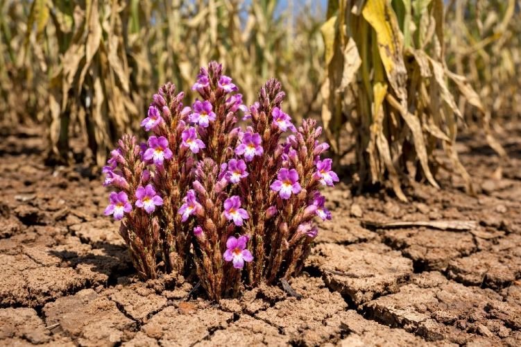
Smallholder maize farmers across Sub-Saharan Africa face an invisible enemy that destroys their crops from underground. Striga hermonthica, the parasitic witchweed, attaches to maize roots and extracts water and nutrients before any visible symptoms appear above the soil. By the time farmers spot the distinctive purple flowers emerging near their stunted crops, yield losses of 30% to 100% have already occurred. This case study examines how researchers from the International Centre of Insect Physiology and Ecology (ICIPE) deployed satellite detection of Striga in maize fields across western Kenya, achieving classification accuracies of 88% to 92% using freely available and commercial satellite imagery.
The implications extend far beyond academic research. For agricultural development organizations, government extension services, and precision agriculture service providers, this methodology offers a scalable, cost-effective approach to protecting millions of farming families from catastrophic crop losses.
The $7 Billion Crisis Devastating African Agriculture
The economic scale of Striga infestation defies comprehension. According to the International Atomic Energy Agency (IAEA), annual crop losses across Africa exceed $7 billion, impacting over 300 million people across 50 million hectares of infested farmland. In Sub-Saharan Africa alone, approximately 75% of cultivated maize land is endemic to Striga hermonthica, making it the single most destructive biological constraint to cereal production on the continent.
The parasitic weed’s biology creates a perfect storm of agricultural devastation. Each Striga plant produces 20,000 to 50,000 seeds that remain viable in soil for 15 to 20 years. The seeds germinate only in response to chemical signals from host crop roots, at which point they attach underground and begin extracting resources. A single Striga plant inflicts approximately 5% yield loss on its host, and severe infestations routinely cause complete crop failure.
Traditional detection methods have proven inadequate. Ground-based scouting requires extensive labor, covers limited area, and typically identifies infestations only after the weed emerges aboveground, when 70% or more of the damage has already occurred. Extension officers in Kenya serve ratios of 1:1,000 farmers or worse, making individual field inspections logistically impossible. Farmers in heavily infested regions like western Kenya have been forced to abandon their land entirely, with devastating consequences for household food security and rural economies.
The Striga Crisis in Numbers
Study Location: Rongo Sub-County, Migori, Kenya
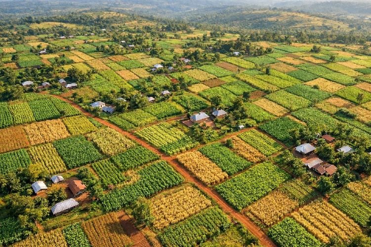
The research was conducted in Rongo sub-county within Migori County, western Kenya. This region exemplifies the challenges facing smallholder agriculture across the Lake Victoria basin. The study area, bounded by coordinates 0°39’12″S to 0°59’16″S and 34°35’40″E to 34°37’21″E at 1,470 meters elevation, receives adequate annual rainfall of 1,600 to 1,800 millimeters across two growing seasons.
Despite favorable climatic conditions, maize productivity in Rongo remains critically low at 0.8 to 1.6 tons per hectare, far below the 5+ tons achievable under optimal management. The agricultural landscape presents unique monitoring challenges: fields average just 30 square meters, farmers practice intensive intercropping of maize with beans, groundnuts, and cassava, and Striga occurs beneath the crop canopy rather than as a distinct surface feature.
According to research published by Kenyatta University, low soil fertility, inadequate fertilizer use, and persistent Striga infestation combine to trap farming families in cycles of poverty and food insecurity. The Migori County government has prioritized agricultural development, including certified seed distribution programs in Rongo, but effective Striga management requires detection capabilities that ground-based approaches cannot provide at scale.
Satellite Technology and Machine Learning Methodology
The research team, led by Bester Tawona Mudereri from ICIPE and the University of the Western Cape, deployed a comparative analysis of two satellite platforms representing different technological approaches to remote sensing for agricultural monitoring.
Sentinel-2, operated by the European Space Agency through the Copernicus program, provides freely available multispectral imagery at 10-meter spatial resolution with 13 spectral bands spanning 440 to 2,280 nanometers. The twin-satellite constellation achieves global coverage every 5 days, enabling systematic monitoring throughout growing seasons.
PlanetScope, a commercial constellation of over 175 CubeSat nanosatellites operated by Planet Labs, delivers daily global imagery at 3-meter resolution across four spectral bands in the visible and near-infrared range. While requiring commercial licensing, PlanetScope’s higher spatial resolution and daily revisit capability offer advantages for fine-scale agricultural applications.
Field surveys conducted December 12–16, 2017, established ground truth data across Rongo’s four administrative wards. Researchers documented Striga presence or absence at field centers using GPS instruments with ±3-meter accuracy, capturing geotagged photographs to verify cropping systems and growth stages. This timing coincided with peak Striga flowering and maize reproductive stages R1–R6, maximizing spectral contrast between healthy and parasitized vegetation.
The analytical framework employed Guided Regularized Random Forest (GRRF), an advanced machine learning algorithm that identifies optimal predictive variables while eliminating data redundancy. Unlike standard random forest approaches, GRRF uses importance scores to guide variable selection, producing efficient classification models with reduced computational overhead.
Seven vegetation indices were computed from both satellite datasets:
- NDVI (Normalized Difference Vegetation Index) — chlorophyll content and plant vigor
- ARVI (Atmospheric Resistance Vegetation Index) — vegetation health with atmospheric correction
- SAVI (Soil Adjusted Vegetation Index) — vegetation signal corrected for soil background
- MSAVI2 (Modified Soil Adjusted Vegetation Index) — enhanced soil influence elimination
- RVI (Ratio Vegetation Index) — simple red/NIR ratio for vegetation discrimination
- DVI (Difference Vegetation Index) — NIR minus red for biomass estimation
- IPVI (Infrared Percentage Vegetation Index) — vegetation cover sensitivity
The GRRF algorithm determined that visible spectrum bands (blue, green, red), near-infrared, and ARVI provided the optimal variable combination for Striga detection. This finding has significant practical implications: standard multispectral satellite data, rather than expensive hyperspectral sensors, can effectively support operational weed monitoring programs.
Satellite Platform Specifications
| Parameter | PlanetScope | Sentinel-2 |
|---|---|---|
| Spatial Resolution | 3 meters | 10 meters |
| Spectral Bands | 4 (VNIR) | 13 (440–2280nm) |
| Revisit Time | Daily | 5 days |
| Data Access | Commercial license | Free (Copernicus) |
Results: 92% Detection Accuracy Across Smallholder Landscapes
The classification results demonstrated that satellite detection of Striga in maize fields is not only feasible but highly accurate, even in complex, fragmented smallholder farming landscapes where field sizes average just 30 square meters.
PlanetScope achieved 92% overall accuracy with a Kappa coefficient of 0.89, successfully distinguishing six land cover classes: Striga-infested maize, healthy maize, bare soil, built-up areas, natural vegetation, and water bodies.
Sentinel-2 performed only marginally lower at 88% overall accuracy with a Kappa of 0.82—a deviation of just 4 percentage points despite its coarser 10-meter resolution compared to PlanetScope’s 3-meter pixels.
Classification Performance Summary
Source: Mudereri et al., ISPRS Geospatial Week 2019
The spatial distribution of detected infestations revealed clear geographic patterns. Striga concentration was highest in northern and northwestern Rongo, areas dominated by maize cultivation on degraded soils. The southern region, characterized by commercial sugarcane farming, showed minimal infestation consistent with Striga’s host-specific parasitism of cereal crops.
Producer’s accuracy (correctly identifying actual Striga fields) reached 67–68% for both platforms, while user’s accuracy (reliability of positive detections) reached 68–70%. These metrics reflect the inherent challenge of distinguishing Striga-induced stress from other causes of crop damage in spectrally similar intercropped systems. The researchers noted that a hierarchical approach—first masking non-cropland areas, then applying subpixel unmixing techniques—could further improve detection rates in future operational implementations.
Critically, the study confirmed that freely available Sentinel-2 data provides sufficient accuracy for landscape-scale Striga monitoring. While PlanetScope’s higher resolution offers marginal improvements, Sentinel-2’s zero cost and adequate performance make continuous, large-scale monitoring economically viable for resource-constrained agricultural programs.
Operational Value: From Detection to Intervention
These results transform what agricultural programs can achieve. Traditional approaches required extension officers to walk every field, an impossibility given staffing ratios of 1:1,000 or worse. Satellite-based detection enables systematic monitoring of entire regions, identifying infestation hotspots where limited intervention resources will have maximum impact.
For organizations implementing integrated pest management strategies like ICIPE’s push-pull technology—which has demonstrated 3- to 4-fold maize yield increases through companion cropping with desmodium and Napier grass—satellite monitoring provides the landscape visibility needed to prioritize adoption campaigns and measure program effectiveness with quantifiable, objective metrics.
The economic case is compelling. Early detection and targeted intervention cost a fraction of the yield losses that unmanaged infestations cause. With maize losses to Striga alone exceeding $1.2 billion annually in Sub-Saharan Africa, even marginal improvements in detection capability translate to substantial agricultural value saved.
How SkyIntelGroup Delivers Satellite-Based Crop Protection
At SkyIntelGroup, we deploy these same satellite-based detection methodologies for agricultural organizations, government agencies, and development programs requiring scalable crop health monitoring and weed detection capabilities. Our geospatial analysis services process both commercial high-resolution imagery and freely available Sentinel-2 data, selecting optimal combinations based on client requirements and budget constraints.
For agricultural insurance providers, our remote sensing services deliver objective verification of crop conditions across policy portfolios. For input suppliers and agribusiness operations, infestation mapping supports targeted product distribution and farmer advisory services. For research institutions studying pest dynamics and intervention effectiveness, multi-temporal satellite analysis provides landscape-scale data that ground sampling alone cannot achieve.
The methodology proven in Rongo—combining multispectral vegetation indices with machine learning classification—forms the foundation of our agricultural monitoring solutions. Whether detecting parasitic weeds like Striga, mapping pest damage patterns, or tracking crop development across growing seasons, satellite intelligence transforms reactive agriculture into precision-driven decision making.
Protect Your Agricultural Operations with Satellite Intelligence
From weed detection to yield forecasting, our remote sensing solutions help you identify threats early and optimize interventions across your entire coverage area.
Contact Us on WhatsApp Request a ConsultationVerified Source Links
- Original ISPRS Paper: https://isprs-archives.copernicus.org/articles/XLII-2-W13/701/2019/
- ICIPE Push-Pull Technology: https://www.icipe.org/impacts/demonstration-research-impacts-communities/push-pull-technology
- IAEA Striga Research Program: https://www.iaea.org/projects/crp/d25005
- Frontiers in Plant Science — Striga Genetic Resources Review: https://www.frontiersin.org/journals/plant-science/articles/10.3389/fpls.2023.1163785/full
- PubMed Follow-Up Study (2020): https://pubmed.ncbi.nlm.nih.gov/33143922/