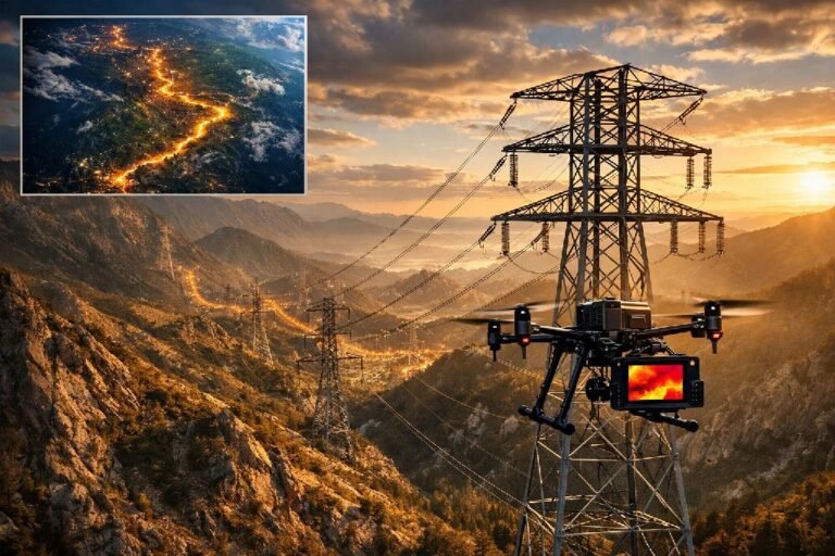
Vegetation Management: How Satellite AI is Reducing Utility Outages by 20% in 2026
Every year, vegetation causes 23% of all power outages across the United States. Trees grow into power lines. Branches fall during storms. Dead trees collapse without warning. The result: $150 billion in annual outage costs, regulatory fines reaching $1 million per day, and millions of customers left in the dark. For utilities managing thousands of circuit miles, the question is no longer whether to modernize vegetation management programs — it is how fast they can transition from reactive trimming cycles to intelligent, satellite-powered monitoring that prevents outages before they happen.
The traditional approach of sending crews to inspect and trim every three to five years simply cannot keep pace with vegetation growth, extreme weather events, and aging infrastructure. Utilities that have adopted satellite imagery combined with artificial intelligence are now achieving measurable results: 10-20% reduction in vegetation-caused outages, 50% faster identification of hazard trees, and significant improvements in SAIDI and SAIFI reliability indices. This transformation represents the single largest opportunity for utilities to reduce their operations and maintenance costs while dramatically improving grid reliability.
The $30 Billion Challenge: Why Vegetation Management Defines Grid Reliability
The global utility vegetation management market reached $30.18 billion in 2025 and continues growing at 5.64% annually toward a projected $52.24 billion by 2035. In the United States alone, utilities spend approximately $7 billion each year on vegetation programs. This spending has grown from 50% of overhead maintenance budgets in 2015 to 75% in 2020 — and continues rising as extreme weather events become more frequent and regulatory requirements more stringent.
The Economics of Vegetation-Caused Outages
The financial impact of vegetation-related failures extends far beyond trimming costs. When a tree contacts a transmission line, utilities face immediate restoration expenses, potential equipment damage, regulatory scrutiny, and customer compensation claims. The 2003 Northeast Blackout, triggered in part by vegetation contact, affected 50 million people and cost the American economy an estimated $7-10 billion. This single event led directly to the mandatory NERC reliability standards that utilities must now follow.
Modern utilities face a compounding challenge: vegetation management expenses continue rising while budgets remain constrained. More than half of utilities acknowledge that their vegetation management budgets do not meet operational requirements. Meanwhile, the workforce is aging and difficult to replace — 54.4% of workers in vegetation management voluntarily left their positions over the past five years. These workforce constraints make technology adoption not just beneficial but essential for maintaining service reliability.
From Cycle-Based to Risk-Based Management
Traditional vegetation management operates on fixed cycles. Utilities trim every span on a three, four, or five-year rotation regardless of actual risk. A rural corridor with slow-growing species receives the same treatment frequency as a suburban area with fast-growing trees near critical infrastructure. This approach wastes resources on low-risk areas while potentially missing high-risk vegetation that grows faster than the cycle allows.
Risk-based management fundamentally changes this equation. By analyzing actual vegetation conditions through remote sensing, utilities can direct trimming crews to the specific spans that need attention most urgently. One cooperative that switched from cycle-based to risk-based management reduced cost-per-mile spending from $2,400 to $500 over six years — an 80% reduction that freed $1 million annually for other infrastructure investments.
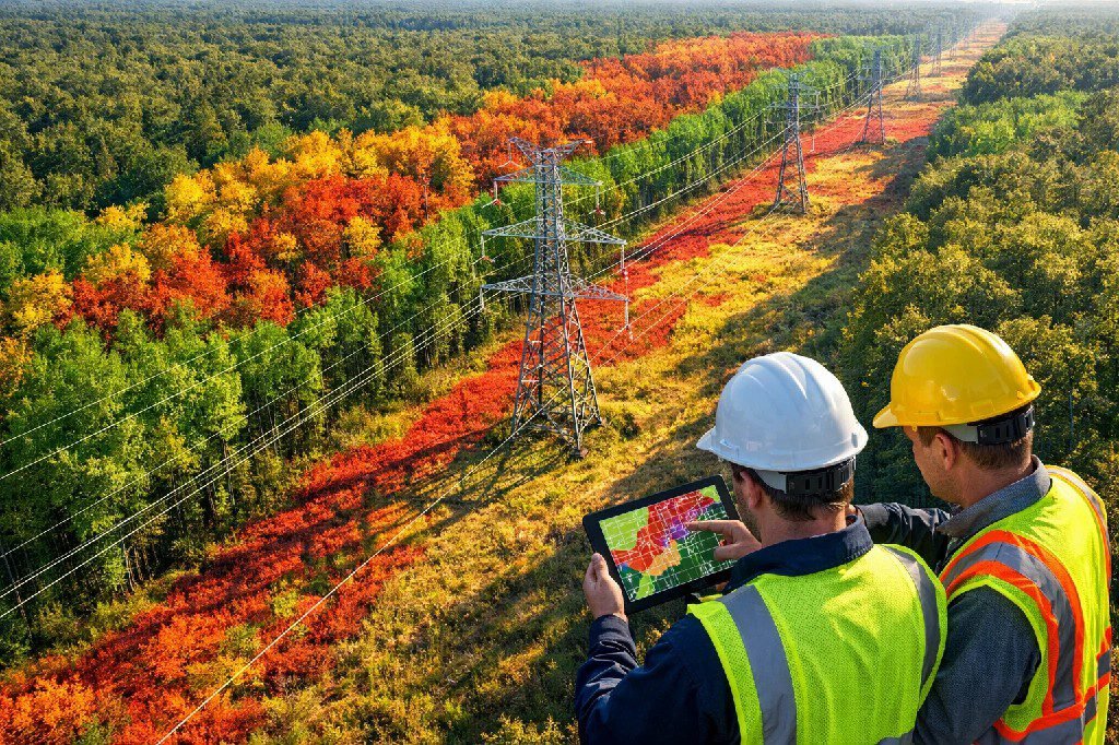
How Satellite and AI Technology Transforms Vegetation Monitoring
Satellite technology has advanced dramatically in recent years. Modern commercial satellites capture imagery at 30-centimeter resolution — detailed enough to identify individual trees, assess canopy density, and detect vegetation health issues. When combined with artificial intelligence, this imagery becomes actionable intelligence that transforms how utilities approach transmission line inspection and right-of-way clearing.
Multi-Spectral Satellite Detection of Encroachment Risks
Satellites capture data across multiple spectral bands, each sensitive to different aspects of the electromagnetic spectrum. Visible light bands reveal tree positions and canopy structure. Near-infrared bands detect chlorophyll content and vegetation health. Shortwave infrared bands identify moisture stress that often precedes tree death. By analyzing these spectral signatures together, AI models can distinguish between healthy vegetation that requires routine monitoring and stressed or dying trees that pose immediate fall-in risks.
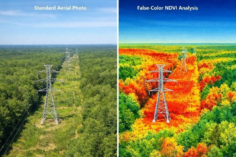
This multi-spectral approach enables detection capabilities that visual inspection cannot match. A tree showing external signs of health may already be dying internally due to disease, root damage, or insect infestation. Spectral analysis reveals these hidden conditions months before they become visible to human observers, providing utilities with critical lead time to remove hazard trees before they fail.
AI Predictive Analytics: Forecasting Growth 12-18 Months Ahead
Artificial intelligence transforms satellite imagery from static snapshots into predictive models. By analyzing historical growth patterns, weather data, soil conditions, and species characteristics, AI algorithms can forecast vegetation encroachment monitoring needs up to 18 months in advance. This predictive capability allows utilities to plan trimming activities proactively rather than reactively.
Predictive analytics engines assign risk scores to individual spans based on multiple factors: current clearance distance, vegetation density, species growth rates, terrain accessibility, wind exposure, and historical outage data. High-risk spans trigger immediate work orders. Medium-risk spans enter monitoring queues for the next scheduled cycle. Low-risk spans can safely extend to longer intervals, reducing unnecessary trimming while maintaining reliability.
The results are measurable. Utilities using AI-powered vegetation management have achieved 10-20% reductions in vegetation-caused outages while simultaneously reducing program costs. One Fortune 500 utility reduced annual outages from over 20,000 to approximately 15,000 — a reduction of 5,000 outages per year — after implementing satellite-based predictive analytics.
Species Identification and Health Assessment
Different tree species grow at vastly different rates and pose different risk profiles. A slow-growing oak may require trimming once per decade. A fast-growing eucalyptus or bamboo may need attention annually. Traditional cycle-based programs treat all species identically, resulting in over-trimming slow growers and under-trimming fast growers.
Advanced AI models can identify specific vegetation species from satellite and aerial imagery. One European transmission operator working with satellite-based vegetation intelligence now classifies 37 different species across their 27,340 miles of transmission lines. This species-level intelligence enables customized trimming schedules that match actual growth patterns rather than arbitrary time intervals.
Hazard tree detection extends beyond simple encroachment monitoring. AI algorithms analyze tree structure, lean angle, canopy asymmetry, and proximity to conductors to identify trees that may fall into lines even without direct contact. These fall-in risks account for a significant portion of vegetation-related outages and are extremely difficult to identify through ground-based inspection alone.
NERC FAC-003-5 Compliance: Meeting Regulatory Requirements with Remote Sensing
The North American Electric Reliability Corporation’s FAC-003-5 standard governs NERC FAC-003 compliance for transmission vegetation management. This standard requires utilities to prevent vegetation encroachments into the Minimum Vegetation Clearance Distance (MVCD) of applicable transmission lines, conduct annual inspections, and maintain documented Transmission Vegetation Management Plans (TVMPs). Violations carry significant penalties — up to $1 million per day for serious infractions.
Minimum Vegetation Clearance Distance Documentation
FAC-003-5 establishes specific clearance requirements based on voltage class and elevation. Utilities must demonstrate that vegetation never encroaches into these MVCD zones under all rated electrical operating conditions, including maximum conductor sag during hot weather. Satellite and LiDAR data provide objective, timestamped documentation of clearance conditions that support regulatory compliance.
Remote sensing creates an auditable record that ground-based inspection cannot match. When regulators request evidence of compliance, utilities with satellite monitoring programs can provide precise measurements showing clearance distances at specific coordinates on specific dates. This documentation capability is particularly valuable when violations are alleged — historical imagery can demonstrate whether vegetation was properly managed before an incident occurred.
Annual Inspection Requirements and Audit Readiness
FAC-003-5 requires that all applicable transmission lines receive vegetation inspection at least annually. For utilities managing thousands of circuit miles, completing these inspections with ground crews alone is logistically challenging and expensive. Satellite-based monitoring supplements ground inspection by providing continuous visibility across the entire network.
The most common root causes of FAC-003 violations involve ineffectively designed TVMPs that fail to address local conditions. Programs that rely too heavily on visual cues, permit inspections at excessive distances, or incorrectly calculate conductor sag and sway under various conditions are particularly vulnerable. Predictive vegetation analytics powered by satellite data help utilities identify these gaps before auditors do.
Struggling with NERC FAC-003 Compliance Documentation?
SkyIntelGroup provides satellite-based vegetation assessments with timestamped, GIS-ready outputs that support your regulatory compliance requirements.
Real-World Results: Utilities Achieving 20% Outage Reduction
The business case for satellite-powered vegetation management is built on documented results from utilities that have made the transition. These case studies demonstrate that the technology delivers measurable improvements in reliability, cost efficiency, and operational effectiveness.
Fortune 500 Utility Case Study
A Fortune 500 electric utility managing over 50,000 circuit miles across multiple states faced a common challenge: fixed trimming cycles spanning four to five years provided minimal predictive capability for preventing outages. Manual data collection left the company reactive rather than proactive, and the sheer scale of their network — millions of customers and an annual vegetation management budget approaching $100 million — made optimization essential.
After implementing satellite-based vegetation intelligence, the utility achieved their best overall customer interruption levels ever recorded. Their vegetation SAIFI goals were met or exceeded every month during the initial implementation period. Most significantly, annual vegetation-related outages dropped from over 20,000 to approximately 15,000 — a reduction of roughly 5,000 outages per year. Beyond reliability improvements, this reduction avoided significant repair costs that compound over time.
The transformation required rethinking their vegetation management approach. Rather than treating every feeder identically, the utility now uses data-driven analysis to evaluate criticality, customer impact, vegetation load, required effort, and outage history for each circuit. This prioritization ensures that limited budgets address the highest-risk areas first.
Cooperative Success Stories
Smaller utilities have achieved equally impressive results. CenterPoint Energy’s Greater Houston Resiliency Initiative, which incorporated LiDAR-based digital twin technology and predictive vegetation modeling, delivered a 50% year-over-year reduction in vegetation-related outage minutes in 2025. This improvement directly enhanced both reliability metrics and customer experience.
Lake Region Electric Cooperative in Minnesota transformed their vegetation management economics completely. Before adopting a systemwide approach supported by data analytics, the cooperative spent approximately $2,400 per mile on vegetation management. Within six years, that cost dropped to $500 per mile — generating approximately $1 million in annual savings that was returned to cooperative members. Their five-year, $7.5 million vegetation management cycle became a four-year, $2 million cycle while simultaneously improving reliability.
Another mid-sized utility managing 5,000 circuit miles with a $25 million annual vegetation budget achieved $4.2 million in annual savings after implementing aerial imagery and predictive analytics. Vegetation-caused outages dropped from 18 per year to 6 per year. Crews completed 25% more planned work orders per field day because they worked from prioritized lists with precise locations rather than surveying entire corridors sequentially.
Satellite vs. LiDAR vs. Helicopter: Technology Comparison for Vegetation Programs
Understanding the strengths and limitations of each remote sensing technology helps utilities select the right approach for their specific needs. Each technology offers distinct advantages depending on coverage area, required precision, budget constraints, and integration requirements.

Cost-Benefit Analysis by Coverage Area
When to Use Each Technology
Satellite imagery excels at scale. For utilities managing tens of thousands of circuit miles, satellite monitoring provides the only cost-effective method for continuous, network-wide visibility. Modern satellite constellations capture imagery at resolutions sharp enough to identify vegetation encroachment risks while covering entire service territories in a single pass. The technology works best for initial risk assessment, change detection between cycles, and ongoing monitoring of previously-identified problem areas.
LiDAR vegetation management delivers precision that satellite imagery cannot match. LiDAR directly measures the distance between vegetation and conductors under current conditions, capturing centimeter-level accuracy in three dimensions. This precision is essential for regulatory compliance documentation where MVCD clearances must be verified. However, LiDAR surveys are expensive and typically conducted annually or less frequently. Many utilities use satellite monitoring for continuous visibility while supplementing with periodic LiDAR surveys for compliance verification.
Helicopter patrols remain valuable for rapid response and visual confirmation of remotely-detected issues. When satellite or LiDAR analysis identifies high-priority hazards, helicopter crews can quickly verify conditions and coordinate immediate response. However, helicopter-only programs are increasingly viewed as insufficient for proactive management. The human eye cannot detect vegetation health issues that spectral analysis reveals, and patrol frequency limitations leave gaps between inspection cycles.
The most effective vegetation management programs combine multiple technologies. Satellites provide continuous monitoring at scale. LiDAR delivers precision clearance measurement. Drones enable targeted inspection of specific problem areas. Ground crews verify remotely-detected issues and execute trimming operations. This integrated approach maximizes the strengths of each technology while minimizing individual limitations.
Implementation Roadmap: From Reactive Trimming to Predictive Management
Transitioning from traditional cycle-based vegetation management to predictive, satellite-powered programs requires systematic planning. The following roadmap outlines a phased approach that minimizes disruption while building toward full predictive capability.
Phase 1: Baseline Assessment
Every effective vegetation management program begins with understanding current conditions across the entire network. Satellite imagery provides this baseline rapidly and cost-effectively. Within weeks, utilities can obtain complete visibility of vegetation conditions along all transmission and distribution corridors — intelligence that would require months or years to gather through ground inspection alone.
The baseline assessment identifies immediate priorities: areas where vegetation already encroaches into clearance zones, corridors with particularly dense growth, and specific hazard trees requiring urgent attention. This initial intelligence allows utilities to direct existing crews to the highest-risk areas immediately, generating value even before predictive models are fully developed.
Phase 2: Risk Scoring and Prioritization
With baseline conditions established, AI algorithms begin analyzing patterns and assigning risk scores. Each span receives a score based on current clearance, vegetation type, growth rate projections, terrain factors, weather exposure, and historical outage correlation. These scores transform raw imagery into prioritized work queues.
Risk scoring enables a fundamental shift in crew deployment. Rather than working sequentially through predetermined routes, crews receive prioritized assignments that maximize risk reduction per field day. High-risk spans receive immediate attention. Medium-risk spans enter scheduled queues. Low-risk spans extend safely to longer cycles, reducing overall trimming volume without increasing outage risk.
Phase 3: Continuous Monitoring Integration
Full predictive capability emerges when satellite monitoring becomes integrated with operational systems. Vegetation intelligence feeds directly into GIS platforms, work management systems, and reliability planning tools. Automated alerts trigger when growth rates exceed projections or when storm damage creates new fall-in risks.
Continuous monitoring transforms vegetation management from a periodic activity into an ongoing process. Rather than inspecting the entire network annually and hoping nothing changes between inspections, utilities maintain real-time awareness of vegetation conditions everywhere. This visibility enables truly proactive management — addressing risks before they cause outages rather than responding after failures occur.
ROI Calculator: Quantifying Your Vegetation Management Savings
Understanding the financial return from satellite-powered vegetation management requires examining both direct cost savings and avoided losses. The following framework helps utilities quantify expected benefits.
Direct Cost Savings
Reduced trimming volume: Risk-based prioritization typically allows 30% of spans to extend safely to four or five-year cycles while another 15% require accelerated 18-24 month cycles. The net effect is reduced total trimming volume without increased outage risk.
Improved crew productivity: Crews working from prioritized lists with precise locations complete 25% more work orders per field day compared to crews surveying corridors sequentially. This productivity improvement directly reduces labor costs per mile managed.
Reduced patrol costs: Satellite monitoring supplements or replaces expensive helicopter patrols. One utility reduced annual helicopter survey costs from $75,000 to $20,000 for targeted problem-area flights after implementing satellite monitoring.
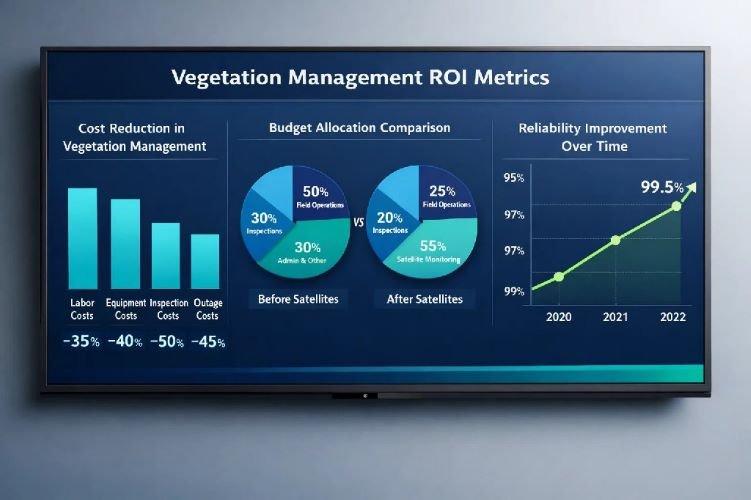
Avoided Outage and Liability Costs
Emergency response savings: Utilities typically experience 30-40% reduction in vegetation-caused emergency callouts after implementing predictive monitoring. At $45,000 average restoration cost per emergency callout, these avoided incidents generate substantial savings.
Regulatory penalty avoidance: NERC FAC-003-5 violations can result in penalties exceeding $200,000 per violation, with serious violations potentially reaching $1 million per day. Documented satellite monitoring programs provide compliance evidence that reduces violation risk.
Wildfire liability reduction: In wildfire-prone regions, vegetation-caused ignitions create existential liability exposure. Pacific Gas & Electric spent $1.4 billion in a single year trimming over one million trees and removing more than 300,000 after wildfire-related liabilities. Proactive satellite monitoring helps identify and address ignition risks before they cause catastrophic losses.
Direct Cost Reduction
15-25%
Average annual vegetation budget savings with risk-based prioritization
Outage Reduction
10-20%
Reduction in vegetation-caused outages reported by utilities using satellite AI
Crew Productivity
+25%
More work orders completed per field day with prioritized routing
How SkyIntelGroup Delivers Vegetation Intelligence for Utilities
SkyIntelGroup provides satellite-based vegetation management services designed specifically for electric utilities. Unlike software-only platforms that require significant internal resources to interpret and act on data, SkyIntelGroup delivers complete analysis with clear recommendations — vegetation intelligence you can use immediately.
Multi-Sensor Integration
Every utility network is different. Some territories feature dense forest corridors. Others cross agricultural land with scattered tree lines. Some regions experience rapid vegetation growth year-round while others have distinct seasonal patterns. SkyIntelGroup integrates satellite imagery, aerial photography, and LiDAR data based on your specific territory characteristics and monitoring requirements.
This flexibility extends to satellite selection. Optical satellites provide detailed imagery under clear conditions. Synthetic Aperture Radar (SAR) satellites penetrate cloud cover for all-weather monitoring. Multi-spectral sensors detect vegetation health issues invisible to standard photography. Rather than limiting clients to a single data source, SkyIntelGroup selects and combines the sensors that best address each utility’s unique challenges.
Custom Risk Models for Your Territory
Generic risk models built on national averages fail to capture local conditions. Vegetation growth rates vary dramatically based on climate, soil, species composition, and microclimate factors. A risk model calibrated for Pacific Northwest conditions would misidentify priorities in Texas or Florida. Effective vegetation management requires models tuned to your specific territory.
SkyIntelGroup develops custom risk models that account for your local conditions: the specific species in your corridors, historical growth patterns in your climate, terrain factors affecting accessibility and wind exposure, and your network’s reliability history. These calibrated models generate prioritization that reflects your operational reality rather than generic assumptions.
GIS-Ready Deliverables
Vegetation intelligence only creates value when it integrates with your operational systems. SkyIntelGroup delivers analysis in formats compatible with your existing GIS platform, work management system, and reliability planning tools. Whether you use Esri ArcGIS, Trimble, or proprietary systems, you receive data ready for immediate integration — no format conversion or manual data entry required.
Deliverables include georeferenced risk assessments, prioritized work lists with precise coordinates, change detection reports highlighting new or increased risks, and compliance documentation supporting NERC FAC-003-5 requirements. All outputs are designed for operational use, not just analysis — actionable intelligence that drives trimming decisions and crew deployment.
Frequently Asked Questions
How quickly can satellite monitoring detect vegetation encroachment compared to traditional inspections?
Satellite constellations can capture imagery of your entire service territory within days and repeat coverage weekly or even daily depending on the constellation used. Traditional ground-based inspection programs typically operate on annual cycles, meaning vegetation changes may go undetected for up to 12 months. Satellite monitoring closes this gap by providing continuous visibility. When combined with AI analysis, new encroachment risks can be identified and prioritized for field response within days of emerging — rather than waiting until the next scheduled inspection discovers them.
Does satellite-based vegetation management replace the need for ground crews?
Satellite monitoring does not replace ground crews — it makes them more effective. Crews still perform all trimming and removal work. The difference is how they receive their assignments. Rather than patrolling corridors looking for problems, crews receive prioritized work lists identifying specific spans requiring attention. This targeted deployment allows crews to complete 25% more work orders per field day because they spend less time searching and more time trimming. The technology transforms crew deployment from patrol-based to precision-based.
What resolution do satellites provide for vegetation assessment?
Modern commercial satellites provide optical imagery at 30-50 centimeter resolution, which is detailed enough to identify individual trees, assess canopy density, and detect changes in vegetation health. For context, this resolution allows analysts to distinguish between different tree species and identify specific hazard trees leaning toward conductors. While this resolution is lower than LiDAR or drone imagery, satellite coverage provides something those technologies cannot: continuous, network-wide visibility at a fraction of the cost.
How does satellite vegetation monitoring support NERC FAC-003-5 compliance?
NERC FAC-003-5 requires utilities to prevent vegetation encroachments into Minimum Vegetation Clearance Distances, conduct annual inspections, and maintain documented Transmission Vegetation Management Plans. Satellite monitoring supports all three requirements. It provides objective, timestamped evidence of vegetation conditions that documents compliance. It supplements annual inspections with continuous monitoring that identifies risks between formal inspections. And it generates the analysis and prioritization data that demonstrates an effectively designed TVMP. During audits, utilities with satellite monitoring programs can provide precise documentation showing clearance conditions at specific coordinates on specific dates.
What is the typical return on investment timeline for satellite vegetation programs?
Most utilities report meaningful results within 18-24 months of implementation. First-year benefits typically include identification of previously unknown high-risk areas, reduction in emergency callouts as predictive models catch encroachments before contact, and improved crew productivity from prioritized routing. By year three, utilities commonly report 15-25% reduction in overall vegetation program costs alongside 10-20% reduction in vegetation-caused outages. The specific timeline depends on starting conditions — utilities with significant deferred maintenance may see faster initial gains as satellite monitoring reveals backlog that ground inspection missed.
Ready to Transform Your Vegetation Management Program?
Get a customized assessment of how satellite-based vegetation intelligence can reduce your outages, lower your costs, and improve NERC compliance documentation.