Sinkhole Detection in Florida: How Satellite Monitoring Identifies Risk Before Ground Collapse
Florida leads the United States in sinkhole activity, with damages exceeding $200 million annually in insurance claims alone. From Tampa to Daytona, the region known as Sinkhole Alley experiences more ground collapses than anywhere else in the country. For property owners, insurers, developers, and government agencies, the threat is constant and the stakes are enormous.
The challenge has always been detection. Traditional methods like Ground Penetrating Radar and geotechnical drilling can identify underground voids, but only after traveling to each individual property and only at that specific moment in time. By the time visible symptoms appear — cracks in foundations, doors that won’t close, depressions in the yard — the subsurface damage has often already progressed significantly.
But there’s a fundamental shift happening in how we approach sinkhole detection in Florida. Satellite-based radar technology can now detect ground deformation at the millimeter scale across vast areas simultaneously. More importantly, it can identify the subtle sinkhole precursors — the gradual subsidence that occurs before catastrophic collapse. Research conducted by Florida International University and the University of South Florida has validated this approach specifically for Central Florida’s challenging suburban environment.
At SkyIntelGroup, we’re bringing this research-validated technology to Florida’s property and infrastructure owners as a commercial service. This article explains how satellite sinkhole monitoring works, why it represents a paradigm shift from reactive to preventive detection, and how different stakeholders can use this intelligence to protect their assets.
Why Florida Is the Sinkhole Capital of the United States
Understanding Florida’s sinkhole problem requires understanding what lies beneath the surface. The geology that makes the state so prone to ground collapse is the same geology that has shaped its landscape for millennia.
The Geology Behind Florida’s Sinkhole Problem
Florida sits atop a foundation of limestone bedrock that extends hundreds of feet below the surface. This carbonate rock is inherently soluble — it dissolves when exposed to slightly acidic water. Rainwater, which becomes mildly acidic as it passes through decaying vegetation and soil, percolates downward and slowly eats away at the limestone over thousands of years.
This process creates karst terrain: a landscape characterized by underground cavities, caves, and conduits carved through the bedrock. The beautiful springs that dot Florida’s landscape are surface expressions of this karst system. But so are sinkholes.
The Florida Geological Survey classifies sinkholes into three main types. Cover-subsidence sinkholes form gradually as sandy soil slowly filters down into limestone voids, creating shallow, bowl-shaped depressions. Cover-collapse sinkholes are far more dramatic — they occur when a clay or sediment layer bridges over an underground cavity until it suddenly gives way, sometimes swallowing entire structures in minutes. Solution sinkholes, the third type, develop in areas where limestone is exposed or only thinly covered, dissolving directly at or near the surface.
The critical factor accelerating sinkhole formation across Florida is groundwater pumping. As water is extracted from underground aquifers for agriculture, industry, and municipal use, the water table drops. This removes the hydraulic support that helps stabilize underground cavities, increasing the likelihood of collapse. Drought conditions compound the problem, which is why Florida often sees spikes in sinkhole activity during dry periods followed by heavy rains.
Sinkhole Alley: The Most Active Region
Central Florida experiences more sinkhole activity than any other region in the United States. The corridor stretching from Hillsborough County near Tampa through Pasco County, Hernando County, and up to the Orlando area has earned the nickname Sinkhole Alley for good reason.
According to insurance industry data, 66% of all Florida sinkhole claims between 2006 and 2010 came from just three counties: Hernando, Pasco, and Hillsborough. The Florida Subsidence Incident Report database, maintained by the Florida Department of Environmental Protection, shows thousands of reported incidents clustered in this region, though experts acknowledge the actual number is far higher since many sinkholes in rural or undeveloped areas go unreported.
The top ten counties for sinkhole activity include Marion, Citrus, Lake, Polk, Pinellas, Orange, and Seminole — essentially forming a band across the central peninsula where geological conditions are most favorable for sinkhole development. These areas share a common profile: limestone bedrock at relatively shallow depths, covered by layers of clay and sandy sediments that can bridge cavities until sudden failure.
What makes this particularly concerning is that these same counties have experienced rapid population growth and urban development. More structures built on karst terrain means more potential victims when the ground gives way. The February 2026 sinkhole that opened on Empire Church Road in Groveland required an estimated $2.6 million in repairs — and that was just for a single roadway, not counting any impact to surrounding properties.
Florida Sinkhole Risk Zones
Zone I — Bare Limestone
South Florida, Keys region. Limestone exposed or thinly covered. Broad, shallow sinkholes develop gradually through direct dissolution.
Zone II — Sandy Cover
30-200 ft of permeable sand over limestone. Few sinkholes, small diameter, gradual development. Cover-subsidence type dominates.
Zone III — Clay Cover (HIGH RISK)
30-200 ft of cohesive clay sediments. Most numerous sinkholes, varying sizes, develop abruptly. Cover-collapse sinkholes dominate. Includes Sinkhole Alley.
Zone IV — Deep Cover
Cover exceeds 200 ft with interlayered carbonates. Few sinkholes but can be large diameter and deep. Cover-collapse type when they occur.
Traditional Sinkhole Detection Methods and Their Limitations
For decades, Florida property owners and engineers have relied on a toolkit of ground-based technologies to investigate sinkhole risk. Each method has its applications, but all share fundamental limitations that satellite technology can now address.
Ground Penetrating Radar (GPR)
GPR surveys are the most common method for sinkhole investigation in Florida. The technology works by transmitting radar pulses into the ground and measuring reflections from subsurface features. Changes in soil density, voids, and water content create distinct patterns in the radar returns that trained geologists can interpret.
Professional geologists typically conduct GPR surveys by pulling an antenna across the ground surface, either manually or behind a vehicle. The equipment produces a cross-sectional image of subsurface conditions, revealing anomalies that may indicate sinkhole activity or underground voids.
The limitation is coverage. A GPR survey examines one property at a time, one pass at a time. For a typical residential lot, costs range from $3,000 to $8,000. Larger commercial properties or detailed investigations can run $15,000 or more. This makes comprehensive area-wide assessment economically impractical — you simply cannot GPR survey an entire county or even a large subdivision.
More fundamentally, GPR provides a snapshot in time. It tells you what exists underground at the moment of the survey, but nothing about whether conditions are stable or actively deteriorating. A void detected today might have been present unchanged for decades, or it might be rapidly expanding. GPR alone cannot distinguish between the two scenarios.
Geotechnical Drilling and Soil Testing
When GPR or visual symptoms suggest possible sinkhole activity, geotechnical engineers often recommend subsurface exploration through drilling. Standard Penetration Tests (SPT) and Cone Penetration Tests (CPT) involve driving sampling equipment into the ground to assess soil properties at various depths.
Drilling provides direct physical evidence of subsurface conditions — you’re actually extracting and testing the material rather than interpreting remote signals. This makes it valuable for confirming suspected problems and designing remediation strategies.
However, drilling is invasive, time-consuming, and expensive. A comprehensive geotechnical investigation with multiple boreholes can cost $10,000 to $50,000 or more depending on site size and complexity. Each borehole only samples a small cylinder of material, so coverage depends on how many holes you’re willing to drill. And like GPR, drilling captures conditions at a single point in time.
Electrical Resistivity Tomography (ERT)
ERT measures how electrical current flows through the ground, creating images of subsurface resistivity variations. Since different materials conduct electricity differently — saturated soil versus dry soil versus air-filled voids — ERT can help identify anomalies associated with sinkhole development.
The technique requires installing arrays of electrodes across the survey area, limiting it to relatively small sites where physical access is available. It’s often used in combination with GPR to provide complementary information, since the two methods are sensitive to different subsurface properties.
The Core Problem with Reactive Detection
All traditional sinkhole detection methods share a fundamental limitation: they are reactive rather than proactive. Property owners typically commission surveys only after observing warning signs — foundation cracks, sticking doors, depressions in the yard, or structural damage that insurance adjusters are investigating.
By the time symptoms become visible, subsurface processes have often been active for months or years. The soil has been raveling into voids, support has been gradually lost, and the structure has already begun to deform. Detection at this stage confirms a problem exists but does little to prevent the damage that prompted the investigation.
What’s been missing in Florida’s sinkhole management toolkit is the ability to monitor ground stability continuously across large areas and identify problems in their earliest stages — before visible symptoms develop and before collapse becomes imminent. This is precisely what satellite-based monitoring now makes possible.

Satellite-Based Sinkhole Detection in Florida: The Technology You’ve Been Missing
A new approach to sinkhole detection in Florida is emerging that addresses the fundamental limitations of ground-based methods. Satellite radar technology can monitor ground stability across vast areas simultaneously, detecting the subtle movements that precede catastrophic collapse.
How InSAR Technology Detects Ground Movement
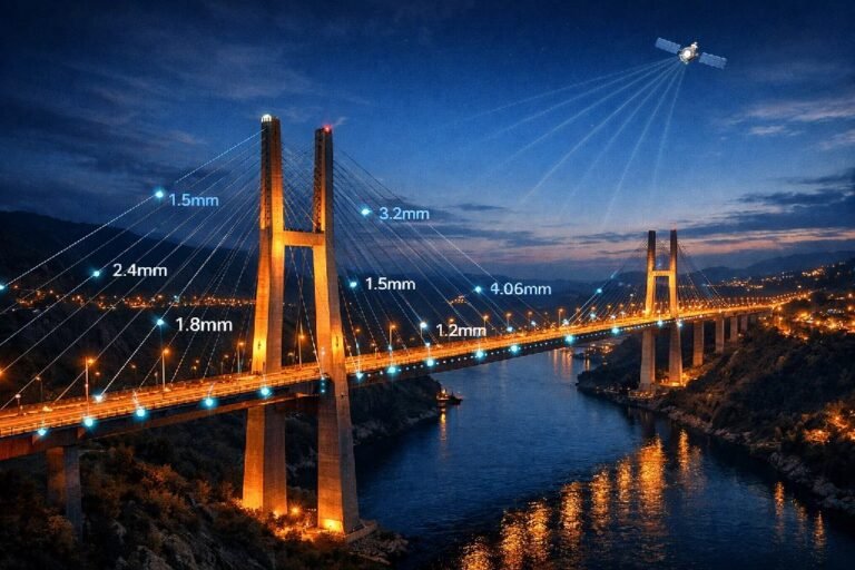
InSAR — Interferometric Synthetic Aperture Radar — is a remote sensing technique that measures changes in the Earth’s surface with extraordinary precision. Satellites equipped with radar sensors orbit the Earth, transmitting microwave pulses toward the ground and recording the reflected signals.
The key insight behind InSAR is that radar waves have a property called phase — essentially, where they are in their oscillation cycle when they return to the satellite. When the same area is imaged on different dates, any movement of the ground surface between acquisitions causes a measurable shift in the phase of returning signals. By comparing images taken weeks or months apart, scientists can calculate exactly how much the ground has moved.
The precision is remarkable. Modern InSAR analysis can detect ground deformation as small as a few millimeters per year. This is movement invisible to the human eye, undetectable by walking across a property, but clearly measurable from space. Over time, patterns emerge: areas of gradual subsidence, zones of stability, and locations where movement is accelerating.
Satellite radar has another crucial advantage — it operates regardless of weather or time of day. Radar penetrates clouds and works in darkness, providing consistent monitoring capability that optical satellites cannot match. For Florida, where afternoon thunderstorms are a daily occurrence much of the year, this all-weather capability is essential for reliable monitoring.
Detecting Sinkhole Precursors Before Collapse
The most valuable aspect of satellite monitoring for sinkhole risk is its ability to identify sinkhole precursors — the ground movements that occur before visible problems develop or catastrophic collapse occurs.
Sinkholes do not appear instantaneously from stable ground. In most cases, subsurface erosion has been progressing for extended periods, gradually undermining support for the surface layer. As voids grow and soil ravels into cavities, the surface begins to subside — often imperceptibly at first, then more rapidly as the collapse approaches.
Research published in Remote Sensing of Environment by scientists from Florida International University and the University of South Florida demonstrated this precursor detection capability specifically for Central Florida sinkholes. Using high-resolution radar data from the TerraSAR-X satellite, they identified localized subsidence monitoring signatures at rates of -3 to -6 millimeters per year in Hernando County and Pasco County.
When researchers conducted ground-truthing at these satellite-identified locations using GPR and visual inspection, they confirmed the subsidence was associated with active sinkhole processes. In other words, the satellite successfully flagged locations where sinkhole activity was occurring — locations that might not have been investigated otherwise because no visible symptoms had yet appeared.
Professor Shimon Wdowinski of FIU summarized the findings: «Our research shows that with special radar satellite technology, we can monitor large areas for localized subsidence and provide highly valuable warning information that could protect people and their property.»
Coverage at Scale: Monitoring Thousands of Properties Simultaneously
Perhaps the most transformative aspect of satellite sinkhole monitoring is the scale at which it operates. A single satellite pass can image thousands of square kilometers, capturing ground movement data for entire counties in one acquisition.
Consider the implications. Rather than investigating properties one at a time after problems appear, satellite monitoring enables proactive surveillance across an entire region. Insurance companies can screen portfolios of thousands of properties. County governments can monitor all public infrastructure continuously. Developers can assess large land parcels before committing to purchase.
The Sentinel-1 satellite constellation operated by the European Space Agency has been collecting radar imagery globally since 2014. This archive means that for any location in Florida, we can analyze more than a decade of historical ground deformation data. If a property has been subsiding gradually over the past ten years, that pattern is encoded in the satellite archive and can be extracted through careful analysis.
This historical perspective is impossible to obtain any other way. You cannot go back in time to conduct a GPR survey from 2015. But you can analyze satellite data from 2015, and 2016, and every acquisition since, building a complete timeline of ground movement at any location of interest.
The cost economics also shift dramatically at scale. While a single-property satellite analysis might not be cheaper than a GPR survey, monitoring a portfolio of 1,000 properties via satellite costs a small fraction of what 1,000 individual GPR surveys would require. For organizations managing risk across many assets — insurance companies, property managers, municipalities — satellite monitoring offers coverage that would be economically impossible with ground-based methods alone.
Protect Your Florida Property Portfolio
For insurance companies, property managers, and REITs with assets across Central Florida, satellite monitoring provides the only practical way to assess sinkhole risk across your entire portfolio. Identify high-risk properties before claims occur.
Who Benefits from Satellite Sinkhole Monitoring in Florida
The ability to monitor ground stability across large areas opens applications for multiple stakeholders, each with distinct needs and use cases. Understanding who benefits — and how — helps clarify the practical value of satellite-based sinkhole risk assessment.
Insurance Companies and Underwriters
Florida is one of only two states requiring insurers to offer sinkhole insurance coverage. This regulatory environment, combined with the state’s high incidence of sinkhole claims, creates significant exposure for property insurers operating in the market.
Traditional underwriting relies heavily on location-based risk models and, in some cases, pre-policy inspections. But inspecting every property before issuing coverage is economically impractical, and location-based models often lack the granularity to distinguish between neighboring properties with very different actual risk profiles.
Satellite monitoring offers insurers a fundamentally new capability: portfolio-wide screening for active ground movement. Before underwriting a policy, an insurer can check whether the specific property shows any history of subsidence. Across an existing book of business, satellite analysis can identify which properties are currently experiencing movement that might presage future claims.
This intelligence supports better risk selection, more accurate pricing, and earlier intervention when problems develop. Rather than learning about sinkhole activity when a claim is filed, insurers can potentially identify at-risk properties and work with policyholders on mitigation before catastrophic damage occurs.
The average Florida sinkhole claim exceeds $140,000. Preventing even a small percentage of claims through better risk identification represents substantial savings — savings that satellite monitoring costs can’t approach.
County and Municipal Governments
Public infrastructure is just as vulnerable to sinkholes as private property, and the costs of repair fall on taxpayers. When a sinkhole opened on Empire Church Road in Lake County in February 2026, engineers estimated $2.6 million would be needed to stabilize and repair the roadway. That’s $2.6 million from county budgets for a single incident on a road carrying about 1,400 vehicles per day.
Multiply this across the hundreds of miles of roads, bridges, water mains, and sewer lines running through karst terrain in Central Florida, and the infrastructure risk becomes clear. Yet counties have no practical way to monitor all this infrastructure continuously using traditional methods. Periodic inspections catch problems only after they’ve already caused visible damage.
Satellite subsidence monitoring allows county governments to track ground stability along all critical infrastructure corridors simultaneously. Movement detected along a road alignment can trigger targeted investigation before pavement fails. Subsidence near a water main can prompt proactive inspection before a main break compounds the problem.
Several Florida Department of Transportation research projects have explored using various technologies for sinkhole detection along state roadways. Satellite monitoring complements these efforts by providing the broad-area surveillance that ground-based methods cannot achieve efficiently.
Real Estate Developers and Investors
For developers contemplating projects in Florida’s sinkhole-prone regions, site risk assessment is a critical due diligence step. A $50 million development can be catastrophically impaired if sinkholes emerge during or after construction.
Traditional pre-development geotechnical studies include borings and possibly GPR surveys across the site. These investigations are valuable but represent conditions at a single point in time. They cannot reveal whether the site has been experiencing subtle subsidence over the past decade — subsidence that might indicate ongoing processes that will continue after construction.
Satellite historical analysis addresses this gap. By examining the archive of radar imagery covering a prospective development site, we can determine whether any portions of the property have shown movement trends over the past ten years. Stable areas can proceed with confidence. Areas showing historical subsidence warrant additional investigation before committing capital.
This same logic applies to commercial real estate acquisitions. Buyers of existing properties in Central Florida increasingly recognize that sinkhole risk should be part of due diligence alongside traditional environmental and structural assessments. Satellite data provides objective evidence of ground stability history that no other source can offer.
Property Management Companies and REITs
Organizations managing large portfolios of Florida properties face a risk aggregation challenge. Even if the probability of a sinkhole affecting any single property is low, the probability of at least one incident somewhere in a portfolio of hundreds of properties becomes substantial.
Traditional approaches to managing this risk involve periodic physical inspections, responding to tenant reports of symptoms, and maintaining adequate insurance coverage. But inspections are expensive and infrequent, tenant reports come only after problems are visible, and insurance — while necessary — doesn’t prevent the operational disruption and reputational damage that sinkhole incidents cause.
Satellite portfolio monitoring provides continuous surveillance at a cost that makes sense across large property counts. Quarterly or semi-annual screening can identify any properties showing new or accelerating movement, allowing property managers to prioritize inspections and maintenance. This systematic approach replaces reactive incident response with proactive risk management.
Insurance Underwriters
Screen portfolios for active subsidence. Identify high-risk properties before policy issuance. Validate claims with objective satellite evidence.
County Governments
Monitor roads, bridges, and utilities across the jurisdiction. Prioritize maintenance based on detected movement. Prevent costly infrastructure failures.
Real Estate Developers
Assess site stability before land acquisition. Review 10+ years of ground movement history. Protect major capital investments from hidden risks.
Property Managers
Continuous monitoring across large portfolios. Early identification of properties needing inspection. Systematic risk management at scale.
How SkyIntelGroup Delivers Sinkhole Risk Intelligence
Understanding that satellite technology can detect sinkhole precursors is one thing. Turning that capability into actionable intelligence for Florida property stakeholders is another. Our approach at SkyIntelGroup combines advanced InSAR technology processing with practical delivery formats designed for real-world decision-making.
Historical Baseline Analysis
Every sinkhole monitoring engagement begins with understanding what has happened in the past. Using archived satellite radar imagery extending back to 2014, we analyze the complete deformation history for properties or areas of interest.
This historical baseline reveals patterns invisible to any other investigation method. Has the property been perfectly stable for a decade? Has there been slow, steady subsidence? Did movement begin recently, or has it been occurring since before current ownership? These questions have direct implications for risk assessment and cannot be answered without historical data.
For real estate transactions, historical analysis provides buyers with objective evidence of ground stability that supplements traditional due diligence. For insurance underwriting, it reveals whether a property has a track record of movement that standard inspections would miss. For infrastructure managers, it identifies corridors where long-term subsidence trends suggest developing problems.
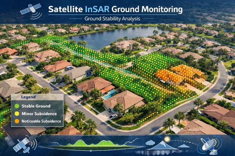
The baseline analysis produces clear visualizations showing movement over time, with measurements expressed in millimeters of vertical displacement. Properties or areas showing concerning patterns are flagged for further investigation, while stable areas can be deprioritized, allowing resources to focus where they’re most needed.
Continuous Monitoring Programs
While historical analysis provides essential context, ongoing monitoring detects new or changing conditions in near-real-time. Our continuous monitoring programs process new satellite acquisitions as they become available, updating ground movement measurements and comparing them against established baselines.
Monitoring frequency depends on satellite revisit rates and client needs. For most applications, monthly or quarterly updates provide sufficient temporal resolution to catch developing problems before they become critical. High-priority assets can be monitored more frequently when satellite coverage permits.
Clients receive regular reports summarizing ground stability across their areas of interest, with alerts triggered when movement exceeds defined thresholds or when acceleration is detected. These alerts enable timely response — scheduling inspections, notifying insurers, or implementing protective measures — before problems escalate.
The monitoring dashboard provides a geographic interface showing all monitored assets with color-coded stability indicators. Users can drill into individual properties to view time-series displacement charts, historical trends, and comparison against regional patterns. This visualization makes complex satellite data accessible to users without remote sensing expertise.
Integration with Ground-Based Verification
Satellite monitoring identifies where ground movement is occurring, but it doesn’t replace the need for on-site investigation to characterize subsurface conditions. The two approaches are complementary: satellites provide broad surveillance and early detection, while ground-based methods provide detailed characterization once a location of concern is identified.
This integration creates a powerful workflow for managing sinkhole risk efficiently. Rather than conducting expensive GPR surveys across entire properties or portfolios, ground investigation can be precisely targeted to locations where satellite data indicates active movement. This focusing effect can reduce ground investigation costs by an order of magnitude while actually improving detection effectiveness.
We work with geotechnical engineering firms throughout Florida who conduct the ground-based follow-up when satellite screening identifies areas of concern. This partnership model ensures that clients have access to complete investigation capabilities — from initial satellite screening through detailed subsurface characterization and remediation design if needed.
Site Assessment Before Construction or Acquisition
Planning a development in Central Florida? Acquiring property in Sinkhole Alley? Our historical analysis reveals ground stability patterns over the past decade, providing due diligence insights that no single-point-in-time survey can match.
The Science Behind Satellite Sinkhole Detection in Florida
The application of InSAR technology to sinkhole detection in Florida rests on solid scientific foundations. Multiple peer-reviewed studies have validated the approach specifically for the challenging conditions found in Central Florida’s suburban karst terrain.
Research Validation: FIU and USF Studies
The most comprehensive validation of satellite sinkhole detection for Florida comes from collaborative research between Florida International University and the University of South Florida, published in the journal Remote Sensing of Environment in 2021.
The research team, led by Professor Shimon Wdowinski of FIU and Professor Sarah Kruse of USF, processed high-resolution radar data from the TerraSAR-X satellite covering three sites in West-Central Florida. They applied Persistent Scatterer Interferometry (PSI) techniques using the Stanford Method for Persistent Scatterers (StaMPS) to identify locations showing coherent ground movement over observation periods of 1.7 to 2.5 years.
The results were striking. Despite the challenging environment — mixed vegetation and construction, small sinkhole features, variable ground cover — the satellite analysis successfully identified multiple areas of localized subsidence. Movement rates at the most active clusters ranged from -3 to -6 millimeters per year, consistent with the gradual subsidence expected from sinkhole precursors.
Critically, the team conducted ground-truthing at satellite-identified locations using GPR and electrical resistivity surveys. These ground investigations confirmed that the subsiding areas were indeed associated with sinkhole activity — validation that the satellite signatures corresponded to real geological processes, not measurement artifacts.
Professor Kruse noted the practical implications: «While we tested the method only in Hernando and Pasco counties, it would also work in Hillsborough and Pinellas Counties, and anywhere else with similar construction and vegetation patterns.» This suggests the approach is applicable across Sinkhole Alley and beyond.
Why Satellite Monitoring Works in Florida’s Suburban Environment
InSAR analysis requires stable radar reflectors on the ground to produce coherent measurements over time. In natural environments with dense vegetation, ground reflectors can be obscured or their signatures can change seasonally, degrading measurement quality. This has historically limited InSAR applications in heavily vegetated areas.
Florida’s suburban landscape, however, provides excellent conditions for InSAR monitoring. Buildings, roads, parking lots, and other constructed features serve as stable persistent scatterers that maintain consistent radar signatures across acquisitions. The mix of structures and vegetation typical of Central Florida neighborhoods provides sufficient reflector density for detailed monitoring while the built environment dominates the radar returns.
The FIU/USF research confirmed this, demonstrating that suburban areas of Hernando and Pasco counties yielded high-quality InSAR results despite being intermixed with vegetation. Subsidence was detected on structures ranging from small residential buildings to larger commercial properties, showing the approach works across property types common in Florida’s sinkhole-prone regions.
Higher-resolution radar satellites like TerraSAR-X and COSMO-SkyMed provide pixel sizes of one meter or less, enabling detection of localized subsidence features that coarser sensors might miss. This resolution is important for Florida sinkholes, which tend to be smaller in surface expression than subsidence features in some other geological settings.
Taking Action: Protecting Florida Properties from Sinkhole Risk
Understanding that satellite monitoring can detect sinkhole precursors is the first step. The next is determining how to integrate this capability into practical risk management strategies appropriate for different stakeholders.
For Property Owners and Managers
Property owners in Florida’s sinkhole-prone areas operate under persistent uncertainty. Is your property stable? Has the ground beneath your home or building been slowly subsiding for years? Would you know before problems became visible?
Satellite historical analysis answers these questions with objective data. By reviewing the record of ground deformation at your specific property extending back to 2014, you can determine whether the site has been stable or whether movement has been occurring. For properties showing historical stability, this provides reassurance backed by evidence. For properties showing movement trends, it provides advance warning that allows proactive steps.
Ongoing monitoring extends this protection into the future. Rather than waiting for cracks to appear or doors to stick, continuous satellite surveillance will detect emerging movement as it develops. Early awareness creates options — time to investigate, time to remediate, time to plan — that aren’t available when problems announce themselves through structural damage.
For property managers overseeing multiple assets, the portfolio approach makes monitoring practical at scale. Systematic screening identifies which properties warrant attention and which can be confidently deprioritized, allowing limited inspection resources to focus where they’ll provide the most value.
For Insurance and Financial Institutions
Insurance underwriters and mortgage lenders have always needed to assess property risk, but they’ve lacked tools for evaluating sinkhole exposure beyond general location-based factors. Satellite monitoring provides the property-specific ground stability data that enables truly informed risk decisions.
Pre-underwriting screening can flag properties with active subsidence before policies are issued, supporting better risk selection and pricing. Portfolio analysis can identify existing policies where emerging movement suggests elevated claim probability, enabling proactive engagement with policyholders. Claims investigation can use historical satellite data to establish timelines and validate or challenge reported damage claims.
Financial institutions considering loans secured by Florida real estate face similar risk exposure. A property undermined by sinkhole activity may lose value or become unmortgageable, impairing collateral quality. Satellite sinkhole risk assessment provides lenders with additional due diligence capability for properties in high-risk zones.
For Government and Infrastructure Managers
Public agencies responsible for Florida’s infrastructure face an impossible task using traditional methods: monitoring thousands of miles of roads, bridges, water lines, and sewer mains for the ground movement that precedes sinkhole formation. The geographic scope overwhelms any practical ground-based monitoring program.
Satellite surveillance changes this calculus. Entire counties can be monitored continuously at costs far below what comparable ground-based coverage would require. Movement detected along critical infrastructure triggers focused investigation using traditional methods, directing expensive field resources precisely where they’re needed.
This approach supports both reactive and proactive infrastructure management. When a sinkhole incident occurs, satellite data can reveal whether precursor movement was present — information relevant for understanding causation and potentially for liability questions. Prospectively, routine monitoring identifies developing problems before they cause failures, enabling scheduled maintenance rather than emergency response.
Three Steps to Sinkhole Risk Intelligence
Assess
Historical analysis reveals ground movement patterns over the past decade for your property or portfolio.
Monitor
Continuous satellite surveillance detects new or changing movement with alerts when thresholds are exceeded.
Act
Targeted ground investigation at satellite-identified locations enables efficient response before problems escalate.
Frequently Asked Questions
Can satellites really detect sinkholes before they collapse?
Yes, but with an important clarification. Satellites detect ground movement, not the underground voids themselves. Research conducted in Florida has demonstrated that InSAR technology can identify subsidence rates of -3 to -6 millimeters per year at locations later confirmed to have active sinkhole processes. This gradual subsidence often precedes catastrophic collapse by months or years, providing an early warning window that ground-based methods cannot offer. The key insight is that most sinkholes don’t form instantaneously — they develop through progressive subsurface erosion that causes detectable surface movement before the final collapse event.
How does satellite sinkhole detection compare to GPR surveys?
The two methods are complementary rather than competing. GPR surveys directly image subsurface features and can detect voids, loose soil, and other anomalies at a specific site. However, GPR requires physical presence at each property, costs $3,000-$15,000 per site, and captures conditions at only one moment in time. Satellite monitoring covers thousands of properties simultaneously at a fraction of the per-property cost, provides historical analysis extending back to 2014, and detects ongoing movement rather than static conditions. The optimal approach uses satellite monitoring for broad-area screening and historical analysis, then deploys GPR for detailed characterization at satellite-identified locations of concern.
What areas of Florida are most at risk for sinkholes?
The highest concentration of sinkhole activity occurs in the region known as Sinkhole Alley, extending from Hillsborough County near Tampa through Pasco County and Hernando County into the Orlando area. Between 2006 and 2010, these three counties accounted for 66% of all sinkhole insurance claims in Florida. Other high-activity counties include Marion, Citrus, Lake, Polk, Pinellas, Orange, and Seminole. The Florida Geological Survey divides the state into four zones based on geology, with Zone III (clay cover over limestone at 30-200 feet depth) experiencing the most numerous and most abrupt cover-collapse sinkholes.
How far back can satellite data show ground movement history?
The European Space Agency’s Sentinel-1 satellite constellation has been collecting radar imagery globally since 2014, providing more than a decade of historical data for Florida properties. Higher-resolution commercial satellites like TerraSAR-X and COSMO-SkyMed offer even longer archives in some areas. This historical record enables analysis of long-term ground stability trends that would be impossible to reconstruct any other way — you cannot retroactively conduct a GPR survey from 2015, but you can analyze satellite data acquired that year to understand what ground conditions were like at that time.
Is satellite monitoring a replacement for geotechnical surveys?
No, satellite monitoring complements rather than replaces traditional geotechnical investigation. Satellites excel at broad-area surveillance, historical analysis, and detecting ongoing movement — capabilities that ground-based methods cannot efficiently provide. However, when satellite screening identifies a location of concern, detailed characterization of subsurface conditions still requires ground-based methods like GPR, electrical resistivity tomography, or drilling. The most effective risk management approach integrates both: satellite monitoring to identify where problems exist or are developing, followed by targeted ground investigation to understand the specific situation and design appropriate responses.
What is the cost of satellite sinkhole monitoring compared to traditional methods?
Costs depend heavily on the scope of monitoring. For a single residential property, satellite analysis may cost less than a full GPR survey but doesn’t provide the same subsurface detail. The economic advantage of satellite monitoring emerges at scale: monitoring a portfolio of 100 or 1,000 properties costs a small fraction of what equivalent ground-based surveys would require. For insurance companies, property managers, county governments, or large developers, satellite monitoring provides coverage that would be economically impossible using traditional methods alone. Our team at SkyIntelGroup can provide specific cost estimates based on your particular monitoring needs and geographic scope.
Conclusion
Florida’s sinkhole challenge isn’t going away. The limestone bedrock that underlies the state will continue dissolving, groundwater demands will persist, and development will keep placing more structures and infrastructure at risk. What can change is how we detect and manage that risk.
For decades, sinkhole detection in Florida has been reactive — investigating properties after symptoms appear, assessing damage after collapse occurs. Traditional methods like GPR surveys and geotechnical drilling provide valuable information, but only at the property scale and only at a single point in time. The cost and logistics of these methods make comprehensive area-wide monitoring impractical.
Satellite-based ground deformation monitoring represents a paradigm shift. Validated by peer-reviewed research from Florida International University and the University of South Florida, InSAR technology can detect the millimeter precision movements that precede sinkhole collapse — the sinkhole precursors that announce trouble before catastrophic failure. And it can do this across thousands of properties simultaneously, with historical analysis extending back more than a decade.
At SkyIntelGroup, we’re making this research-validated capability available commercially for the first time in Florida. Whether you’re an insurance company seeking to screen underwriting portfolios, a county government monitoring public infrastructure, a developer conducting pre-acquisition due diligence, or a property manager responsible for assets across Sinkhole Alley, satellite monitoring provides ground stability intelligence that no other approach can deliver.
The technology exists. The science is validated. The question is whether Florida’s property stakeholders will adopt proactive monitoring before the next collapse, or continue managing sinkhole risk reactively, one costly incident at a time.
Ready to Protect Your Florida Assets?
Contact SkyIntelGroup to discuss how satellite sinkhole monitoring can provide the ground stability intelligence you need.