Property Risk Assessment with Satellite Imagery: A Complete Guide for Insurers (2026)
The insurance industry is undergoing a fundamental transformation in how it evaluates property risk. For decades, underwriters relied on a combination of self-reported data, periodic inspections, and regional risk models to price policies and assess exposures. This approach served the industry reasonably well in an era of relatively stable weather patterns and slower rates of change. That era is over.
Today, insurers face an unprecedented convergence of challenges. Climate change has intensified the frequency and severity of weather events. Construction costs have skyrocketed. Fraud schemes have grown more sophisticated. And policyholders expect faster, more transparent service than ever before. Against this backdrop, the traditional methods of property risk assessment have proven inadequate, leaving insurers exposed to losses they never anticipated and pricing errors that erode profitability.
Satellite and aerial imagery insurance solutions have emerged as the definitive answer to these challenges. By capturing high-resolution images of properties from above, insurers can now verify conditions, identify hazards, and monitor changes across entire portfolios without setting foot on a single property. The technology has matured rapidly, with artificial intelligence enabling automated analysis at scale and regulatory frameworks evolving to accommodate these new capabilities.
This guide provides insurance professionals with a comprehensive understanding of how satellite-based property risk assessment works, why it has become essential for competitive underwriting, and how leading carriers are implementing these solutions to reduce loss ratios and improve operational efficiency. Whether you are evaluating vendors, building a business case, or seeking to optimize an existing program, the insights that follow will help you navigate this rapidly evolving landscape.
The Hidden Cost of Outdated Property Risk Assessment
The property insurance industry faces a silent crisis that costs billions annually. While insurers have access to more data than ever before, the uncomfortable truth is that most of this information is outdated, unverified, or simply wrong. The consequences ripple through every aspect of the business, from mispriced policies to unexpected catastrophic losses.
Why 90% of Insurers Are Working with Unreliable Data
According to recent industry analysis, approximately 90% of home insurers are working from outdated and unverified data sets that focus on broad regional risk factors rather than property-level intelligence. This fundamental gap creates a dangerous blind spot in property risk assessment processes.
The problem begins with how property data is collected. Self-reported information from policyholders and agents has long been the standard, but this approach is inherently flawed. When agents know that an insurer’s pricing becomes significantly more expensive at roof age 10, some will report the roof age as 9 to secure better rates for their clients. The result is a systematic underreporting of actual roof ages across the industry.
Permit data, often considered a reliable third-party source, presents its own challenges. Not all roof work requires permits, and even when permits are filed, there is no guarantee the work was ever completed. This creates a false sense of accuracy that can lead to significant underwriting errors.
The operational impact is equally concerning. Underwriters spend approximately 41% of their time on administrative and operational activities rather than actual underwriting analysis. With this burden, as much as 60% of broker submissions are never even reviewed, and only 25% of those that are reviewed go on to become written policies.
The $31 Billion Roof Problem Nobody Saw Coming
The financial consequences of inadequate building risk assessment became starkly clear in 2024. According to Verisk’s Roofing Realities Report, roof repair and replacement costs in the United States totaled nearly $31 billion, representing a 30% increase since 2022. Roof-related line items now make up more than a quarter of all residential claim value.
Wind and hail were the predominant drivers of these losses, accounting for more than half of all residential claims. Perhaps more telling, non-catastrophic wind and hail roof claims increased from 17% to 25% of the total since 2022. This highlights a critical point: the growing impact of everyday weather events, not just major catastrophes, is reshaping the risk landscape.
The fraud dimension compounds these challenges significantly. Insurance fraud in the property and casualty sector costs insurers between $90 billion and $122 billion annually in the United States alone. Roofing repair scams contribute substantially to this figure, with fraudulent claims exploiting the difficulty insurers face in verifying actual property conditions.
Traditional inspection methods offer limited solutions. Ground-level inspections frequently miss signs of roof damage that are not visible from below. Inspectors working on tight schedules often complete dozens of properties in a single day, leaving little time for thorough examination. The cost of sending inspectors to every property is prohibitive, and access restrictions further limit what can be evaluated.

How Satellite and Aerial Imagery Transforms Property Risk Assessment
The emergence of advanced Earth observation technologies has fundamentally changed what is possible in property risk assessment. Insurers now have access to imaging capabilities that provide unprecedented visibility into property conditions, hazards, and changes over time, all without requiring physical site visits.
Optical Imagery for Roof Condition Assessment
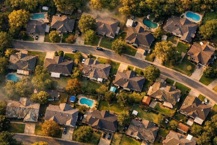
High-resolution optical satellites capture detailed imagery that reveals critical property attributes. Modern commercial satellites achieve ground sample distances of 30 centimeters or better, meaning each pixel represents roughly one square foot of surface area. At this resolution, individual roof shingles, gutters, skylights, and other features become clearly visible.
The value of optical imagery extends beyond simple visualization. Trained analysts and AI algorithms can identify specific conditions that indicate risk, including missing or damaged shingles, ponding water, debris accumulation, vegetation encroachment, and signs of weathering or aging. When combined with historical imagery archives, insurers can track how properties have changed over time and verify when improvements were actually made.
SAR Technology for All-Weather Property Monitoring
While optical imagery provides exceptional detail under clear conditions, Synthetic Aperture Radar technology offers capabilities that optical sensors cannot match. SAR systems emit their own radar pulses and measure the returned signals, enabling them to capture imagery regardless of cloud cover, smoke, or time of day.
For insurers, SAR technology proves invaluable in several scenarios. Following major weather events, when optical satellites may be obscured by clouds for days, SAR can provide immediate damage assessments. The technology also excels at detecting subtle structural changes, including ground subsidence that might indicate foundation problems or shifts in building position that suggest structural stress.
Advanced techniques such as Interferometric SAR and Differential InSAR can measure ground displacement with millimeter-level precision. This capability allows insurers to identify properties at risk from subsidence, landslide, or other geotechnical hazards before damage occurs.
AI-Powered Analysis at Scale
The true breakthrough in geospatial insurance applications came with the integration of artificial intelligence. While satellite imagery has been available for decades, the volume of data generated by modern constellations is far too large for human analysts to process manually. AI changes this equation entirely.
Machine learning models trained on millions of labeled property images can now automatically identify and classify dozens of property attributes. These systems achieve accuracy rates that meet or exceed human performance while processing thousands of properties per hour. The result is a transformation from labor-intensive manual review to automated, scalable property intelligence.
| Technology | Resolution | Weather Dependency | Best Applications |
|---|---|---|---|
| Optical Satellite | 30-50 cm | Clear skies required | Roof condition, vegetation, property changes |
| SAR Satellite | 1-3 meters | All-weather capable | Post-disaster assessment, subsidence monitoring |
| Aerial Imagery | 7-15 cm | Clear skies required | Detailed roof inspection, claims verification |
| InSAR/DInSAR | Millimeter precision | All-weather capable | Ground movement, structural stability |
Five Critical Applications for Insurance Underwriting
Understanding the technology is only the beginning. The real value of satellite-based property risk assessment lies in how insurers apply these capabilities to solve specific business problems. The following applications represent the highest-impact use cases currently deployed across the industry.
Pre-Bind Property Inspection Without Site Visits
The traditional pre-bind inspection creates friction in the underwriting process. Scheduling inspectors, waiting for reports, and managing the logistics of site access all add time and cost to policy issuance. For many carriers, these constraints mean that only a fraction of submissions receive thorough property evaluation before binding.
Remote property inspection through satellite and aerial imagery eliminates these barriers. Underwriters can access current imagery and AI-generated property attributes within seconds of receiving a submission. This capability enables consistent evaluation of every property, not just those that meet minimum premium thresholds or fall within convenient geographic areas.
The business impact is substantial. Carriers report that automated property intelligence enables them to review three to five times more submissions without adding staff. The quality of underwriting decisions improves because every property receives objective evaluation based on current conditions rather than self-reported data.
Roof Condition and Age Verification
Given that roof-related claims now represent more than a quarter of residential claim value, accurate roof condition assessment has become essential for profitable underwriting. Satellite and aerial imagery provide the objective verification that self-reported data cannot.
Modern AI systems can estimate roof age based on visual indicators including shingle granule loss, color fading, moss or algae growth, and visible wear patterns. Some vendors report accuracy rates exceeding 98% when comparing AI-derived roof characteristics against known ground truth data.
Beyond age estimation, imagery analysis reveals conditions that directly impact risk. Ponding water indicates drainage problems that accelerate deterioration. Missing or lifted shingles create immediate vulnerability to water intrusion. Tree branches in contact with roof surfaces cause abrasion damage and provide pathways for pests. Each of these conditions can be identified and flagged automatically.
Hazard Identification and Defensible Space Analysis
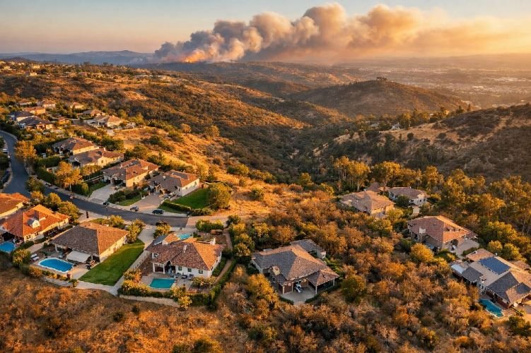
The wildfire risk that has reshaped insurance markets in California and other western states demands more sophisticated hazard assessment than traditional methods provide. Aerial imagery insurance solutions now enable detailed evaluation of defensible space and vegetation management at the individual property level.
AI models analyze imagery to measure the distance between structures and vegetation, classify vegetation types by fire risk, identify combustible materials stored near buildings, and assess roof materials and venting configurations. This granular analysis allows underwriters to differentiate between properties that superficially appear similar but carry very different risk profiles.
The same approach applies to other hazards. Flood risk assessment benefits from precise elevation data and identification of drainage patterns. Wind exposure can be evaluated based on surrounding structures and topography. Each hazard layer adds depth to the overall property risk assessment.
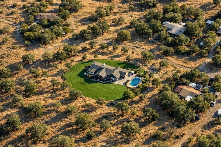
Portfolio-Wide Exposure Assessment
Individual property underwriting represents only part of the opportunity. Satellite imagery enables insurers to assess risk across entire portfolios, identifying concentrations of exposure and properties that may have been underpriced based on outdated information.
Portfolio analytics can reveal patterns invisible at the policy level. Clusters of aging roofs in specific neighborhoods may indicate coordinated replacement opportunities or emerging loss potential. Changes in vegetation patterns across a region might signal shifting wildfire exposure. New construction activity could represent both growth opportunities and evolving risk profiles.
The ability to monitor these dynamics continuously transforms portfolio management from periodic review to ongoing surveillance. Insurers can identify and address emerging risks before they materialize as claims.
Renewal Risk Monitoring and Change Detection
Properties change over time, but traditional underwriting processes often fail to capture these changes until a claim occurs. A homeowner adds a swimming pool, removes mature trees, or allows roof maintenance to lapse. Each change affects risk, but insurers may not discover these conditions until years later.
Satellite-based change detection solves this problem by comparing current imagery against historical baselines. Automated systems flag properties where significant changes have occurred, enabling proactive outreach to policyholders and appropriate premium adjustments at renewal.
This capability also supports fraud prevention. When claimants report damage from recent events, historical imagery provides objective evidence of pre-existing conditions. The technology has proven effective in identifying fraudulent claims where damage preceded the reported cause of loss.
The Regulatory Landscape Insurers Must Navigate in 2026
The rapid adoption of satellite imagery and AI in insurance has attracted regulatory attention. Insurers must understand and comply with an evolving framework of rules that govern how these technologies can be used in underwriting and claims decisions.
California’s Sustainable Insurance Strategy and Catastrophe Modeling
California’s insurance market has been transformed by the Sustainable Insurance Strategy announced in 2024 and implemented beginning in 2025. For the first time, insurers can incorporate forward-looking catastrophe models into their ratemaking, moving beyond exclusive reliance on historical loss data.
This regulatory shift creates new opportunities for satellite-based risk assessment. Carriers can now use advanced modeling that incorporates current property conditions, vegetation changes, and other factors visible through Earth observation. The result is pricing that more accurately reflects actual risk, potentially expanding coverage availability in areas previously considered uninsurable.
However, the California framework also imposes transparency requirements. Insurers must demonstrate the scientific validity of their models and provide clear explanations of how rates are determined. Satellite imagery providers and analytics vendors must be prepared to support these disclosure obligations.
New York’s Push for Aerial Imagery Transparency
New York has taken a different approach, focusing on consumer protection in how aerial imagery is used. Senate Bill S.9156, advanced in 2025, establishes specific requirements for insurers using aerial or satellite imagery in underwriting and claims decisions.
Key provisions include requirements that imagery used for adverse decisions be no more than 180 days old, that insurers provide copies of imagery to policyholders upon request, and that homeowners receive 60 days to remediate identified issues before policy non-renewal. These requirements acknowledge the power of imagery-based assessment while ensuring fairness to consumers.
NAIC Guidelines and State-Level AI Oversight
The National Association of Insurance Commissioners has developed model guidance for AI use in insurance that 23 states have adopted as of early 2026. The NAIC AI Model Bulletin establishes principles including transparency, fairness, and accountability that apply directly to AI-powered property assessment tools.
Insurers using automated property intelligence must ensure their systems do not produce unfairly discriminatory outcomes, even when those outcomes are unintentional. Regular auditing of AI models, documentation of training data and methodology, and human oversight of automated decisions are all elements of compliant implementation.
2024-2026 Insurance Imagery Regulation Timeline
What Leading Insurers Are Doing Differently
The gap between insurers who have embraced satellite-based property risk assessment and those still relying on traditional methods continues to widen. Understanding what leaders are doing differently provides a roadmap for carriers seeking to modernize their approach.
From Reactive to Predictive Underwriting
The most successful implementations share a common characteristic: they have moved beyond using imagery simply to verify information toward using it predictively to identify and price risk before losses occur.
This shift requires integrating property intelligence throughout the underwriting workflow, not treating it as an add-on or exception process. Leading carriers automatically enrich every submission with satellite-derived attributes, applying consistent evaluation standards regardless of premium size or producer relationship.
Predictive underwriting also means using historical imagery to understand risk trajectories. A property where roof condition has deteriorated steadily over several years presents different risk than one where conditions have remained stable. Trend analysis enables more nuanced pricing and earlier intervention.
Real Results: 20% Reduction in Loss Ratios
The financial impact of improved property risk assessment is substantial and measurable. Industry research indicates that insurers implementing advanced predictive modeling reduce loss ratios by 15 to 20 percent compared to those relying on traditional methods.
These improvements come from multiple sources. Better risk selection means fewer policies written on properties with hidden hazards. More accurate pricing ensures premiums match actual exposure. Fraud detection prevents payment of illegitimate claims. Change monitoring enables proactive portfolio management.
The operational benefits compound the financial gains. Faster underwriting decisions improve hit ratios and producer relationships. Reduced inspection costs lower expense ratios. Automated processing frees underwriters to focus on complex risks that benefit from human judgment.
Ready to Transform Your Property Risk Assessment?
Discover how satellite intelligence can reduce your loss ratio and streamline underwriting operations. Our team specializes in delivering actionable property insights for insurers worldwide.
Contact SkyIntelGroup Today →How SkyIntelGroup Delivers Property Intelligence for Insurers
While numerous vendors offer property imagery and analytics, SkyIntelGroup brings a differentiated approach built on deep expertise in satellite remote sensing and geospatial analysis. Our capabilities address the specific challenges insurers face in implementing effective property risk assessment programs.
Satellite-First Approach for Global Coverage
Unlike vendors whose capabilities depend primarily on aerial imagery programs with limited geographic coverage, SkyIntelGroup leverages satellite constellations that provide truly global reach. This distinction matters significantly for insurers with international portfolios or expansion ambitions.
Our satellite-first approach ensures consistent data availability regardless of location. Properties in rural areas, emerging markets, or regions where aerial programs do not operate receive the same quality of analysis as those in major metropolitan areas. This consistency supports standardized underwriting across diverse portfolios.
SAR and InSAR Capabilities Beyond Aerial Limitations
SkyIntelGroup’s expertise in Synthetic Aperture Radar technology provides capabilities that pure optical imagery providers cannot match. Our SAR analysis supports all-weather assessment for post-catastrophe response when optical imagery is obscured. Our InSAR and DInSAR services detect ground subsidence and structural movement with millimeter precision, identifying risks invisible to optical sensors.
These capabilities prove particularly valuable for commercial property assessment, where structural stability and ground conditions significantly impact risk. Insurers gain insights that inform both underwriting decisions and loss control recommendations.
Expert Interpretation, Not Just Raw Data
Technology alone does not solve business problems. SkyIntelGroup combines advanced sensing capabilities with experienced analysts who understand both geospatial science and insurance applications. Our deliverables provide clear, actionable intelligence rather than raw data requiring further interpretation.
This expertise extends to custom analysis addressing specific underwriting questions. Whether evaluating a complex commercial risk, assessing catastrophe exposure across a portfolio, or investigating suspicious claim patterns, our team delivers answers rather than just images.
Global Satellite Coverage
Access property intelligence anywhere in the world with consistent quality and rapid delivery times.
SAR & InSAR Analysis
All-weather imaging and millimeter-precision ground movement detection for comprehensive risk assessment.
Expert Analysis
Experienced geospatial professionals deliver actionable insights tailored to your underwriting requirements.

Getting Started with Satellite-Based Property Risk Assessment
Implementing satellite-based property risk assessment requires thoughtful planning but need not be overwhelming. The following framework helps insurers move from evaluation to implementation efficiently.
Defining Your Assessment Requirements
Successful implementation begins with clarity about business objectives. Consider which underwriting decisions would benefit most from improved property intelligence. Identify the specific attributes and hazards most relevant to your book of business. Determine whether you need point-in-time assessments, ongoing monitoring, or both.
Geographic scope matters as well. Carriers writing primarily in areas with robust aerial imagery coverage face different vendor choices than those with significant rural or international exposure. Understanding your geographic requirements helps narrow the field of potential solutions.
Integration requirements deserve early attention. How will property intelligence flow into existing underwriting systems? What format and delivery mechanisms best support your workflows? Addressing these questions early prevents implementation delays later.
Integration with Existing Underwriting Workflows
The highest-value implementations embed property intelligence directly into underwriting workflows rather than treating it as a separate process. This integration requires cooperation between underwriting leadership, IT, and vendor partners.
Modern property intelligence platforms offer API connectivity that enables automated enrichment of submissions. When an application arrives, the system automatically retrieves current imagery and derived attributes, presenting this information alongside traditional data elements. Underwriters make decisions with complete information without requiring extra steps.
For carriers not ready for full automation, workflow integration can begin more simply. Providing underwriters with easy access to imagery and reports through existing systems captures much of the value while organizational processes mature.
Frequently Asked Questions About Property Risk Assessment
How accurate is satellite imagery for roof condition assessment compared to physical inspections?
Modern AI-powered analysis of high-resolution satellite and aerial imagery achieves accuracy rates exceeding 98% for key roof attributes when compared against ground truth data. While physical inspections can identify some conditions not visible from above, satellite-based assessment provides consistent, objective evaluation at scale that physical inspections cannot match economically. The technology excels at identifying missing shingles, ponding water, debris accumulation, and signs of weathering that indicate elevated risk.
Can satellite imagery be used for claims verification, or only underwriting?
Satellite imagery supports the full insurance lifecycle including claims verification. Historical imagery archives enable comparison of pre-loss and post-loss conditions, providing objective evidence of damage extent and identifying pre-existing conditions. This capability proves particularly valuable for fraud detection and accurate reserve setting. Insurers using satellite-based claims verification report significant reductions in fraudulent payouts and faster claims resolution times.
What is the typical turnaround time for satellite-based property assessments?
Standard assessments using existing imagery archives can be delivered within 24 to 48 hours. For properties requiring new image capture, timelines depend on satellite tasking availability and weather conditions but typically range from 3 to 10 days. Emergency post-catastrophe assessments can often be accelerated through priority tasking arrangements. Compare this to traditional inspection scheduling that may require weeks to coordinate site visits.
How does satellite-based assessment address regulatory requirements for transparency?
Leading providers maintain detailed documentation of imagery sources, capture dates, and analytical methodologies. This documentation supports compliance with emerging regulations requiring disclosure of how imagery-based decisions are made. States like New York now require that imagery used for adverse decisions be no more than 180 days old, and insurers must provide copies to policyholders upon request. SkyIntelGroup maintains comprehensive audit trails that satisfy these regulatory requirements.
What differentiates SkyIntelGroup from other property intelligence providers?
SkyIntelGroup combines satellite-first global coverage with specialized capabilities including SAR and InSAR analysis that most competitors cannot provide. While aerial imagery providers are limited to specific geographic coverage areas, our satellite approach delivers consistent data quality anywhere in the world. Our team brings deep expertise in both remote sensing technology and insurance applications, delivering expert interpretation rather than just raw data. This combination enables comprehensive property risk assessment that addresses risks invisible to optical-only providers.
Transform Your Property Risk Assessment Today
SkyIntelGroup delivers satellite-based property intelligence that helps insurers reduce loss ratios, detect fraud, and streamline underwriting operations. Whether you need a pilot program or enterprise-wide implementation, our team is ready to help.