Pipeline Leak Detection: Satellite vs. Traditional Methods for Oil & Gas Operations
The financial impact of undetected pipeline leaks extends far beyond cleanup costs. According to the U.S. Energy Information Administration, pipeline incidents cost operators over $500 million annually in repairs, lost product, and operational downtime. With the EPA’s methane fee reaching $1,500 per metric ton in 2026 under the Inflation Reduction Act, the economics of leak detection have fundamentally shifted from optional improvement to operational necessity.
For decades, pipeline operators relied on a patchwork of ground patrols, manned aircraft flyovers, and computational monitoring systems to identify leaks. While these methods remain valuable, they share common limitations: restricted geographic coverage, weather dependency, and the inability to detect small leaks before they escalate into environmental disasters. The landscape changed dramatically in July 2025 when the Pipeline and Hazardous Materials Safety Administration (PHMSA) issued a Direct Final Rule officially recognizing satellite-based monitoring as an equivalent method for right-of-way patrols.
This article provides a comprehensive comparison of pipeline leak detection technologies, examining the capabilities, limitations, and optimal use cases for both traditional and satellite-based approaches. The goal is to equip pipeline operators, HSE managers, and integrity engineers with the technical knowledge needed to build a detection strategy that minimizes risk while maximizing regulatory compliance.
The True Cost of Undetected Pipeline Leaks in 2026
Pipeline failures create a cascade of financial consequences that extend well beyond the immediate incident. Corrosion remains the dominant cause, responsible for approximately 60% of all pipeline failures according to industry research. When a leak goes undetected, the costs multiply exponentially with each passing day.
The direct costs include lost product, emergency response, environmental remediation, and infrastructure repair. However, the indirect costs often prove more damaging: regulatory fines, legal liability, insurance premium increases, and reputational harm that affects stakeholder relationships for years.
Consider a documented case from a major pipeline operator in Texas. A leak from an underground crude oil pipeline went undetected for approximately eight months using conventional monitoring methods. When satellite-based vegetation analysis was retroactively applied to the same corridor, the technology identified the leak location and estimated it could have detected the anomaly within weeks of onset. The operator calculated that early detection would have reduced remediation costs by over 93% and prevented months of environmental exposure.
The regulatory environment has intensified this financial pressure. Under current EPA rules, methane emissions from oil and gas operations face escalating fees: $900 per metric ton in 2024, $1,200 in 2025, and $1,500 in 2026 and beyond. For a single super-emitter releasing 100 kg/hr continuously, annual penalties could exceed $1.3 million before accounting for cleanup or legal costs.
Traditional Pipeline Leak Detection Methods: Capabilities and Limitations
Traditional leak detection services have evolved significantly over decades of operational experience. Each technology addresses specific aspects of pipeline integrity, and understanding their individual strengths helps operators build comprehensive monitoring programs.
Computational Pipeline Monitoring (CPM) and SCADA Systems
Supervisory Control and Data Acquisition (SCADA) systems form the backbone of modern pipeline operations. These pipeline monitoring systems collect real-time data from pressure sensors, flow meters, and temperature gauges distributed along the pipeline network. Computational Pipeline Monitoring algorithms analyze this data stream to identify anomalies that may indicate a leak.
The most common CPM approaches include mass balance methods, which compare inlet and outlet volumes to detect discrepancies, and negative pressure wave detection, which identifies the rapid pressure drop that occurs when product escapes through a breach. Real-Time Transient Modeling (RTTM) creates a digital simulation of expected pipeline behavior and flags deviations from the predicted state.
CPM systems excel at detecting large, sudden leaks. When a significant breach occurs, the pressure drop and volume imbalance trigger immediate alarms. The technology integrates directly with control room operations, enabling rapid valve closure and emergency response.
However, CPM faces inherent limitations with small leaks. Industry analysis indicates that most CPM systems cannot reliably detect leaks below 1-3% of the pipeline’s flow rate. A gathering line moving 10,000 barrels per day might lose 100-300 barrels daily before the system registers an anomaly. Additionally, CPM requires continuous calibration to account for instrument drift, temperature variations, and product composition changes. False alarms from transient operational events can desensitize operators to legitimate warnings.
Fiber Optic Sensing: DTS and DAS Technologies
Fiber optic leak detection represents one of the most precise technologies available for continuous pipeline monitoring. A fiber optic cable installed alongside the pipeline acts as a distributed sensor, detecting changes in temperature, acoustic vibration, or strain along its entire length.
Distributed Temperature Sensing (DTS) exploits the Joule-Thomson effect: when pressurized gas escapes through a leak, it rapidly expands and cools, creating a localized temperature anomaly detectable by the fiber. For liquid pipelines, escaping product at temperatures different from the surrounding soil creates a similar thermal signature. DTS systems can locate leaks with precision of 1-5 meters and detect events within seconds of occurrence.
Distributed Acoustic Sensing (DAS) monitors the vibrational signature along the fiber. Escaping fluid generates characteristic acoustic patterns that differ from background noise. DAS also detects third-party interference, identifying excavation activity or unauthorized access near the pipeline before damage occurs.
The primary limitation of fiber optic systems is deployment. For new construction, installing fiber alongside the pipeline adds minimal cost and creates a permanent monitoring asset. For existing buried pipelines, however, retrofit is often impractical or prohibitively expensive. Each interrogation unit typically monitors 50-70 kilometers of fiber, requiring multiple installations for long transmission lines. The technology also provides no information about conditions beyond the immediate pipeline corridor.
Inline Inspection: Smart PIGs
Inline inspection tools, commonly called smart PIGs (Pipeline Inspection Gauges), travel through the pipeline interior to assess structural integrity. These devices use magnetic flux leakage, ultrasonic testing, or geometric measurement to identify corrosion, cracks, dents, and other anomalies in the pipe wall.
Smart PIGs provide detailed information about pipeline condition that no external monitoring can replicate. They detect metal loss from corrosion before it progresses to a leak, enabling preventive maintenance that avoids failures entirely.
The limitation is operational: inline inspection requires pipeline shutdown or reduced flow, interrupting normal operations. The technology assesses pipeline condition at a single point in time rather than providing continuous monitoring. Operators typically schedule inline inspections at intervals of several years, leaving gaps during which new damage can develop undetected.
Ground and Aerial Patrols
Visual inspection remains a regulatory requirement for many pipeline operators. Under PHMSA regulations, hazardous liquid pipelines must conduct right-of-way patrols 26 times per year, while gas transmission lines require patrols between one and four times annually depending on class location.
Traditional patrols involve ground crews traveling the corridor by vehicle or foot, or pilots conducting visual observation from manned aircraft. Trained personnel look for signs of leakage: dead vegetation, surface staining, unusual odors, or visible product. They also identify encroachment risks: new construction, excavation activity, or erosion that could threaten pipeline integrity.
The World Economic Forum cites patrol costs reaching approximately $619 per kilometer annually for comprehensive ground-based programs. Aerial patrols cover more ground but provide less detailed observation. Both methods depend on favorable weather and daylight conditions. Most critically, visual patrols can only detect leaks that have already manifested surface evidence, potentially weeks or months after the initial breach.
| Detection Method | Location Precision | Detection Time | Coverage | Retrofit Feasibility | Key Limitation |
|---|---|---|---|---|---|
| CPM / SCADA | Low (segment-level) | Minutes to hours | Full pipeline | High | Cannot detect small leaks (<1-3% flow) |
| Fiber Optic (DTS/DAS) | 1-5 meters | Seconds | 50-70 km per unit | Low | Difficult/costly for existing pipelines |
| Inline Inspection (PIGs) | High (centimeters) | N/A (periodic) | Full pipeline interior | Medium | Requires operational shutdown |
| Ground/Aerial Patrols | Visual only | Days to weeks | Limited by personnel | High | Weather dependent, labor intensive |
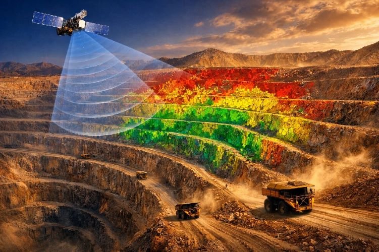
Satellite-Based Pipeline Leak Detection: How Remote Sensing Works
Satellite leak detection leverages multiple sensing technologies to identify pipeline anomalies from orbit. Unlike ground-based methods that monitor the pipeline directly, satellite systems analyze surface conditions that indicate subsurface problems: vegetation stress, soil moisture changes, thermal anomalies, and ground deformation.
Multispectral and Hyperspectral Imaging for Leak Detection
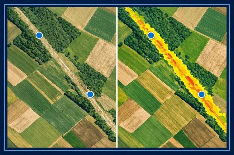
Vegetation health serves as a powerful proxy for detecting underground leaks. When hydrocarbons or produced water escape from a buried pipeline, they alter the soil chemistry in ways that stress or kill surrounding vegetation. This damage often becomes visible to specialized sensors weeks before it appears to the human eye.
The Normalized Difference Vegetation Index (NDVI) quantifies plant health by analyzing how vegetation reflects near-infrared and red light. Healthy plants strongly reflect near-infrared radiation while absorbing red light for photosynthesis. Stressed or dying vegetation shows altered spectral signatures that satellite sensors detect and quantify.
Hyperspectral imaging takes this analysis further by capturing hundreds of narrow spectral bands rather than the handful used in standard multispectral sensors. The Orbital Sidekick GHOSt constellation, for example, captures over 500 bands of light across the electromagnetic spectrum, providing what the company describes as 100 times more spectral information than traditional satellites. This granularity enables detection of specific hydrocarbon signatures and allows analysts to distinguish between different types of contamination.
Hyperspectral sensors operating in the Short-Wave Infrared (SWIR) bands can identify the unique spectral fingerprints of methane, crude oil, and other petroleum products. Rather than inferring a leak from vegetation damage, these sensors can detect the contaminant directly in some conditions.
The practical application is substantial. One satellite operator reported monitoring 124,000 miles of pipeline using hyperspectral technology, identifying suspected methane leaks, liquid hydrocarbon releases, and construction activity that could cause future damage.
Synthetic Aperture Radar for All-Weather Monitoring
Optical and hyperspectral sensors depend on clear skies and adequate lighting. Synthetic Aperture Radar (SAR) overcomes these limitations by actively transmitting microwave pulses and analyzing the reflected signal. SAR operates effectively through clouds, smoke, and darkness, providing consistent monitoring regardless of weather or time of day.
For pipeline leak detection, SAR contributes in several ways. Changes in soil moisture alter how the ground reflects radar signals, potentially indicating subsurface water or hydrocarbon accumulation. L-band SAR, operating at longer wavelengths, can penetrate the ground surface to detect moisture patterns beneath vegetation cover.
Interferometric SAR (InSAR) measures millimeter-scale ground displacement by comparing radar images captured at different times. This capability detects subsidence caused by fluid withdrawal, ground heave from pipeline stress, or slope movement that could threaten infrastructure integrity. Pipelines crossing unstable terrain benefit from continuous deformation monitoring that identifies risks before they cause failures.
SAR also supports encroachment detection by identifying new structures, vehicle tracks, or excavation activity near the right-of-way. The radar signature of metal equipment differs distinctly from natural surfaces, enabling automated detection of heavy machinery operating in the pipeline corridor.
AI-Powered Analytics and Automated Alerting
The volume of satellite data generated by modern constellations far exceeds human analytical capacity. A single high-resolution satellite can capture thousands of square kilometers daily, producing petabytes of imagery across a pipeline network. Artificial intelligence transforms this data deluge into actionable intelligence.
Machine learning algorithms trained on historical imagery learn to distinguish leak signatures from natural variations, seasonal changes, and agricultural activity. These systems flag anomalies for human review while filtering out false positives that would overwhelm response teams. The result is a focused alert stream highlighting genuine concerns.
Modern platforms deliver alerts within hours of satellite overpass rather than the days or weeks required for manual analysis. One provider documented detecting a pipeline leak 13 days before the operator’s conventional methods identified the problem. In another case, retroactive satellite analysis of a known leak site demonstrated detection capability five days earlier than the actual discovery, with estimated savings of millions of dollars in avoided remediation costs.
Integration with existing pipeline monitoring systems allows satellite alerts to flow directly into SCADA interfaces, GIS platforms, and work management systems. Operators receive actionable information in familiar formats rather than navigating separate analytical environments.
Satellite vs. Traditional Methods: A Direct Comparison for Pipeline Leak Detection
Selecting the optimal detection strategy requires understanding how each technology performs across multiple criteria. The following comparison synthesizes operational experience and documented case studies to highlight practical differences.
| Criteria | Satellite Monitoring | Fiber Optic (DTS/DAS) | CPM / SCADA | Aerial Patrols |
|---|---|---|---|---|
| Geographic Coverage | Unlimited | 50-70 km per unit | Full pipeline | Limited by flight time |
| Monitoring Frequency | Daily to weekly | Continuous (24/7) | Continuous (24/7) | Scheduled intervals |
| Small Leak Detection | High (via vegetation) | High | Low | Medium |
| Weather Independence | SAR: Yes | Optical: No | Yes | Yes | No |
| Retrofit Existing Pipelines | No installation required | Difficult / Expensive | Moderate | N/A |
| Encroachment Detection | Excellent | Good (DAS) | None | Good |
| Historical Analysis | 20+ years archive | Since installation | Limited | None |
| Relative Cost per km | Low | High (upfront) | Medium | High (ongoing) |
The comparison reveals that no single technology excels across all criteria. Satellite monitoring offers unmatched geographic coverage and retrofit simplicity but cannot match the instantaneous detection speed of fiber optic systems. CPM provides continuous real-time monitoring but struggles with small leaks that satellites detect through cumulative vegetation impact. Aerial patrols offer flexible deployment but depend on weather and human observation.
PHMSA 2025 Regulatory Update: Satellites Now Officially Approved for ROW Patrols
A significant regulatory barrier fell in July 2025 when PHMSA issued a Direct Final Rule clarifying that satellite-based monitoring satisfies right-of-way patrol requirements under federal pipeline safety regulations. This rule eliminated ambiguity that had discouraged operators from adopting advanced technologies despite their demonstrated effectiveness.
The rule explicitly states that PHMSA’s patrol requirements are «technology neutral» and that remote sensing technologies, including satellites and unmanned aerial systems, can be used for PHMSA compliance purposes. The relevant regulations, 49 CFR §192.705 for gas pipelines and §195.412 for hazardous liquid pipelines, now explicitly accommodate these modern approaches.
Prior to this rule, operators relied on interpretation letters confirming that satellite surveillance could satisfy patrol requirements if it provided «current information and imaging quality comparable to traditional aerial patrols.» While helpful, these letters created uncertainty that made some operators hesitant to shift from conventional methods. The 2025 rule codifies this guidance directly in regulation.
The rule’s preamble notes several advantages of satellite and drone patrols: reduced risk to operator personnel compared with ground or manned aircraft patrols, lower operational costs than traditional methods, and reduced environmental impact from battery-electric propulsion systems. PHMSA expects these regulatory amendments will increase adoption of cost-effective monitoring technologies while maintaining equivalent safety outcomes.
Operators adopting satellite monitoring must document performance equivalence, demonstrating that their remote sensing program detects surface disturbances, excavation, vegetation changes, and other patrol objectives with accuracy comparable to conventional methods. This documentation becomes part of the operator’s pipeline integrity management program and may be subject to regulatory review.
The current patrol frequency requirements remain unchanged: gas transmission pipelines require one to four patrols per calendar year depending on class location, while hazardous liquid pipelines require surface condition inspections at least 26 times each calendar year. Satellite monitoring’s ability to provide daily or weekly coverage easily satisfies these minimum frequencies while providing far more comprehensive oversight than periodic visual patrols.
The Hybrid Approach: Combining Satellite and Ground-Based Systems
Industry experience consistently demonstrates that optimal pipeline leak detection strategies combine multiple technologies rather than relying on any single method. Each approach contributes unique capabilities, and thoughtful integration creates a monitoring program more robust than its individual components.
Satellite monitoring excels at regional screening, continuously observing thousands of kilometers of right-of-way for anomalies that warrant investigation. When satellite analysis detects a potential concern, whether vegetation stress, thermal anomaly, or encroachment activity, ground-based verification follows. This tiered approach focuses expensive field resources on confirmed priorities rather than routine patrol of healthy corridors.
For high-consequence areas (HCAs) where rapid detection is critical, fiber optic systems provide the instantaneous alerting that satellites cannot match. A hybrid strategy might deploy DTS/DAS along pipeline segments near populated areas, water crossings, or environmentally sensitive zones while relying on satellite coverage for remote sections where delayed detection poses less risk.
CPM and SCADA systems maintain their essential role in operational monitoring, detecting large leaks that threaten safety or cause significant product loss. Satellite monitoring complements these systems by identifying small, chronic leaks that fall below CPM detection thresholds but cause cumulative environmental damage and regulatory exposure.
The economic case for hybrid approaches strengthens when considering the $619 per kilometer annual cost of conventional ground patrols. Replacing routine patrols with satellite monitoring while maintaining targeted ground verification for flagged areas can substantially reduce operational costs while improving overall detection capability.
Ready to Upgrade Your Pipeline Leak Detection Strategy?
SkyIntelGroup provides satellite-based pipeline monitoring services that integrate seamlessly with your existing integrity management program. Our solutions help operators detect leaks earlier, reduce patrol costs, and maintain full PHMSA compliance.
ROI and Business Case for Satellite Leak Detection
Quantifying the return on investment for satellite leak detection requires examining both direct cost savings and avoided losses. Documented case studies provide concrete evidence of financial impact.
In a California water utility comparison study, satellite-based leak detection identified over 500 points of interest along approximately 100 miles of pipeline. Field investigation of 146 locations confirmed leaks at 117 sites, an 80% accuracy rate. A competing acoustic correlation method tested simultaneously on the same infrastructure achieved only a 41% confirmation rate. The satellite system’s superior accuracy translated directly into more efficient use of field crew resources.
A pipeline operator in the Eagle Ford shale region engaged retroactive satellite analysis after discovering a chronic leak through conventional means. The analysis demonstrated that satellite vegetation monitoring would have identified the anomaly within weeks of onset, compared with the eight months the leak persisted undetected. The operator calculated payback on a comprehensive monitoring program at approximately 2.11 months based on avoided remediation costs from a single early detection.
Another documented case showed satellite detection 13 days before conventional methods identified an active leak. The early warning enabled response before the release expanded, avoiding escalation into a major environmental incident. Similar scenarios across the industry consistently demonstrate detection advantages measured in days to weeks.
The cost structure of satellite monitoring favors large networks. Unlike fiber optic systems where costs scale with pipeline length, satellite imagery covers extensive areas at relatively flat rates. Operators monitoring thousands of kilometers achieve significant per-kilometer cost advantages compared with patrol-intensive approaches.
Beyond direct savings, satellite monitoring supports regulatory compliance documentation with timestamped imagery archives. When incidents occur, historical imagery establishes baseline conditions and timeline, supporting both internal investigation and regulatory reporting requirements.
Choosing the Right Pipeline Leak Detection Strategy
Selecting the optimal monitoring approach depends on specific operational characteristics. The following framework helps operators evaluate their requirements and match capabilities to needs.
Pipeline type and product influence detection priorities. Gas transmission lines face different risk profiles than crude oil gathering systems or produced water pipelines. Methane leaks from natural gas infrastructure require detection methods sensitive to atmospheric emissions, while liquid hydrocarbon releases manifest through soil contamination and vegetation impact.
Terrain and accessibility determine the relative value of remote monitoring. Pipelines crossing remote wilderness, mountainous terrain, or international borders benefit enormously from satellite coverage that eliminates logistical barriers. Dense vegetation can complicate visual detection while actually enhancing satellite vegetation analysis, since stressed plants contrast strongly against healthy canopy.
Existing infrastructure affects implementation pathways. Pipelines already equipped with fiber optic cables for communications may add DAS/DTS capability with incremental investment. Systems with robust SCADA networks can integrate satellite alerts into existing workflows. Greenfield projects can design hybrid monitoring architectures from inception.
Regulatory environment shapes compliance requirements. Operations in strict regulatory jurisdictions or those facing enhanced scrutiny for environmental performance benefit from the documentation capabilities satellite monitoring provides. The ability to demonstrate continuous oversight addresses both regulatory expectations and stakeholder concerns.
Decision Checklist: Pipeline Leak Detection Technology Selection
- Coverage requirement: Hundreds of km → Satellite | Localized critical zones → Fiber optic
- Detection speed: Seconds required → DTS/DAS | Days acceptable → Satellite + Verification
- Existing pipeline: Buried without fiber → Satellite (no retrofit needed)
- Budget structure: Minimize capex → Satellite subscription | Minimize opex → Fiber optic
- Encroachment risk: High third-party activity → Satellite change detection + DAS
- Environmental sensitivity: HCAs, water crossings → Hybrid with redundant coverage
Frequently Asked Questions About Pipeline Leak Detection
How accurate is satellite-based pipeline leak detection compared to traditional methods?
Field validation studies demonstrate satellite detection accuracy of approximately 80% when vegetation health analysis identifies potential leak locations. This compares favorably with acoustic correlation methods achieving 41% accuracy in side-by-side testing. However, satellite detection typically identifies leaks days to weeks after onset, while fiber optic systems can detect events within seconds. The technologies excel at different aspects of detection rather than directly replacing each other.
Can satellites detect small pipeline leaks that SCADA systems miss?
Yes. Computational Pipeline Monitoring systems typically cannot detect leaks below 1-3% of pipeline flow rate due to instrument uncertainty and noise. Satellite vegetation analysis can identify much smaller chronic leaks because the cumulative impact on plant health becomes detectable even when instantaneous flow changes are too subtle for CPM. One case study documented satellite detection of leaks that persisted undetected by conventional methods for eight months.
Is satellite monitoring PHMSA compliant for right-of-way patrols?
Yes. PHMSA’s July 2025 Direct Final Rule explicitly confirms that satellite-based remote sensing satisfies patrol requirements under 49 CFR §192.705 and §195.412. Operators must document that their satellite monitoring provides detection capability equivalent to traditional patrol methods for surface disturbances, excavation activity, and vegetation changes.
What is the cost of satellite pipeline monitoring per kilometer?
Satellite monitoring costs depend on coverage area, monitoring frequency, and analytical complexity. Unlike ground patrols costing approximately $619 per kilometer annually, satellite costs scale more favorably with pipeline length. Annual subscription services covering extensive networks often achieve per-kilometer costs substantially below conventional patrol programs, with break-even typically occurring within months of detecting a single significant leak early.
How quickly can satellite monitoring detect a pipeline leak?
Detection timing depends on satellite revisit frequency and leak manifestation rate. Modern constellations provide daily imagery of most locations, with alerts delivered within hours of capture. However, leaks must produce detectable surface evidence before satellites can identify them. Vegetation stress may take days to weeks to become spectrally distinct, while visible surface contamination may be detected on the next available image. Fiber optic systems remain superior for immediate detection requirements.
Can satellite monitoring work in cloudy or forested areas?
Synthetic Aperture Radar (SAR) operates independently of weather conditions and illumination, providing consistent monitoring through clouds, smoke, and darkness. Optical and hyperspectral sensors require clear skies but often achieve acceptable revisit rates even in frequently cloudy regions. Forest cover actually enhances vegetation-based detection because stressed trees contrast clearly against healthy canopy. SAR also penetrates vegetation canopy to detect soil moisture changes beneath.
Building a Future-Ready Pipeline Monitoring Program
The evolution of pipeline leak detection technology has created unprecedented options for operators seeking to protect their infrastructure, comply with regulations, and minimize environmental impact. Satellite-based monitoring has matured from experimental technology to a PHMSA-approved compliance method, offering capabilities that complement rather than replace traditional approaches.
The most effective monitoring programs integrate multiple technologies strategically. Satellite coverage provides the macro-level visibility to screen extensive networks efficiently, detecting anomalies that warrant ground investigation. Fiber optic systems deliver instantaneous alerting in critical zones where response time directly affects outcomes. CPM and SCADA maintain their essential role in real-time operational awareness. Together, these layers create defense-in-depth that no single technology achieves alone.
The regulatory environment now supports this technological diversity. PHMSA’s 2025 Direct Final Rule removed barriers to satellite adoption while maintaining performance standards that ensure safety outcomes remain paramount. Operators can confidently invest in remote pipeline monitoring knowing their compliance foundation is secure.
As methane regulations tighten and environmental scrutiny intensifies, early leak detection becomes increasingly valuable. The difference between detecting a release in days versus months often determines whether an incident remains a manageable operational event or escalates into an environmental crisis with lasting financial and reputational consequences.
Get a Custom Pipeline Monitoring Assessment
Our team analyzes your pipeline network, regulatory requirements, and operational priorities to recommend the optimal monitoring strategy. Whether you need satellite-based leak detection, ROW encroachment monitoring, or integrated integrity management support, SkyIntelGroup delivers actionable intelligence from space.