Land Subsidence in California: The $2 Billion Problem Hiding Beneath Your Property
If you own property in California—whether farmland, a housing development, or commercial real estate—there’s a silent threat that could be eroding your investment right now. It’s not an earthquake. It’s not a wildfire. It’s the ground itself, slowly sinking beneath your feet.
Land subsidence in California has already cost property owners nearly $2 billion in lost home values alone. And that number keeps growing every year.
The worst part? Most people don’t realize it’s happening until the damage is done. Cracked foundations. Broken wells. Irrigation systems that no longer work. By then, the problem is irreversible.
But here’s what few people know: you can detect subsidence months or even years before visible damage appears. Satellite technology now measures ground movement with millimeter precision—the same technology that government agencies use to track this crisis across the state.
This guide explains everything you need to know: what’s causing California’s land to sink, which areas are most at risk, what it’s costing property owners, and how you can protect your investment before it’s too late.
What Is Land Subsidence and Why California Leads the Nation
Land subsidence is exactly what it sounds like: the ground sinking. But unlike a sinkhole that opens suddenly, subsidence happens gradually—sometimes just a few inches per year. That might not sound like much, but over a decade, those inches add up to feet. And the damage compounds exponentially.
Here’s a sobering fact: half of all land subsidence in the entire United States has occurred in California. No other state comes close.
Why California? The answer lies beneath the surface.
The Mechanics Behind California’s Sinking Land
The Central Valley groundwater system is one of the largest aquifers in the world. For over a century, farmers and cities have pumped water from this underground reservoir to irrigate crops and supply communities. During drought years, that pumping intensifies dramatically.
The problem is what happens when you remove too much water too quickly.
Deep underground, layers of clay and sand hold the aquifer together. When water is pumped out, these layers lose the pressure that kept them expanded. The clay compresses—permanently. Think of it like squeezing a sponge and never letting it spring back.
This process is called aquifer compaction, and here’s the critical part: it cannot be reversed. Once the ground sinks, it stays sunk. Even if you stop pumping water entirely and the aquifer refills, the land will never rise back to its original level.
That’s what makes subsidence different from other land problems. You can rebuild after a flood. You can replant after a fire. But you cannot undo subsidence. You can only stop it from getting worse—if you catch it in time.
Ground Zero: The Regions Most Affected by Subsidence
Not all of California is sinking equally. The crisis is concentrated in specific areas, and if you own property in these regions, you need to pay attention.
San Joaquin Valley — The Epicenter of American Subsidence
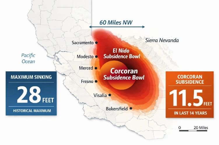
The San Joaquin Valley subsidence problem is unlike anything else in the country. By 1970, significant sinking—more than one foot—had already affected about 5,200 square miles of land. In some spots, the ground had dropped by as much as 28 feet.
And it’s getting worse, not better.
Recent satellite measurements show two main «bowls» where the sinking is most severe. The larger one is centered on Corcoran and extends roughly 60 miles to the northwest. The second is centered on El Nido, spanning about 25 miles in diameter.
Together, these zones represent some of the fastest-sinking land on Earth.
Corcoran and the Alarming Rate of Recent Sinking
The town of Corcoran has become a cautionary tale for what happens when groundwater pumping goes unchecked.
In some areas around Corcoran, the land has sunk 11.5 feet in just 14 years. That’s nearly a foot per year—fast enough to cause serious structural damage to buildings, roads, and water infrastructure.
But even that average understates the problem during drought conditions. NASA’s Jet Propulsion Laboratory recorded one stretch where the ground near Corcoran dropped 13 inches in just eight months. That’s 1.6 inches per month—a rate that can crack foundations, rupture pipelines, and destroy wells in a matter of seasons.
The True Cost of Ignoring Land Subsidence
Subsidence isn’t just an environmental issue or a geological curiosity. It’s a financial disaster that’s already hitting property owners hard.
Property Values in Freefall
A groundbreaking study from UC Riverside put real numbers to what many California property owners have suspected: subsidence is destroying home values.
The research found that homes in subsiding areas lost between 2.4% and 5.8% of their sale value. That translates to losses between $6,689 and $16,165 per home. Multiply that across thousands of affected properties, and the total reaches $1.87 billion in lost housing value across the Central Valley.
And that’s just residential property. Commercial real estate, farmland, and industrial properties face similar or greater losses—losses that often aren’t covered by standard insurance policies.
The cruel irony is that many owners don’t discover their property has been affected until they try to sell. A buyer’s inspection reveals foundation cracks. An appraisal comes back lower than expected. By then, the damage is already baked into the price—and into your loss.
Infrastructure Damage Running Into Billions
While individual property owners suffer quietly, the infrastructure damage from subsidence makes headlines when it hits critical water systems.
The Friant-Kern Canal, which delivers water to over a million acres of farmland, has lost more than 60% of its original capacity in some sections. The ground sank so much that water simply can’t flow as fast anymore. Repairs on just one 10-mile stretch have already cost $326 million, with the total project expected to exceed $1 billion.
The California Aqueduct—which supplies water to 27 million people in Southern California—faces similar problems. During the drought from 2013 to 2016, sections of the aqueduct sank nearly three feet. Three feet in three years.
State and federal agencies have spent an estimated $100 million on subsidence-related repairs since the 1960s—and that covers only the major canals. It doesn’t include the countless private wells that have been damaged, the irrigation ditches that no longer work, the roads that have buckled, or the bridges that now require expensive monitoring.
The Cost of Subsidence: Damage vs. Prevention
💸 Cost of NOT Monitoring
- $1.87 billion in lost property values (Central Valley)
- $1+ billion for Friant-Kern Canal repairs alone
- 2.4% – 5.8% average home value loss
- 60%+ canal capacity loss in worst sections
- Foundation repairs: $10,000 – $50,000+ per property
- Well replacement: $15,000 – $30,000
✅ Cost of Satellite Monitoring
- Fraction of repair costs for annual monitoring
- Millimeter precision detection
- Early warning months before visible damage
- Historical baseline from archived satellite data
- Evidence for insurance claims and legal disputes
- SGMA compliance documentation
Early detection through satellite monitoring can prevent catastrophic losses and provide documentation for regulatory compliance.
SGMA and the Legal Obligation to Monitor Subsidence
If you manage groundwater in California—whether as a water district, a large agricultural operation, or a Groundwater Sustainability Agency—subsidence monitoring isn’t just smart. It’s the law.
What the Sustainable Groundwater Management Act Requires
The Sustainable Groundwater Management Act of 2014 fundamentally changed how California manages its underground water. For the first time, the state required local agencies to develop plans that would bring aquifers into balance—extracting no more water than nature replenishes.
A key part of SGMA compliance is monitoring and preventing «undesirable results,» and land subsidence is specifically listed as one of those results.
Under SGMA, California has designated 21 basins as critically overdrafted basins. These areas must achieve sustainability by 2040, which means demonstrating that subsidence has been stopped or controlled.
The California Department of Water Resources released updated Best Management Practices for land subsidence in January 2026, describing specific practices that local agencies must follow to avoid or minimize sinking.
The Consequences of Non-Compliance
Agencies that fail to meet SGMA requirements face serious consequences. The state can place them on probation and ultimately take over groundwater management—removing local control entirely.
For property owners in these areas, the implications are significant. Groundwater Sustainability Agencies need accurate, ongoing data about subsidence in their jurisdictions. The state’s monitoring program covers regional trends, but it doesn’t provide the property-level detail that many GSAs need to demonstrate compliance.
That’s creating demand for private monitoring services that can fill the gap between what the state provides and what local agencies actually need.
Need Subsidence Data for SGMA Compliance?
Our satellite monitoring delivers the millimeter-precision data that Groundwater Sustainability Agencies need—with historical baselines and quarterly updates that integrate directly into your Groundwater Sustainability Plan.
Get a Free Consultation →Water districts and GSAs across California trust our intelligence for compliance-ready subsidence data.
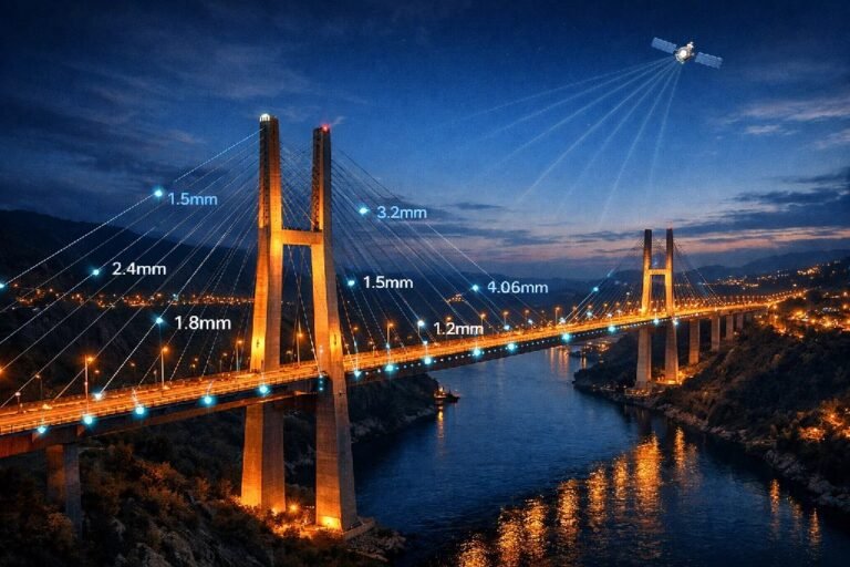
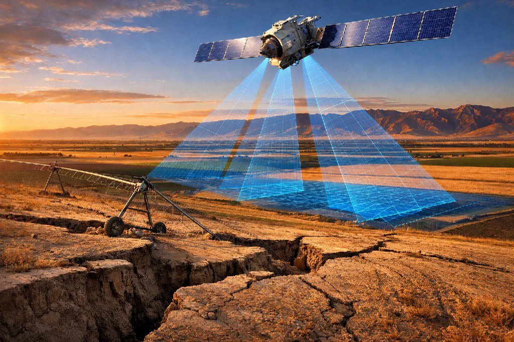
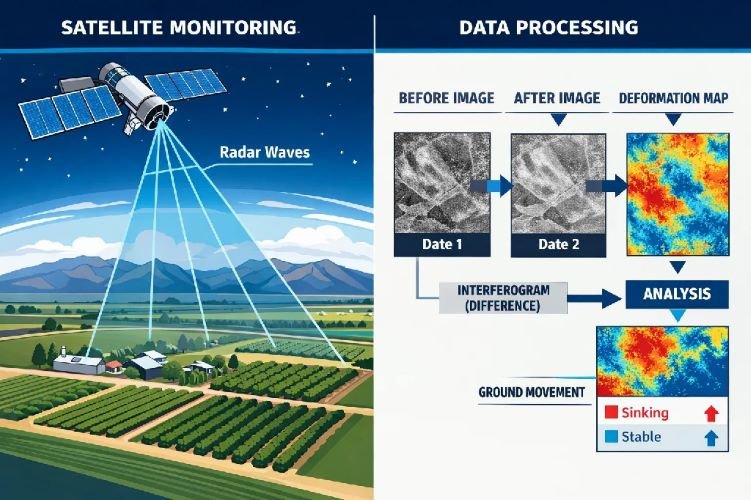
How Satellite Technology Detects Subsidence Before It’s Too Late
Here’s where things get interesting. The same technology that tracks subsidence for government agencies is now available for private property owners, agricultural operations, and local water districts.
InSAR Monitoring Explained
InSAR monitoring—Interferometric Synthetic Aperture Radar—sounds complicated, but the concept is straightforward.
Satellites orbit Earth carrying radar sensors. These satellites send radar signals down to the ground and measure how long the signals take to bounce back. By comparing measurements from different passes over the same area, analysts can calculate exactly how much the ground has moved.
The precision is remarkable: modern InSAR can detect ground movement as small as a few millimeters. That’s far more sensitive than any ground-based measurement system, and it covers vastly larger areas.
Traditional methods—like extensometers buried in the ground or GPS stations—only measure single points. If you have 10,000 acres, you’d need dozens of expensive instruments to get comprehensive coverage. With satellite subsidence monitoring, a single analysis covers your entire property and surrounding areas, revealing patterns that point measurements would miss entirely.
How California Already Uses Satellite Data
The California Department of Water Resources recognized the value of InSAR years ago. They contracted with specialized firms to provide ongoing satellite monitoring across the state’s most affected regions.
Every quarter, these contractors acquire about 2,500 radar satellite scenes covering DWR’s monitoring area. From that data, they produce detailed maps showing subsidence at 100-meter resolution—roughly the size of a football field.
This state-level monitoring serves an important purpose: it tracks regional trends and identifies problem areas. But it has limitations for individual property owners. The state’s program is designed for policy decisions, not property-level risk assessment. It doesn’t tell you what’s happening on your specific parcel, whether your particular well is at risk, or whether the building site you’re considering is stable.
That’s where private monitoring becomes essential.
Why Private Subsidence Monitoring Is Now Essential
The gap between what the state monitors and what property owners actually need is significant—and growing.
The Gap Between State Data and Your Property
Government monitoring programs serve government purposes. They track large-scale trends to inform policy and identify areas that need attention. That’s valuable, but it’s not the same as telling you whether your specific property is sinking.
Consider a large agricultural operation with 5,000 acres. State-level monitoring might show that your general region is experiencing subsidence. But is it affecting your north fields more than your south fields? Is the area around your processing facility stable? Are your wells at risk of casing damage?
The state data won’t answer those questions. Private monitoring will.
The same applies to real estate developers. Before you invest millions in a new project, you need to know the baseline condition of that specific site. «The region has subsidence problems» is not the same as «this parcel has moved 2.3 inches in the past year and shows accelerating trends.»
Who Needs Private Subsidence Monitoring in California
The demand for detailed subsidence data spans multiple sectors:
Groundwater Sustainability Agencies need property-level data to complement regional monitoring. Their Groundwater Sustainability Plans must demonstrate they’re addressing subsidence, and state-provided data alone often isn’t detailed enough for compliance documentation.
Large agricultural operations have millions invested in land, wells, and irrigation infrastructure. Early detection of subsidence can prevent well casing failures that cost $15,000 to $30,000 to repair—or worse, permanent loss of a producing well.
Real estate developers and investors need baseline assessments before acquisition. A property that looks perfect on the surface might be sitting in an active subsidence zone. That information dramatically affects the investment calculation.
Water districts and irrigation districts operate canals, pipelines, and facilities that are directly damaged by ground movement. Continuous monitoring allows them to identify problem areas before catastrophic failures occur.
Insurance companies increasingly want objective data to assess property risk. Satellite monitoring provides the kind of verifiable, third-party documentation that supports underwriting decisions and claims verification.
Geotechnical engineers working on construction projects need historical subsidence data and ongoing monitoring to design foundations and structures that will perform properly over their intended lifespan.
How We Help You Stay Ahead of Subsidence
Our team specializes in satellite subsidence monitoring using the same DInSAR technology that government agencies rely on—but tailored to your specific needs.
Millimeter-Precision DInSAR Analysis
We deliver deformation analysis with millimeter precision, detecting ground movement that’s invisible to the naked eye and far too subtle for conventional surveys to catch.
Because satellite data has been collected for years, we can establish historical baselines for your property—showing how the ground has behaved over time, not just where it is today. This historical perspective is invaluable for understanding trends and predicting future movement.
For ongoing concerns, we provide continuous monitoring with monthly or quarterly updates, depending on your needs. You’ll know immediately if conditions change, giving you time to respond before damage occurs.
What We Deliver
Every project includes comprehensive analysis and documentation designed for practical decision-making:
Deformation maps show exactly where ground movement is occurring across your area of interest. Color-coded visualizations make it easy to identify stable zones and problem areas at a glance.
Time-series analysis tracks how subsidence has evolved over months and years. This reveals whether conditions are stable, worsening, or improving.
Risk assessments identify the areas most likely to experience damage based on current movement patterns and geological factors.
SGMA-ready documentation provides the evidence that Groundwater Sustainability Agencies need for compliance reporting and plan development.
GIS integration means our data works seamlessly with your existing mapping and analysis systems—no awkward format conversions or manual data entry.
What You Get With Satellite Subsidence Monitoring
Deformation Maps
Visual identification of stable zones and problem areas across your entire property
Time-Series Analysis
Historical trends showing how ground movement has evolved over months and years
Risk Assessment
Identification of areas most likely to experience infrastructure damage
Compliance Documentation
SGMA-ready reports for Groundwater Sustainability Plan requirements
GIS Integration
Data delivered in formats compatible with your existing mapping systems
Ongoing Monitoring
Monthly or quarterly updates to track changing conditions in real time
Protect Your California Property Investment
Whether you manage farmland, develop real estate, or oversee water infrastructure, we’ll show you exactly what’s happening beneath the surface—before it becomes a costly surprise.
Request Your Property Assessment →From baseline assessments to continuous monitoring—we deliver the intelligence you need to make confident decisions.
Frequently Asked Questions
How fast is land sinking in California’s worst-affected areas?
In the most severe zones around Corcoran, the ground has sunk more than 11 feet in 14 years—nearly a foot per year on average. During drought conditions, rates can spike dramatically. NASA recorded 13 inches of sinking in just eight months in one area, which works out to about 1.6 inches per month. These rates are fast enough to damage wells, crack foundations, and rupture underground pipelines within a single growing season.
Can land subsidence be reversed?
No. Once aquifer compaction occurs, the ground stays at its new, lower level permanently. Even if pumping stops completely and the aquifer refills with water, the compressed clay layers cannot expand back to their original state. This is why early detection matters so much—the only option is to slow or stop subsidence before more damage accumulates. Prevention through sustainable groundwater pumping practices is the only real solution.
How much does subsidence monitoring cost compared to potential losses?
The cost of satellite monitoring is a tiny fraction of potential losses. Consider that a single well replacement runs $15,000 to $30,000, foundation repairs can exceed $50,000, and the average home in a subsiding area loses $6,000 to $16,000 in value. Meanwhile, satellite subsidence monitoring for an entire property costs far less than any single repair—and can provide years of advance warning before damage occurs. For GSAs facing potential state probation, the cost comparison is even more stark.
Is satellite monitoring accurate enough for SGMA compliance?
Absolutely. The California Department of Water Resources itself uses InSAR monitoring as a primary data source for tracking subsidence statewide. The technology delivers millimeter precision measurements that exceed the accuracy requirements for SGMA compliance documentation. In fact, satellite data often provides better spatial coverage than ground-based monitoring networks, making it ideal for the comprehensive assessments that Groundwater Sustainability Plans require.
How often should I monitor my property for subsidence?
It depends on your situation and risk level. Properties in actively subsiding areas—particularly near Corcoran, El Nido, or other critically overdrafted basins—benefit from quarterly monitoring to catch rapid changes. Properties in lower-risk areas or those establishing baselines may only need annual assessments. For real estate transactions or construction projects, a one-time historical analysis combined with current conditions often provides the necessary due diligence. We can recommend the right frequency based on your specific location and concerns.