Insurance
Advanced Insurance Risk Assessment & Damage Detection Services
Satellite-based property risk assessment, flood monitoring, catastrophe damage detection, and predictive analytics for modern insurance operations
Get StartedComprehensive Insurance Solutions Using Satellite Technology
SkyIntelGroup provides professional insurance risk assessment services powered by advanced satellite remote sensing and AI analytics. Our solutions include property risk assessment, building risk assessment, flood monitoring, and wildfire risk assessment to optimize underwriting, accelerate claims processing, and reduce loss ratios for insurance carriers worldwide.
From catastrophe risk modeling and post-disaster damage detection to insurance analytics, property intelligence, and fraud detection insurance, our satellite-based technology delivers precise, objective data for informed decision-making. We serve property and casualty insurers, reinsurers, and insurance technology platforms with reliable predictive analytics insurance solutions and asset verification capabilities.
Our Insurance Risk Assessment & Analytics Services
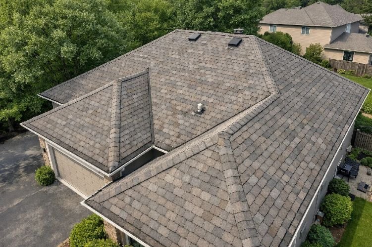
Property Roof Condition Assessment
Revolutionize property underwriting with AI-powered roof inspection and roof condition assessment using high-resolution aerial imagery. Our service analyzes roof age, material type, condition indicators, and damage with 95% accuracy, processing properties in under 2 seconds without costly physical inspections or dangerous roof access.
This technology detects roof material (asphalt, metal, tile), identifies wear patterns, missing shingles, granule loss, vegetation proximity, and undeclared property features like pools or trampolines. Essential for remote underwriting, renewal decisions, and dynamic premium adjustment, this service enables insurers to assess small-value properties economically while improving portfolio risk quality.
Key Benefits
- 95% roof age accuracy to exact year
- Processing speed under 2 seconds per property
- $47.45 CPC value for roof inspection keyword
- Eliminates dangerous physical roof inspections
- Enables remote underwriting of any property size
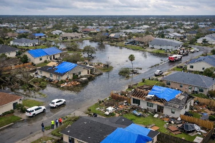
Post-Disaster Damage Assessment (CAT Response)
Accelerate catastrophe response with building-level hurricane damage assessment, storm damage assessment, and disaster impact evaluation delivered within 24 hours of event landfall. Using SAR and optical satellite imagery with AI-powered change detection, this service provides immediate loss estimates, damage heat maps, and claims triage intelligence.
Critical for hurricanes, wildfires, floods, tornadoes, and earthquakes, our CAT response service operates through clouds, smoke, and darkness using all-weather SAR technology. This capability enables insurers to mobilize emergency funds, contact affected policyholders proactively, dimension total financial exposure, and deploy adjusters to highest-impact zones before ground access is possible.
Key Benefits
- Building-level damage assessment within 24 hours
- All-weather SAR operates through clouds and smoke
- $35.77 CPC for storm damage assessment
- Reduces late-reporting claims through proactive contact
- Dimensions portfolio exposure in hours vs weeks
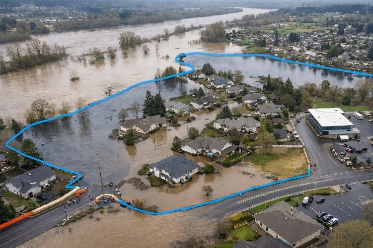
Flood Risk Mapping & Monitoring
Manage flood exposure with comprehensive flood monitoring, flood mapping, and flood risk mapping using SAR satellite technology that penetrates clouds and rain. Our service provides 24-hour early warnings, real-time extent monitoring during active floods, and building-level depth estimation for accurate loss forecasting and parametric trigger verification.
Essential for flood zone mapping, floodplain mapping, and coastal flood risk assessment, this technology addresses the reality that 90% of natural disasters are climate-related and primarily flood events. With updates every 6 hours during active flooding, insurers can identify affected policyholders, activate parametric coverages, and triage claims based on actual inundation data.
Key Benefits
- 24-hour early warning before flood events
- Real-time monitoring with 6-hour updates
- Building-level flood depth estimation
- SAR technology operates through storm clouds
- Supports parametric flood trigger verification
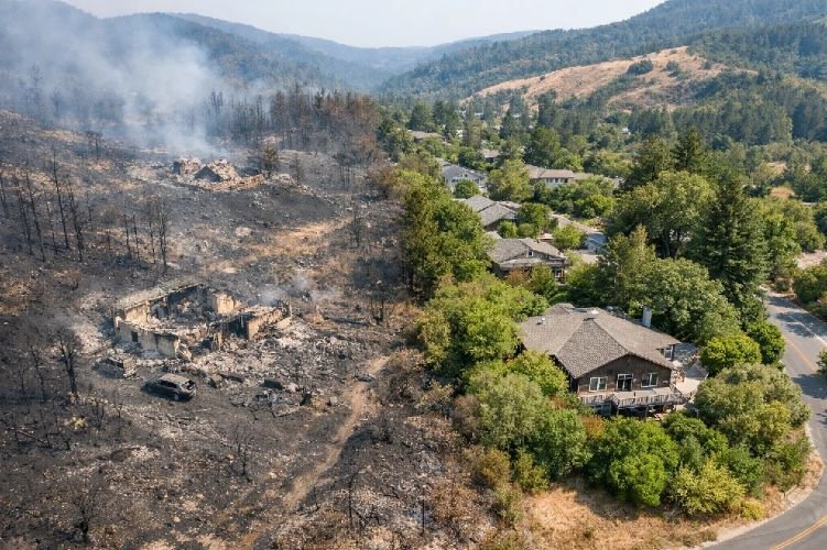
Wildfire Risk Assessment & Damage Detection
Protect portfolios from escalating wildfire losses with precise wildfire risk assessment, vegetation proximity analysis, and post-fire building-level damage detection. Following the $38 billion Los Angeles fires (2025 – costliest wildfire in US history), this service evaluates defensible space, identifies high-risk properties in wildland-urban interface zones, and tracks active fire progression.
Our technology assesses pre-fire risk factors including tree proximity, vegetation density, and fuel loads using NDVI analysis, monitors fire progression in near real-time, and provides post-fire damage assessment within 24 hours. With UN projections forecasting 14% increase in extreme fires by 2030, this service enables risk-based premium adjustment and parametric wildfire trigger verification.
Key Benefits
- Vegetation proximity and defensible space measurement
- Building-level damage detection within 24 hours
- $7.26 CPC wildfire risk assessment keyword
- 44X better accuracy than regional models
- Supports 30-40% premium increases justification
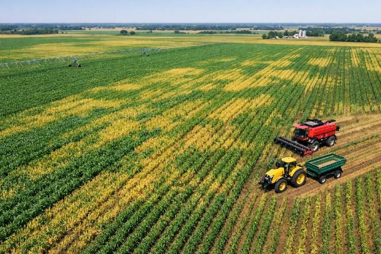
Agricultural Crop Insurance Verification
Optimize farm insurance and agricultural coverage with satellite-based crop monitoring using NDVI and multispectral analysis. This service verifies crop health, validates loss claims, and enables index based insurance and weather index insurance programs without expensive field inspections, reducing basis risk by up to 41% through precise spatial measurement.
Applied successfully in index-based insurance programs worldwide, our monitoring tracks drought stress, rainfall impacts, crop maturity, and yield estimation throughout growing seasons. With NDVI used in 77% of crop insurance studies and 91% utilizing satellite earth observation, this proven technology accelerates claims resolution by 40% while improving accuracy and farmer trust.
Key Benefits
- NDVI used in 77% of crop insurance programs
- Reduces basis risk up to 41%
- Claims resolution 40% faster without field visits
- Supports parametric agricultural triggers
- Enables economic coverage for smallholder farmers
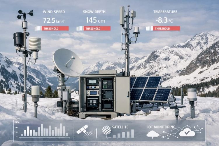
Parametric Insurance Trigger Verification
Enable transparent, rapid parametric insurance payouts with objective satellite-based trigger verification for wind speed, rainfall thresholds, flood depth, burnt area, crop health indices, temperature extremes, and other measurable parameters. This technology eliminates subjective loss adjustment, reduces fraud, and delivers claim payments in days rather than months.
Supporting the explosive parametric insurance market growth from $17.9B (2025) to projected $53B (2034) with 12.8% CAGR, our service provides independent verification of trigger events using satellite data combined with IoT sensors. This objective measurement enables coverage for previously uninsurable risks including business interruption without physical damage, crop yield protection, and municipal disaster response funding.
Key Benefits
- Market growing $17.9B to $53B by 2034 (12.8% CAGR)
- Payouts in days vs months using objective triggers
- Eliminates subjective loss adjustment fraud
- Verifies wind, flood, fire, drought, temperature triggers
- Enables coverage for non-damage business interruption
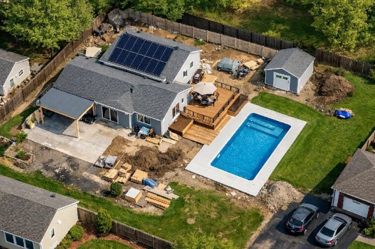
Infrastructure & Asset Change Detection
Detect undeclared property modifications and infrastructure changes with AI-powered asset verification using high-resolution optical imagery and YOLO object detection. This service identifies new pools, solar panels, additions, renovations, storage structures, and other improvements that affect property value and liability exposure but weren’t disclosed during underwriting.
Critical for maintaining accurate property intelligence and closing coverage gaps, this technology enables dynamic premium adjustment, identifies under-insured properties, validates policyholder declarations, and optimizes inspection scheduling. With major insurers targeting remote surveys for 50% of property risks, automated change detection reduces underwriting expense while improving portfolio risk quality.
Key Benefits
- Detects undeclared pools, additions, renovations
- $21.82 CPC for property intelligence keyword
- Enables dynamic premium adjustment
- Identifies under-insured properties automatically
- Reduces coverage gaps and underwriting expense
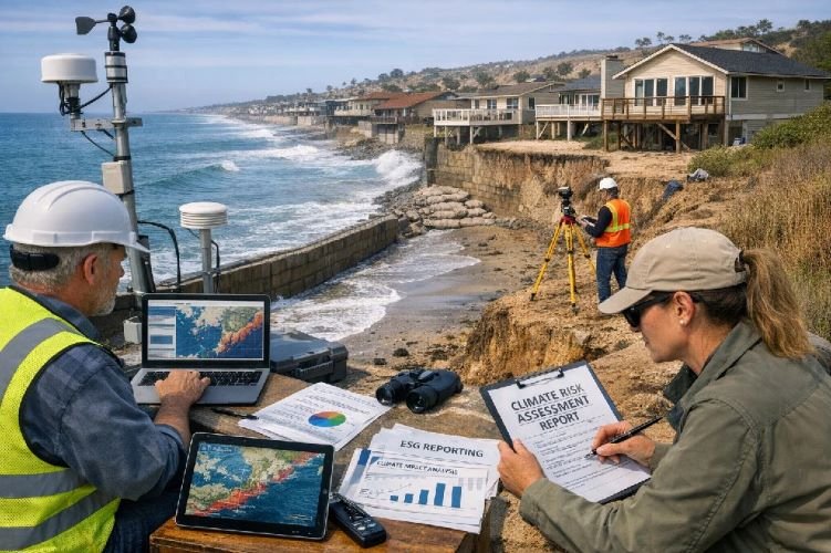
Climate Risk & ESG Reporting
Support regulatory compliance and investor transparency with comprehensive climate risk insurance assessment and ESG reporting using satellite-derived climate models. This service evaluates long-term flood exposure, wildfire vulnerability, sea-level rise impacts, and extreme weather trends across insurance portfolios, enabling forward-looking risk disclosure and climate resilience planning.
With only 42% of 2024 disaster losses insured (massive protection gap) and regulators permitting forward-looking climate models in California and other jurisdictions, this service provides portfolio-level climate vulnerability analysis. Support corporate ESG alignment, regulatory compliance, and stakeholder communication while identifying emerging risks and opportunities in climate-affected markets.
Key Benefits
- Portfolio-level climate vulnerability assessment
- Addresses $1+ trillion insurance protection gap
- Regulatory-approved forward-looking models
- Supports ESG disclosure and investor transparency
- Identifies emerging climate risks and opportunities
Why Choose Satellite-Based Insurance Technology?
Enhanced Underwriting Efficiency
Remote property assessment eliminates costly physical inspections while enabling economic underwriting of small-value risks. Process thousands of properties daily with 95% accuracy, optimize portfolio quality, and reduce acquisition costs through scalable satellite intelligence.
Rapid Catastrophe Response
Building-level damage assessment within 24 hours of disaster enables immediate loss estimation, proactive policyholder contact, and optimized adjuster deployment. SAR technology operates through clouds and smoke when traditional methods fail, reducing claim cycle time by weeks.
Data-Driven Risk Management
Objective satellite data reduces fraud, validates parametric triggers, and supports predictive analytics for proactive risk management. Independent verification builds policyholder trust while enabling innovative products like parametric coverage and index-based insurance.
Ready to Transform Your Insurance Operations?
Join leading insurers worldwide using satellite technology for property risk assessment, catastrophe response, and predictive analytics to reduce loss ratios, accelerate claims, and improve customer experience.
Contact Us Today