Aeromagnetic Survey: How Airborne Geophysics Finds Mineral Deposits Before You Drill
Every exploration geologist knows the feeling: months of planning, hundreds of thousands of dollars in drilling costs, and the core samples come back empty. The dreaded «dry hole» is not just a disappointment—it is a financial blow that can derail entire projects. With exploration drilling costs ranging from $100 to over $300 per meter, a single unsuccessful borehole can easily consume $100,000 or more. Multiply that by the typical number of holes needed to define a deposit, and the stakes become clear.
The question that keeps exploration managers awake at night is simple: How do I know where to drill?
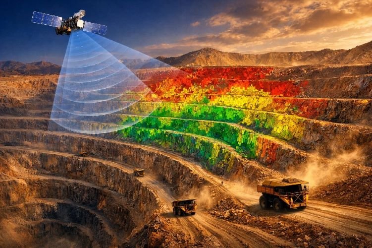
This is where the aeromagnetic survey enters the picture. By measuring variations in the Earth’s magnetic field from an aircraft, this technique reveals what lies beneath the surface—structures, faults, and mineral concentrations—without breaking ground. At a fraction of the cost of drilling, airborne geophysics provides the intelligence needed to focus exploration efforts where they matter most.
At SkyIntelGroup, we deliver airborne geophysical survey services that transform raw magnetic data into actionable exploration targets. Our approach combines proven technology with expert interpretation, helping mining companies reduce risk and maximize the return on their exploration investment.
What Is an Aeromagnetic Survey and Why Mining Companies Need It
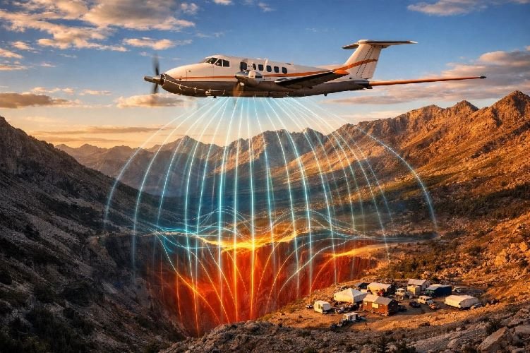
An aeromagnetic survey is a geophysical technique that measures the intensity of the Earth’s magnetic field using instruments mounted on aircraft. As the plane flies in a systematic grid pattern, onboard magnetometers record subtle variations caused by the magnetic properties of rocks below the surface. These variations, called magnetic anomalies, provide a window into the subsurface geology that would otherwise remain invisible.
The Science Behind Magnetic Detection
The principle is straightforward. Different rock types contain varying amounts of magnetic minerals, primarily magnetite and pyrrhotite. When an aircraft equipped with a magnetometer passes over these rocks, the sensor detects the combined magnetic signal from the Earth’s core field plus the local contribution from subsurface materials.
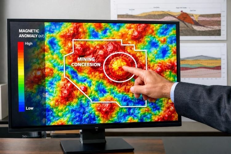
By processing thousands of measurements and removing background noise from solar activity and the aircraft itself, geophysicists create detailed maps showing the spatial distribution of magnetic minerals. These maps reveal geological structures such as faults, fold axes, intrusive bodies, and contacts between different rock units—all critical information for mineral exploration.
The beauty of this method lies in its ability to see through surface cover. Sand, soil, vegetation, and even shallow water that obscure bedrock from direct observation pose no obstacle to magnetic detection. This makes aeromagnetic surveys particularly valuable in regions where traditional geological mapping is difficult or impossible.
When Aeromagnetic Surveys Save Millions
Consider the economics. A typical aeromagnetic survey costs between $11 and $18 per line-kilometer for data acquisition and processing combined. For a 1,000 km² reconnaissance survey with 500-meter line spacing, the total investment might range from $25,000 to $50,000. Compare this to drilling, where a single 300-meter exploration hole in Mexico costs approximately $272 per meter—over $80,000 for one hole that may or may not intersect mineralization.
The math is compelling. Before committing to expensive drilling programs, companies can use geophysical mapping to systematically evaluate large areas and identify the most promising targets. Industry data suggests that satellite and geophysical prospectivity mapping can reduce the area requiring detailed exploration by 70 to 90 percent, focusing drilling budgets on high-probability zones rather than speculative locations.
High-altitude mountainous terrain, dense jungle, or remote desert—environments that present significant challenges for ground-based exploration—are no obstacle for airborne surveys. A magnetic survey aircraft can cover terrain in days that would take ground crews months to traverse, eliminating logistical nightmares and safety risks while delivering comprehensive subsurface data.
How SkyIntelGroup Delivers Aeromagnetic Survey Services
At SkyIntelGroup, we understand that raw data alone does not find mineral deposits—interpretation does. Our airborne geophysical survey services are designed to deliver not just measurements, but actionable intelligence that guides your exploration decisions.
Our Process: From Flight Planning to Actionable Maps
Every project begins with understanding your objectives. Whether you are conducting regional reconnaissance over a new concession or detailed surveys over known prospects, we tailor the survey parameters—line spacing, flight altitude, sensor configuration—to match your exploration goals and budget.
Flight execution follows rigorous protocols. Our survey aircraft fly precise grid patterns using GPS navigation, maintaining consistent altitude and heading to ensure data quality. Magnetometers record continuously, capturing the subtle variations that reveal subsurface structure.
Data processing transforms millions of raw readings into coherent images. We apply corrections for diurnal variations, remove aircraft interference, and grid the data to produce maps showing total magnetic intensity and its derivatives. Advanced filtering techniques enhance features at different depths, allowing interpretation of both shallow and deep sources.
Interpretation is where SkyIntelGroup adds the most value. Our geophysicists analyze the processed data in the context of regional geology, identifying structural trends, lithological contacts, and magnetic anomaly detection targets that warrant follow-up. The final deliverable includes prioritized recommendations for ground truthing and drilling, not just pretty maps.
What Sets Us Apart
Many providers stop at data delivery. We go further by integrating magnetometer survey results with other geospatial datasets—satellite imagery, topographic models, and available geological information—to build a comprehensive picture of your exploration area.
Our interpretation workflows incorporate pattern recognition techniques that identify subtle signatures often missed by conventional analysis. By combining magnetic data with multispectral satellite analysis, we can correlate surface alteration patterns with subsurface anomalies, increasing confidence in target prioritization.
We also provide clear communication. Technical jargon has its place, but exploration managers need to understand what the data means for their drilling programs. Our reports explain findings in practical terms: where to drill, why these locations were selected, and what level of confidence supports each recommendation.
Ready to Reduce Your Exploration Risk?
Let SkyIntelGroup show you what lies beneath your concession before you invest in drilling. Our aeromagnetic survey services deliver the geological intelligence you need to make confident decisions.
Contact Our Geophysics Team →Traditional Drilling vs. Geophysics-First Approach
The conventional exploration model—acquire a concession, define some targets based on surface geology or historical data, then start drilling—carries substantial risk. Without subsurface information, drilling locations are often selected based on incomplete evidence, leading to expensive failures.
The geophysics-first approach inverts this sequence. By conducting an aeromagnetic survey before committing to drilling, exploration teams gain critical information about geological structure, ore body detection potential, and target prioritization. The drilling program that follows is surgical rather than exploratory, focused on validating specific anomalies rather than searching blindly.
The Numbers Don’t Lie
The economics of exploration are unforgiving. Most exploration drilling campaigns do not result in economic discoveries. The industry average success rate for greenfield exploration is notoriously low, with the vast majority of drilled targets failing to deliver mineable resources.
By investing in airborne geophysical survey data before drilling, companies fundamentally change these odds. Geophysical targeting does not guarantee success, but it eliminates the weakest targets from consideration and concentrates drilling on locations with the strongest geological evidence. Reports from companies using satellite-based prospectivity mapping indicate exploration cost savings of 80 to 85 percent compared to traditional methods—savings achieved primarily by avoiding wasted drilling.
The calculation is simple: a $30,000 aeromagnetic survey that prevents three or four unsuccessful drill holes has already paid for itself many times over. The real value comes from finding the deposit faster by drilling the right targets first.
Modern Aeromagnetic Technology: Aircraft, Drones, and AI
The technology behind aeromagnetic surveys has evolved dramatically. While the fundamental physics remain unchanged, advances in sensors, platforms, and data processing have transformed what is possible.
Fixed-Wing vs. Helicopter vs. Drone Surveys
The choice of survey platform depends on project requirements. Each option offers distinct advantages:
Fixed-wing aircraft remain the workhorses of regional exploration. They cover large areas efficiently, flying at consistent speeds and altitudes to acquire systematic data. For reconnaissance surveys over thousands of square kilometers, fixed-wing platforms offer the best cost-per-kilometer ratio. Typical applications include regional geological mapping and early-stage exploration over new concessions.
Helicopters provide greater flexibility in mountainous or complex terrain. They can fly lower and slower than fixed-wing aircraft, achieving higher spatial resolution. When detailed surveys over specific prospects are required, or when terrain prevents safe fixed-wing operations, helicopters become the platform of choice. The trade-off is higher operating cost per line-kilometer.
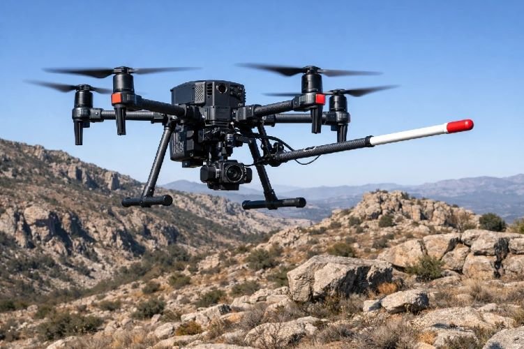
UAV magnetic surveys represent the newest frontier. Drones equipped with magnetometers offer ultra-high resolution at lower operational cost than manned aircraft for small areas. They require fewer crew members, eliminate pilot risk, and can access terrain that would be dangerous for conventional aircraft. The technology is maturing rapidly, with cesium-vapor and fluxgate magnetometers now miniaturized for drone deployment. For detailed infill surveys or target-scale investigations, UAV magnetic survey systems are increasingly competitive.
How AI Is Transforming Data Interpretation
The volume of data generated by modern geophysical surveys exceeds what human analysts can efficiently process using traditional methods. Machine learning algorithms are now standard tools for extracting meaning from these datasets.
Pattern recognition models trained on known deposits can identify similar signatures in new survey data, flagging subtle anomalies that might escape visual inspection. Deep learning architectures analyze magnetic data alongside other inputs—gravity, electromagnetic, satellite imagery—to generate integrated prospectivity assessments. Detection accuracy improvements of up to 92 percent have been reported when AI-enhanced interpretation is applied to mineral exploration datasets.
At SkyIntelGroup, we leverage these advances to deliver interpretations that go beyond conventional analysis. Our workflows combine automated anomaly detection with expert geological oversight, ensuring that machine-identified targets are validated against structural and lithological context before inclusion in exploration recommendations.
Real-World Applications: Where Aeromagnetic Surveys Deliver Results
The versatility of aeromagnetic survey techniques makes them applicable across a wide range of exploration scenarios. From precious metals to industrial minerals, magnetic data provides insights that guide efficient exploration.
Gold, Copper, and Iron Ore Exploration
Many economically important deposits are associated with distinctive magnetic signatures. Iron ore deposits, being composed largely of magnetite, produce obvious high-amplitude anomalies that are easily detected and mapped. These surveys have been fundamental to iron ore exploration for decades.
Gold and copper deposits often occur in association with intrusive igneous rocks that have measurable magnetic properties. More importantly, the structural settings that control mineralization—faults, shear zones, contacts between rock units—are frequently expressed in magnetic data. By mapping these structures, geophysicists delineate favorable exploration corridors even when the ore minerals themselves are not magnetic.
Hydrothermal alteration associated with porphyry copper and epithermal gold systems can destroy magnetic minerals, creating low-magnetic zones surrounded by higher-intensity background. This «demagnetization» effect provides an indirect but powerful exploration vector. Combined with satellite-derived alteration mapping, magnetic surveys help pinpoint the centers of mineralizing systems.
Mapping Geological Structures in Remote Areas
Beyond direct mineral detection, aeromagnetic data serves as a geological mapping tool of unparalleled efficiency. In regions where bedrock is concealed beneath transported cover—alluvium, glacial deposits, laterite—magnetic surveys reveal the underlying structure that surface mapping cannot access.
Fault systems that control fluid flow and mineral deposition become visible in processed magnetic images. Buried intrusive complexes that may host mineralization are detected beneath barren cover sequences. Contacts between prospective and non-prospective rock units are delineated, focusing exploration on favorable lithologies.
For exploration teams operating in remote or frontier regions, this structural intelligence is invaluable. It enables rational target selection based on geological principles rather than guesswork, ensuring that limited exploration budgets are deployed where they have the highest probability of success.
Explore Smarter, Not Harder
From flight planning to prioritized drill targets, SkyIntelGroup delivers complete aeromagnetic survey solutions. Let us help you see what is beneath your concession.
Request a Project Consultation →Frequently Asked Questions About Aeromagnetic Surveys
How much does an aeromagnetic survey cost?
Costs depend on survey size, line spacing, terrain complexity, and location. For regional reconnaissance with 500-meter line spacing, expect $11 to $18 per line-kilometer including acquisition, processing, and basic interpretation. A 1,000 km² survey might cost $25,000 to $50,000. Detailed surveys with tighter line spacing over smaller areas cost more per kilometer but less in total. Compared to drilling at $100 to $300 per meter, geophysical surveys represent a fraction of exploration budgets while providing area-wide coverage that drilling cannot match.
How long does an aeromagnetic survey take?
Survey duration depends on area size and weather conditions. A typical 500 km² project might require 3 to 5 days of flying under good conditions, plus 2 to 4 weeks for data processing and interpretation. Total project timelines from mobilization to final report delivery typically range from 4 to 8 weeks. Compare this to drilling programs that require months for permitting, equipment mobilization, and execution.
Can aeromagnetic surveys detect all types of minerals?
No single technique detects all minerals. Aeromagnetic surveys excel at detecting magnetite, pyrrhotite, and other magnetic minerals, making them ideal for iron ore exploration and for mapping structures associated with various deposit types. Non-magnetic minerals like gold, copper, zinc, and lithium are not directly detected. However, these deposits often occur in geological settings with associated magnetic signatures—alteration halos, structural controls, intrusive hosts—that magnetic surveys can identify. SkyIntelGroup typically recommends integrating magnetic data with gravity, electromagnetic, and satellite remote sensing to build a complete exploration picture.
How does aeromagnetic data integrate with other exploration methods?
Magnetic surveys provide one layer of subsurface information that becomes more powerful when combined with complementary techniques. Gravity surveys measure density variations, detecting dense sulfide bodies or low-density alteration zones that magnetic surveys might miss. Electromagnetic surveys directly detect conductive mineralization. Satellite multispectral data reveals surface alteration associated with buried deposits. At SkyIntelGroup, we integrate these datasets to create comprehensive prospectivity assessments that leverage the strengths of each method while compensating for individual limitations.