Open Pit Slope Failure: What the Data Shows Before the Ground Moves — and What Most Mines Are Missing
On February 13, 2024, the heap leach pad at the Çöpler Gold Mine in eastern Turkey collapsed. Ten million cubic meters of material mobilized in seconds, traveling nearly a kilometer through the valley below. Nine miners were buried. Operations at one of Turkey’s largest gold producers — responsible for 20% of the country’s total gold output — came to an immediate halt.
What makes Çöpler the defining case study of our era is not the scale of the disaster. It is what researchers found when they analyzed the satellite radar data afterward. The slope had been moving continuously for at least four years before the collapse, at rates of up to 60 millimeters per year — well within the detection capability of InSAR satellite monitoring. The signal was there. Nobody was reading it.
That pattern — deformation preceding failure, monitoring that does not cover the right area, a collapse that arrives as a surprise when it should not have — is not unique to Çöpler. It is the common thread running through every major open pit slope failure of the past decade. This article is not about the technology that detects slope movement. It is about what happens before the ground moves, what it costs when it does, and why most open pit mines are still not capturing the signals that could change the outcome. SkyIntelGroup works with mining operators worldwide to close that gap before it becomes a catastrophe.
What an Open Pit Slope Failure Actually Costs
The conversation about slope instability in mining is often framed in safety terms — and rightly so. But for the VP of Operations reviewing a monitoring budget, the financial argument is equally compelling, and it is one that recent events have made impossible to ignore.
At Grasberg in Indonesia — the world’s second-largest copper mine — a ground failure event in September 2025 triggered a full operational shutdown. Freeport-McMoRan declared force majeure and announced that copper and gold output at the site could be approximately 35% lower in 2026 than previously estimated. The original production forecast had been 1.7 billion pounds of copper and 1.6 million ounces of gold. The immediate market reaction was dramatic: copper prices surged to 15-month highs of $10,485 per metric ton in the week following the announcement — a reminder that a single geotechnical event at a major mine does not stay within the fence line. It moves global commodity markets.
At Xinjing in China, the February 2023 open pit coal mine landslide resulted in 53 fatalities and documented economic losses of $28.7 million — and that figure covers only direct costs, not the extended production disruption, regulatory investigation, legal exposure, or reputational damage that follow any fatality event.
The costs that rarely make it into the headline figure are the ones that accumulate after the failure: removal of failed material from the pit floor, reforming of benches, rerouting of haul roads, repair of damaged infrastructure, third-party investigations, regulatory compliance proceedings, and in the case of fatalities, litigation that can extend for years. For a mid-size copper or gold operation, a production shutdown of several months can represent losses that dwarf the entire annual budget for geotechnical monitoring by an order of magnitude.
The economic case for geotechnical monitoring in open pit mines does not require a complex analysis. The cost of not monitoring is the cost of the next event.
The Warning Signs That Were There All Along
The Çöpler case deserves more attention than it has received in the operational mining community, because it demonstrates something that changes the nature of the geotechnical risk conversation entirely.
Post-event analysis by researchers at the GFZ German Research Centre for Geosciences, published in The Seismic Record in 2025, confirmed that InSAR satellite data showed continuous, measurable deformation at the Çöpler site for at least four years before the February 2024 failure. The average line-of-sight velocity across the affected area was up to 60 millimeters per year. At the heap leach pad embankment specifically — the structure that ultimately failed — deformation rates of 85 millimeters per year were detectable in the data prior to collapse. These are not subtle signals. They are unambiguous indicators of ongoing slope movement at rates that any competent geotechnical review would flag as requiring intervention.
The failure was not unforeseeable. It was unmonitored.
This pattern is consistent across the documented record of open pit wall failures worldwide. Slope collapses in open pit mines do not typically occur instantaneously from a static state. They follow a progression: initial slow creep, often detectable for months or years; a period of accelerating deformation as the failure surface develops; and finally, rapid collapse when the driving forces exceed the remaining resistance. The window between detectable acceleration and final failure — the window in which evacuation, haul road rerouting, and slope remediation are still possible — can be weeks or months wide. Whether that window is used depends entirely on whether someone is measuring.
Why Conventional Monitoring Leaves Gaps That Satellite Data Fills
No monitoring technology in use today is without limitations. Understanding what each system can and cannot see is the starting point for designing a monitoring program that actually covers the full risk area of an open pit mine.
Prism networks and total stations provide high-precision displacement measurements at specific points, but their coverage is defined entirely by where sensors have been installed. An instability that develops outside the prism network — in an area considered low-priority at the time of installation, or in a zone that was inaccessible when the network was designed — will not appear in the data until it has already progressed significantly.
Ground-based radar (GBR) systems are the most effective tool currently available for real-time monitoring of active pit walls. They detect movement continuously, operate through most weather conditions, and provide the fast alert capability needed to protect workers in high-hazard zones. Their limitation is geometric: they have a defined field of view, and what lies outside that field of view — behind the pit crest, on the natural slope above the mine boundary, on inactive walls — is invisible to them. A documented case study in the technical literature describes a 2016 open pit mine failure in which ground-based radar was performing correctly within its coverage zone. What it could not see was that the developing instability extended far beyond the pit crest into natural slope terrain. Satellite deformation data acquired retrospectively showed accelerating movement in that hidden zone for nine months before the final collapse. The scale of the failure far exceeded what the ground-based monitoring had suggested was possible.
Drone photogrammetry generates excellent visual documentation of slope condition and can detect surface cracking and bench degradation. It does not measure sub-millimeter deformation over time, and its utility depends on regular flight campaigns and favorable weather.
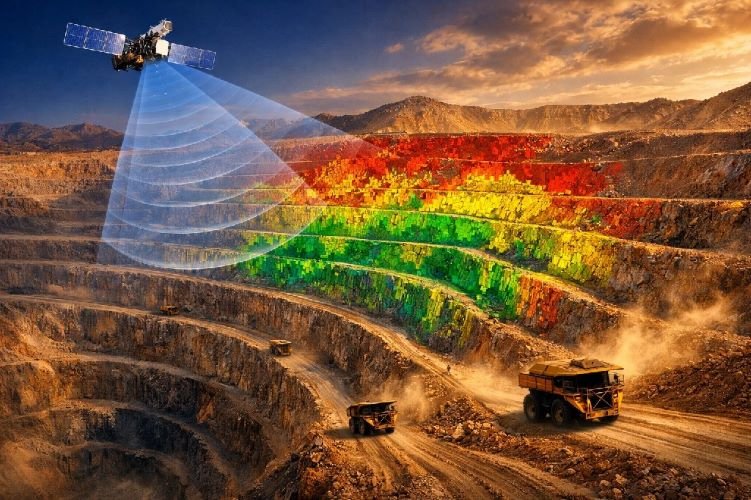
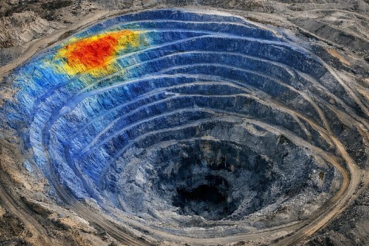
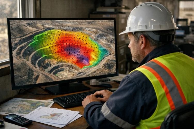
Satellite InSAR addresses the coverage limitation directly. A single satellite pass produces a deformation map of the entire mine footprint — active pit walls, inactive walls, waste dumps, heap leach pads, haul roads, tailings facilities, and surface infrastructure — without requiring installation of a single sensor on potentially unstable ground. Measurement precision is in the millimeter range per year. Coverage is complete regardless of where the instability is developing.
The operational conclusion is not that satellite monitoring replaces ground-based radar. It is that satellite monitoring covers what ground-based radar cannot see. For the mines that are currently running GBR on their active walls and nothing else on the remaining 80% of their site, the question is not whether they have good monitoring — it is whether they have complete monitoring. The technical details of how InSAR works in mining applications, including processing methods and detection thresholds, are covered in our guide to slope stability monitoring.
| Method | Coverage | Requires Field Installation | Early Detection | Beyond Pit Crest |
|---|---|---|---|---|
| Prism Network | Points only | Yes — in risk zone | Limited to installed points | No |
| Ground-Based Radar | Active wall only | Yes — at pit edge | Excellent in field of view | No |
| Drone Photogrammetry | Visual surface only | No | Surface cracking visible | Partial |
| Satellite InSAR | Entire mine footprint | No | mm-scale, months in advance | Yes — full coverage |
The Regulatory Reality: What Authorities Now Expect After Çöpler and Grasberg
The geotechnical events of 2023, 2024, and 2025 have accelerated a shift that was already underway in major mining jurisdictions: regulators are moving from prescriptive monitoring requirements toward performance-based frameworks that demand demonstrable early warning capability, not just the presence of instrumentation.
In Australia, the Department of Mines, Industry Regulation and Safety (DMIRS) requires that open pit operations maintain a geotechnical management plan that includes active slope monitoring — and critically, that the monitoring system provides coverage adequate to detect instability before it becomes critical. Post-incident investigations increasingly examine whether the monitoring in place was fit for purpose, not merely whether monitoring existed.
In Canada, the Mining Association of Canada’s geotechnical practice guidelines, updated in the post-Brumadinho period, explicitly acknowledge satellite InSAR as a recognized monitoring method for both open pit walls and tailings facilities — a recognition that carries weight in regulatory compliance discussions.
In Chile, SERNAGEOMIN’s geotechnical stability regulations require documented monitoring programs with defined alert thresholds and response protocols. The Codelco El Teniente collapse of July 2025 — which killed six workers and forced a complete shutdown of one of the world’s largest copper operations — has already prompted additional scrutiny of monitoring programs across Chilean operations.
The regulatory dynamic that matters most for any mine operator reviewing their monitoring program is this: after a pit wall failure, investigators examine what the monitoring system was capable of detecting and whether it was deployed where the risk was. A system that covers the active wall but nothing else does not demonstrate that the operator took a comprehensive approach to slope failure prevention. The mine that can show satellite deformation data covering its entire footprint, with a documented history of alert thresholds and responses, is in a fundamentally different position — legally, regulatorily, and with its insurer — than the mine that cannot.
How SkyIntelGroup Monitors Open Pit Walls Before They Move
The operational question for a geotechnical team looking at satellite mine slope monitoring is not whether it works — the Çöpler retrospective analysis makes that clear — it is how to integrate it into an existing monitoring program without disrupting operations or requiring extensive new infrastructure.
SkyIntelGroup delivers satellite-based deformation monitoring for open pit mines across the full site footprint, including active and inactive pit walls, waste rock dumps, heap leach pads, tailings facilities, haul roads, and surface infrastructure. The process requires no sensor installation in the field — no access to unstable ground, no calibration campaigns, no maintenance. Analysis uses SAR satellite imagery processed through interferometric methods to detect and quantify surface displacement at millimeter-scale precision, mapped across the entire mine area in a single analysis.
One of the most operationally useful aspects of satellite monitoring is the availability of historical archive data. Satellite SAR imagery archives extend back several years for most mine sites globally, which means that a baseline deformation analysis delivered at the start of a monitoring contract includes the displacement history of the site — not just its current state. For operations that have never had InSAR monitoring, this historical baseline is the equivalent of having had monitoring running for years before the contract started. It is how the Çöpler signals could be reconstructed retroactively — and it is exactly the kind of data that geotechnical engineers need to understand whether a slope has been stable or has been creeping since before the current monitoring program began.
Output is structured for operational use: velocity maps showing displacement rates across the pit footprint, time-series graphs for zones of interest, and alert thresholds agreed with the client’s geotechnical team that trigger notification when deformation rates exceed defined parameters. The satellite data does not replace the geotechnical engineer’s judgment — it gives that judgment more to work with, covering the zones that existing systems cannot reach.
SkyIntelGroup’s full range of satellite intelligence services for mining operations — including tailings dam monitoring, subsidence analysis, and environmental compliance — is available on the Mining services page.
Frequently Asked Questions About Open Pit Slope Failure
How far in advance can satellite InSAR detect open pit slope movement before failure?
The detection window depends on the rate of deformation and the failure mechanism, but the documented evidence from real events is significant. At Çöpler, satellite data showed measurable movement for at least four years before the 2024 collapse. Technical literature on open pit slope failures consistently documents precursory deformation periods ranging from weeks to months before rapid collapse, with the acceleration phase — the most critical window for intervention — typically detectable several weeks in advance. The key variable is not the technology’s detection capability, which is well established at millimeter-scale precision per year, but whether satellite monitoring was deployed and being actively reviewed when the acceleration began.
Can satellite monitoring replace ground-based radar in an active open pit mine?
No — and that is not its purpose. Ground-based radar systems provide the real-time, high-frequency alert capability needed to protect workers in active mining zones where movement can accelerate rapidly. Satellite InSAR operates on acquisition cycles of days to weeks and is not designed for real-time operational alerts in active high-hazard zones. What satellite monitoring provides is wide-area coverage of the entire mine footprint — including the zones beyond the radar’s field of view — and long-term deformation trend analysis that places the active-wall data in a broader geotechnical context. The most effective monitoring programs combine both: ground-based radar for the active face, satellite InSAR for everything else.
What was the Çöpler mine failure and what did satellite data show beforehand?
The Çöpler Gold Mine in eastern Turkey experienced a catastrophic flowslide on February 13, 2024, when its heap leach pad failed. Approximately 10 million cubic meters of material mobilized rapidly, resulting in nine confirmed fatalities. Post-event analysis published in The Seismic Record in 2025 by researchers at the GFZ German Research Centre for Geosciences confirmed that InSAR satellite data showed continuous deformation at the site at rates of up to 60 millimeters per year over the four years preceding the collapse. The heap leach pad embankment showed rates of 85 millimeters per year prior to failure. The study also identified deformation anomalies in other sectors of the mining operation that could potentially lead to similar events — a finding that underscores the value of full-site satellite coverage rather than monitoring only the most obviously active areas.
Which mining jurisdictions require geotechnical monitoring systems for open pit operations?
Australia, Canada, Chile, South Africa, and most major mining jurisdictions require documented geotechnical management plans that include active monitoring for open pit operations. The specific requirements vary — Australia’s DMIRS framework, Canada’s MAC guidelines, Chile’s SERNAGEOMIN regulations — but the common direction across jurisdictions is toward performance-based requirements that demand demonstrable early warning capability. Post-incident investigations in multiple jurisdictions have examined not just whether monitoring existed, but whether it was deployed in a way that could reasonably have detected the developing instability. Operations that can demonstrate comprehensive, full-site deformation monitoring are in a stronger compliance position than those with systems covering only portions of the mine.
How does SkyIntelGroup’s slope monitoring work for mines in remote locations?
Satellite monitoring has no installation requirements at the mine site, which makes remote location irrelevant to the delivery of the service. Analysis is performed on satellite imagery acquired from orbit — the mine’s geographic remoteness, road access, and local infrastructure have no bearing on the ability to monitor it. For mine sites in areas with limited historical monitoring, the satellite archive typically provides several years of retrospective deformation data that can be analyzed immediately, giving operations in any location access to a historical baseline that would otherwise require years of active monitoring to accumulate.
What is the cost of satellite-based slope monitoring compared to a production shutdown?
The comparison is not close. A mid-size open pit copper or gold operation running at full capacity generates revenue that makes even a short production shutdown — measured in days, not months — more expensive than a multi-year satellite monitoring program. The Grasberg event resulted in production losses extending through all of 2026 at a 35% deficit from forecast. The Xinjing event generated $28.7 million in direct economic losses from a single day’s collapse, not counting extended disruption, regulatory costs, and legal exposure. Satellite monitoring for a typical open pit operation is a recurring service cost that is justifiable purely on the basis of the insurance it provides against partial or total production loss — before adding the safety benefits, regulatory compliance value, and legal protection that comprehensive deformation monitoring provides.
Conclusions
The evidence from Çöpler, Grasberg, Xinjing, and the broader record of open pit wall failures over the past decade points to the same conclusion: slope collapses in open pit mines are rarely geological surprises. They are monitoring failures. The deformation that precedes them is measurable, the signals are legible, and the window for intervention — evacuation, remediation, slope management — is often measured in weeks or months, not hours.
The monitoring programs that missed these signals were not negligent by design. They were designed around the tools available when they were built — ground-based radar pointing at the active face, prism networks on the slopes considered highest-risk at the time of installation. What they did not cover was the rest of the site. And in mining, what you do not measure is where the next event is most likely to occur.
The mine operator who deploys satellite slope deformation monitoring before an event arrives with data, with a documented response history, and with the ability to demonstrate to a regulator, an insurer, and a court that the monitoring program was comprehensive and fit for purpose. The operator who deploys it after an event is building the case for why it should not happen again. Both are valid — but only one of them prevents the first event.