Methane Emissions from Oil and Gas Operations: What Satellite Data Reveals — and What Operators Must Do Now
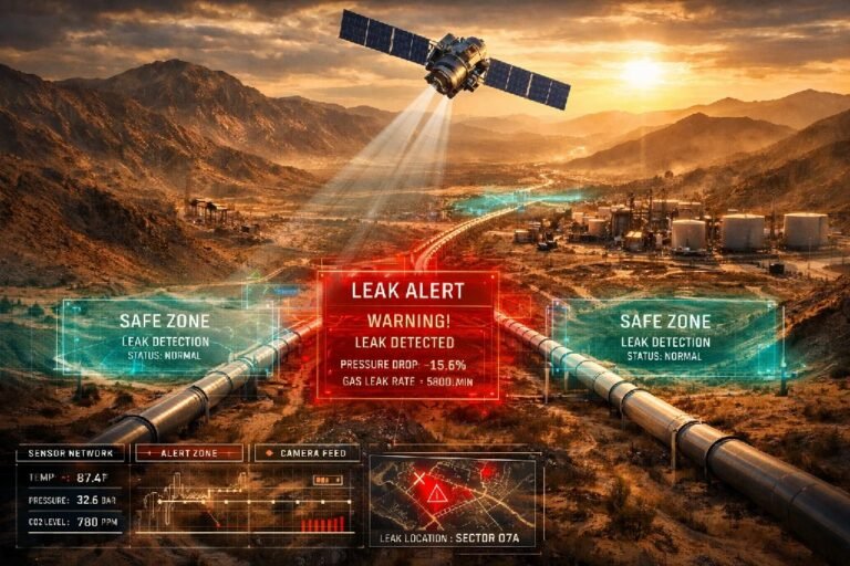
In February 2026, data collected by the MethaneSAT satellite revealed something that the oil and gas industry had long suspected but never been forced to confront publicly: methane emissions from production facilities in the Permian Basin were running at approximately four times the level reported to the U.S. Environmental Protection Agency. Within weeks, Senator Sheldon Whitehouse had launched a formal congressional investigation, demanding answers from eight of the largest operators in the basin — ExxonMobil, ConocoPhillips, Chevron, Occidental Petroleum, EOG Resources, Diamondback Energy, Devon Energy, and Mewbourne Oil — about how they measure their emissions and what they are doing to reduce them. That is not an isolated event affecting a handful of major corporations. It is a signal about the direction of an entire regulatory environment.
The methane emissions problem in oil and gas operations is not new. What is new is the ability to verify it independently from space. What was once an internal estimate, calculated using standardized emission factors that no regulator could independently check, is now a publicly observable dataset. The satellites are already overhead. The question for every operator — regardless of size, location, or current reporting method — is whether they want to be the ones measuring first, or the ones responding after someone else has already published the data.
This article is not about future technology or hypothetical regulation. It is about what is happening in 2026, what the data shows, and what operators need to do before the next deadline passes. SkyIntelGroup works with oil and gas operators across the United States, Canada, the Middle East, and North Africa to deliver independent satellite-based methane emissions monitoring that produces verifiable data — before regulators or third parties produce it for you.
The Gap Between Reported and Actual Methane Emissions Is No Longer Theoretical
For years, the discrepancy between officially reported methane emissions and independently measured emissions existed primarily in academic literature. Peer-reviewed studies using atmospheric inversion methods consistently found that national inventories underestimated fugitive methane emissions from oil and gas operations — sometimes by 50%, sometimes by more. The industry could reasonably argue that measurement methods differed and that estimates carried uncertainty in both directions.
That argument is harder to sustain in 2026.
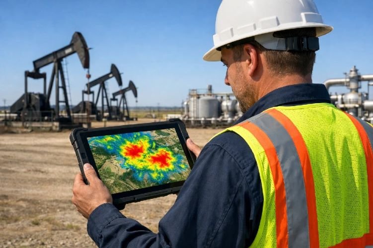
Data collected by MethaneSAT across the Permian Basin between May 2024 and June 2025 — nine separate observations covering the Delaware Sub-Basin spanning the Texas and New Mexico border — showed cumulative methane emissions from oil and gas operations of approximately 440 metric tons per hour across the region. The EPA’s official Greenhouse Gas Inventory for the same area reported approximately 104 metric tons per hour. The gap is not a rounding error. It represents more than $577 million in wasted natural gas annually from a single basin.
The geographic detail within the Permian data is equally significant for operators. New Mexico producers, operating under stricter state regulations introduced in 2021, showed a methane leakage rate of approximately 1.2% of marketed gas production. Texas producers in the same sub-basin, with the same geological characteristics and similarly young well populations, showed a rate of 3.1%. The difference is not geology. It is operational practice and regulatory pressure — which means it is correctable.
The Permian is not an outlier. A peer-reviewed study published in PNAS found that U.S. oil and gas methane emissions reporting to the EPA underestimated actual emissions by approximately 70% between 2010 and 2019, with the largest discrepancies concentrated in the Permian Basin in Texas and New Mexico, as well as the Anadarko Basin in Oklahoma and producing regions in Alberta and Saskatchewan in Canada.
Why Satellites Changed Everything for Oil and Gas Operators
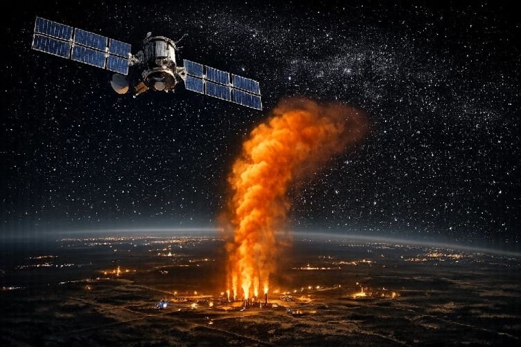
The shift from estimated to observed methane emissions monitoring is not gradual. The satellite infrastructure already deployed makes independent, facility-level methane observation a permanent feature of the operating environment — not a future possibility.
The European Space Agency’s Sentinel-5P satellite, carrying the TROPOMI instrument, covers the entire Earth’s surface daily at approximately 7km × 7km resolution, detecting methane concentration anomalies at the basin and regional level. GHGSat operates 15 dedicated greenhouse gas satellites with the ability to target specific facilities at much finer resolution, conducting approximately 13,000 daily facility-level observations in 2023 across oil, gas, and coal operations worldwide. Carbon Mapper’s Tanager-1, backed by Planet Labs and launched in 2024, detects and quantifies individual methane plumes at the well pad level. The United Nations Environment Programme’s Methane Alert and Response System (MARS) aggregates data from multiple satellite instruments and issues automatic notifications to regulators when super-emitting events are detected — without requiring the operator’s participation or consent.
The practical consequence is straightforward: oil and gas methane monitoring from space is now continuous, independent, and publicly attributable. An operator that discovers a significant emission event internally can address it quietly. An operator that is identified first by a satellite system operated by UNEP, the EPA, or a third-party analytics firm is responding to a public notification rather than managing a proactive disclosure.
The technical capabilities behind these detection systems — including hyperspectral SWIR sensing, super-emitter thresholds, and how satellite data integrates with LDAR programs — are covered in detail in our methane detection technology guide.
Where Methane Emissions from Oil and Gas Operations Are Highest — and Why It Matters for Your Business
The geographic distribution of oil and gas methane emissions determines not just which operators face the most immediate regulatory pressure, but which buyer personas are closest to a compliance crisis. The data is specific enough to be actionable.
Permian Basin, United States (Texas / New Mexico) The largest oil-producing region in the United States and, by satellite measurement, the highest-emitting oil and gas basin in the country. Emissions consistently exceed twice the national average for methane leakage rates. The congressional investigation launched in March 2026 targeting eight major operators signals that this is no longer a matter of academic debate — it is an active regulatory and reputational risk for any operator in the basin.
Alberta and British Columbia, Canada Canada updated its oil and gas methane emissions reporting methodology in 2024, which resulted in reported fugitive emissions from oil and gas increasing by more than 35% — not because emissions grew, but because the previous method had been undercounting them. Canadian LNG producers exporting to Europe face the same EU MRV deadline in January 2027 as U.S. exporters. The gap between estimated and measured emissions in Alberta’s oil sands and Montney formation has been documented in peer-reviewed literature as significant.
Middle East and North Africa (Algeria, Iraq, Iran) IEA satellite data recorded more than 800 methane emission observations over Algeria in 2024, more than 400 over Iran, and 165 over Iraq. Algeria and Iraq together represent more than 30% of global gas flaring volumes — most flares in these countries operate continuously, and many are located within 20 km of existing gas pipeline infrastructure that could capture the gas instead. These operators have the largest documented gap between reported and actual emissions in any producing region, and the least current capacity to demonstrate MRV equivalence to European buyers.
Qatar, UAE, Saudi Arabia Performance is significantly better relative to production volume. Saudi Arabia and Qatar meet the Oil and Gas Climate Initiative’s 0.2% methane intensity target — a standard most producing countries fail. However, both operate under OGMP 2.0 commitments and face growing pressure from European buyers to demonstrate measurement-based reporting rather than factor-based estimates. Demonstrating compliance requires data, not pledges.
| Region | Key Issue | Documented Gap | Regulatory Pressure | Critical Deadline |
|---|---|---|---|---|
| Permian Basin, USA | Emissions 4× EPA estimates | 440 t/hr vs. 104 t/hr reported | Congressional investigation active, EPA WEC $1,500/ton | Now — 2026 |
| Alberta / BC, Canada | 35%+ undercount confirmed | Methodology revision 2024 | CCIR regulations + EU export requirements | Jan 2027 (EU MRV) |
| Algeria / Iraq / Iran | 800+ satellite observations (Algeria) | 30%+ of global flaring from 3 countries | IEA tracking, MARS alerts, EU import pressure | Jan 2027 (EU MRV) |
| Qatar / UAE / Saudi Arabia | Low intensity, high scrutiny | Below 0.2% OGCI target | OGMP 2.0 reporting, EU buyer requirements | Aug 2028 (intensity report) |
The Two Regulatory Deadlines Every Operator Needs to Know in 2026
Regulatory frameworks around methane emissions from oil and gas operations have moved faster in the last 24 months than in the preceding decade. Two deadlines now define the compliance landscape for any operator producing, processing, or exporting hydrocarbons.
EPA Super Emitter Response Program — Active Now
The EPA’s OOOOb/OOOOc regulations, finalized in 2024, established the Super Emitter Response Program (SERP). Under this program, any methane emission event of 100 kilograms per hour or greater at an oil and gas facility qualifies as a super-emitter event. Certified third-party organizations — including those using satellite detection systems — can detect, document, and report these events directly to the EPA without operator notification or consent.
Upon receiving a third-party report, the operator has five days to investigate and fifteen days to submit findings to the EPA. There is no grace period for discovery. If the satellite identifies it first and reports it, the operator is already in a reactive position before the clock starts. The EPA super emitter program effectively makes continuous independent monitoring the baseline assumption — not an optional upgrade.
EU Methane Regulation — January 2027
EU Regulation 2024/1787, which entered into force in August 2024, creates the first import-related methane requirements in history. The phased timeline is non-negotiable:
From May 2025, EU importers must report annually on their suppliers’ monitoring and reduction practices. From January 2027, all supply contracts signed or renewed since August 2024 must demonstrate that the producing country applies MRV measures equivalent to EU standards — or the importer faces penalties and potential loss of contract eligibility. From August 2028, importers must report the measured methane intensity of their imports. By 2030, imports must fall below a maximum intensity threshold to be set by the European Commission.
For any oil and gas producer currently exporting — or planning to export — crude oil, natural gas, or LNG to European markets, the January 2027 deadline for OGMP 2.0 compliance and MRV equivalence is not a distant obligation. It is nine months away. Producers who have not begun implementing measurement-based monitoring frameworks now are already running late.
What Operators Are Actually Doing to Measure and Reduce Methane Emissions
The industry response to methane emissions from oil and gas operations has accelerated significantly since 2022, but the methods in use vary enormously in accuracy and regulatory acceptance.
Factor-based estimation (bottom-up inventory): The traditional approach — applying standardized emission factors to production volumes, equipment counts, and activity data. This is still the method most operators use for their EPA Greenhouse Gas Inventory submissions. The MethaneSAT data demonstrates that this approach routinely underestimates actual fugitive methane emissions by 50–400% depending on the region and infrastructure age. Regulators increasingly treat factor-based estimates as a starting point for investigation, not as verified compliance data.
Leak Detection and Repair (LDAR) programs: Ground-based infrared cameras and optical gas imaging detect leaks at the component level — valves, flanges, connectors — and create repair records. LDAR is operationally important and is required under EPA OOOOa/OOOOb regulations. Its limitation is coverage: an LDAR campaign covers the facilities you inspect on the days you inspect them. It is excellent at identifying specific equipment leaks but cannot provide the field-wide baseline that regulators and European buyers now require.
Aerial overflight monitoring: Planes or helicopters equipped with methane sensors fly transects over production areas and quantify basin-level or facility-level emissions rates. More accurate than factor-based estimates, but expensive per flight, weather-dependent, and difficult to make continuous. S&P Global’s data shows that operators adopting overflight observation in the Permian cut their measured methane intensity roughly in half between 2022 and 2024 — but overflight data requires complementary ground-level LDAR to pinpoint the specific equipment responsible.
Satellite-based monitoring: The approach that provides what neither LDAR nor overflight alone can deliver — continuous, field-wide, independent, and verifiable coverage at a frequency that matches regulatory requirements. Satellite data is now accepted by the EPA as a valid method under the Super Emitter Response Program and is the measurement basis for EU MRV equivalence frameworks. The combination that produces the most defensible compliance record is satellite monitoring for field-wide oil and gas methane monitoring, directing LDAR teams to the specific zones showing anomalies rather than conducting uniform campaigns across entire facilities.
SkyIntelGroup delivers satellite-based methane emissions analysis for oil and gas operators across the full value chain — upstream production fields, gathering and processing infrastructure, and transmission corridors. No hardware is required at the site. Analysis uses hyperspectral SWIR satellite imagery to identify emission signatures, quantify by zone, and build a temporal baseline that demonstrates trends over time. Output is structured to align with OGMP 2.0 reporting requirements and EU MRV frameworks. The full scope of Oil, Gas & Energy satellite services is available on our sector page.
How SkyIntelGroup Supports Oil and Gas Operators with Methane Emissions Monitoring
The operators most exposed to the current regulatory environment are not necessarily the largest ones. ExxonMobil and Chevron have dedicated emissions monitoring programs, internal satellite contracts, and teams managing OGMP 2.0 reporting. The operators with the greatest unaddressed exposure are mid-size independents in the Permian and Anadarko, Canadian producers scaling up LNG exports to Europe, and NOCs in MENA that have committed to OGMP 2.0 Level 5 reporting but lack the measurement infrastructure to deliver it.
SkyIntelGroup works with operators in all three categories. The process is straightforward:
Share the boundaries of your operational area — a shapefile of your production acreage, the coordinates of your facilities, or simply the field name and producing region. SkyIntelGroup identifies available satellite imagery for your area, processes it against historical baselines for the same location, and delivers a zone-level emissions analysis showing where fugitive methane emissions are concentrated, how they compare to prior periods, and what the data implies for your reporting obligations under EPA GHGRP and EU MRV frameworks.
No sensors ship to the field. No access agreements with the site are required. The first analysis delivers a baseline that can be used as the starting point for a continuous monitoring program or as independent verification for a regulatory submission. For operators preparing for the January 2027 EU deadline, the baseline analysis is the first step in building the evidence trail that demonstrates MRV equivalence to European buyers.
Frequently Asked Questions About Methane Emissions from Oil and Gas Operations
How accurate is satellite methane detection compared to ground-based LDAR methods?
The two approaches measure different things, which is why the most complete monitoring programs combine both. LDAR programs using infrared cameras and optical gas imaging are highly accurate at identifying and quantifying leaks at the component level — a specific valve, connector, or flange. Their limitation is spatial coverage: they cover the equipment inspected on the days of inspection. Satellite monitoring provides field-wide coverage and continuous temporal comparison but works at a larger spatial scale — it identifies zones of elevated emission within a production area rather than pinpointing the exact equipment. In practice, satellite data directs LDAR teams to the specific areas of a field where anomalies are present, making ground inspections significantly more efficient and targeted.
Can satellite monitoring data be used to demonstrate compliance with EPA or EU requirements?
Yes, with important distinctions between the two frameworks. Under the EPA’s Super Emitter Response Program, satellite detection by certified third parties is explicitly recognized as a valid method for identifying and reporting super-emitter events. For EU Methane Regulation compliance, the regulation requires MRV measures «equivalent» to EU producer standards — which are measurement-based, not factor-based. Satellite data, particularly when combined with ground-level verification, forms a defensible evidentiary basis for MRV equivalence submissions. The EU is also developing its own global methane emitters monitoring system using satellite data, which will be public by 2026 — making independent satellite analysis aligned with those datasets the logical format for compliance documentation.
What is a super-emitter event and how does the EPA Super Emitter Response Program work?
A super-emitter event is defined by the EPA as any methane emission from an oil and gas facility at a rate of 100 kilograms per hour or greater. Under the Super Emitter Response Program established in the OOOOb/OOOOc regulations finalized in 2024, certified third-party organizations — which can include companies using approved satellite detection technologies — may detect these events independently and submit formal reports directly to the EPA. Once a report is submitted, the affected operator must investigate the alleged event within five days and report investigation results to the EPA within fifteen days. The program creates a continuous exposure environment: operators cannot control when their facilities are observed or by whom.
What is methane intensity and why does it matter for oil and gas operators?
Methane intensity is the ratio of methane emissions to the volume of gas produced or marketed, expressed as a percentage. The Oil and Gas Climate Initiative (OGCI) established a 2025 industry target of 0.2% methane intensity across upstream operations. MethaneSAT data shows the Permian Basin as a whole running at approximately 2.4% intensity — twelve times the target. The EU Methane Regulation will require importers to report the methane intensity of their imports beginning in August 2028, and will set a maximum intensity threshold by 2030. This means that high-intensity production — regardless of where it occurs — will face direct market access consequences in the world’s largest energy import market. Operators who cannot demonstrate a measured, improving intensity trajectory will be at a structural disadvantage in contract negotiations with European buyers before the formal threshold is even set.
How does SkyIntelGroup’s monitoring work for operators outside the United States?
The satellite coverage SkyIntelGroup uses for oil and gas methane monitoring is global. Operations in Canada, Algeria, Iraq, Qatar, the UAE, Nigeria, Kazakhstan, or any other producing region can be analyzed using the same satellite instruments and processing methodology applied to U.S. basins. For operators in MENA and other regions where OGMP 2.0 reporting commitments are in place but measurement infrastructure is limited, satellite analysis provides the field-wide baseline data needed to begin building a credible reporting record. Output is structured to align with OGMP 2.0 Level reporting requirements regardless of the operator’s location.
What does the EU Methane Regulation mean for producers who currently export to Europe?
The EU Methane Regulation (EU/2024/1787) creates a phased set of obligations for anyone whose oil, gas, or coal reaches the European market. From May 2025, EU importers must already be reporting annually on their suppliers’ monitoring practices. From January 2027, supply contracts signed or renewed since August 2024 must demonstrate that the producing country applies MRV measures equivalent to EU requirements. This affects any producer — in the U.S., Canada, Qatar, Algeria, Nigeria, or anywhere else — whose product enters the EU market. Non-compliance does not trigger an immediate import ban, but it exposes both the importer and the producer to financial penalties and, more significantly, makes new or renewed contract negotiations considerably more difficult. Buyers with multiple supply options will choose the supplier who can demonstrate verified, low-intensity production.
Is the methane problem in the Permian Basin representative of other producing regions?
The Permian is the best-documented case because it has received the most satellite measurement attention, but the underlying dynamic — actual emissions substantially exceeding officially reported estimates — has been documented across multiple basins and countries. A study published in PNAS found similar underestimation in Alberta and Saskatchewan in Canada and in the Anadarko Basin in Oklahoma. IEA data based on satellite observations shows that Algeria, Iraq, and Iran have among the highest methane intensities in any producing region globally. The Permian data is significant not because it is exceptional, but because it is the first case where the measurement precision is high enough to be actionable for regulators and senators by name.
How long does it take to get a baseline methane emissions analysis for an operation?
Delivery timelines depend on the availability of recent satellite imagery for the specific region and the spatial extent of the operation. For most major producing basins in the United States, Canada, and the Middle East, recent imagery is readily available and a first baseline analysis can typically be delivered within a short timeframe after receiving the operational boundaries. Historical archives going back several years allow for trend analysis alongside the current baseline, which is particularly valuable for demonstrating emissions trajectory to regulators or European buyers. Contact SkyIntelGroup directly to discuss availability and timelines for your specific region and operation.
Editorial disclaimer: Information in this article regarding the MethaneSAT congressional investigation, including references to letters sent to specific oil and gas operators, reflects publicly available statements and documents from the U.S. Senate Committee on Environment and Public Works as of March–April 2026. SkyIntelGroup has no involvement in that investigation. This content is provided for informational purposes only and does not constitute legal or regulatory advice. Operators should consult qualified legal and compliance counsel regarding their specific obligations under applicable regulations.
Conclusions
The methane emissions from oil and gas operations story in 2026 is no longer about targets and pledges. It is about measurement, and the measurement gap is closing whether operators participate in closing it or not.
The satellite infrastructure now in orbit — TROPOMI, GHGSat’s 15-satellite constellation, Carbon Mapper’s Tanager-1, the UNEP MARS system — means that any significant emission event at any producing facility in any country is observable, attributable, and increasingly reportable to regulators before the operator is even aware it has been detected. The MethaneSAT data from the Permian Basin is not an edge case. It is the first high-resolution confirmation of what atmospheric scientists had been estimating for over a decade: that methane leakage rates from oil fields across the largest producing regions in the world are substantially higher than officially reported figures.
The regulatory response is proportional. The EPA Super Emitter Response Program creates a mechanism for third-party satellite detection to trigger formal compliance obligations in real time. The EU Methane Regulation creates, for the first time in history, market access conditions tied to verified methane emissions reporting — meaning that a producer’s ability to sell into the world’s largest energy import market will depend on the quality of their measurement data, not just the quality of their estimates.
For operators in the Permian, Alberta, MENA, or any other major producing region, the strategic choice is now binary: measure first, on your own terms, with your own baseline and your own narrative — or respond later, to someone else’s data, in a context you did not define.
The technology to do the former exists, it is accessible, and it produces the kind of verified, independent data that both the EPA and the EU will accept. The deadline for the latter is January 2027 for European market access — and right now for the operators who are already under congressional investigation in the United States.