Dead Sea Sinkholes: How a Satellite Early Warning System Saved Road 90 and Rerouted a Pipeline in Israel
The Dead Sea is disappearing. Its water level has been dropping at more than one meter per year for decades — and what that slow retreat leaves behind is not just exposed shoreline. It leaves behind thousands of sinkholes.
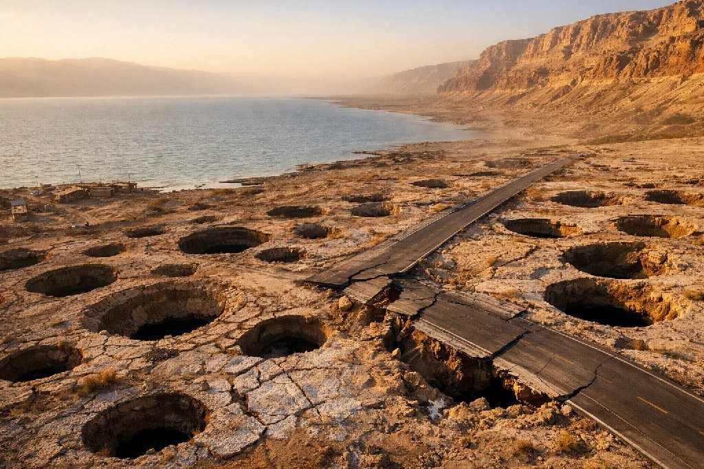
Since the 1980s, more than 6,000 sinkholes have formed along a 60-kilometer strip of Israel’s western Dead Sea coast, appearing at a rate exceeding 400 per year. They form without visible warning. A road looks structurally sound at dawn and collapses by midday. A resort stands on solid ground one season and sits over a growing underground cavity the next. At Kibbutz Ein Gedi alone, documented losses exceeded $25 million USD. The Arab Potash Company in neighboring Jordan faces projected damages of $70–90 million USD from sinkhole activity near its industrial operations.
For governments, engineers, and infrastructure operators in the region, the question was not whether the next sinkhole would form. It was whether anyone could identify where and when before catastrophic collapse.
The answer came from space.
The Problem: Infrastructure Built Over a Collapsing Landscape
The geology driving this crisis is relentless. As the Dead Sea shrinks, its shoreline retreats eastward and the freshwater aquifer follows. That freshwater — now undersaturated relative to the ancient salt deposits buried beneath the shoreline sediments — begins dissolving those deposits from below. Underground cavities grow silently for months or years, hidden under meters of gravel and clay, until the surface above can no longer hold its own weight and collapses.
The result is karst sinkhole hazard operating at industrial scale: sinkholes reaching 27 meters deep and 50 meters wide, clustering in active zones up to 1 kilometer wide, positioned directly alongside Israel’s main highway, tourist infrastructure, agricultural operations, and potash production facilities.
For construction and infrastructure planning, sinkholes represent one of the most dangerous and least predictable geohazards in existence. Unlike earthquakes or floods, which affect large areas simultaneously, sinkholes strike individual points with extreme force and almost no surface warning. A foundation that passed every standard geotechnical test at the time of construction can be undermined years later as groundwater conditions shift. A road reinforced against subsidence can have a 9-meter cavity develop directly beneath its reinforcement layer — invisible to any inspection conducted above ground.
| Infrastructure Type | Sinkhole Risk | Consequence of Collapse | Detection Without Satellite |
|---|---|---|---|
| Highways & Roads | Very High | Sudden collapse, casualties, closures lasting years | Only after visible surface cracks appear |
| Industrial Pipelines | Very High | Rupture, spills, production halt, worker safety risk | Practically impossible in active sinkhole zones |
| Buildings & Foundations | High | Structural failure, evacuation, total loss | First signs: door frames, wall cracks — already too late |
| Tourist & Resort Facilities | High | Closure, liability, permanent revenue loss | Visual inspection only — insufficient |
| Agricultural Land | Medium–High | Loss of productive area, irrigation system damage | Seasonal surveys — too infrequent |
Before the GSI’s satellite program existed, the only available response was reactive: close the road after the collapse, evacuate the building after the crack, reroute the pipeline after the failure. There was no operational sinkhole early warning system capable of monitoring the entire coastline continuously and detecting movement before it became catastrophic.
The Solution: Systematic Sinkhole Monitoring with Satellite Radar
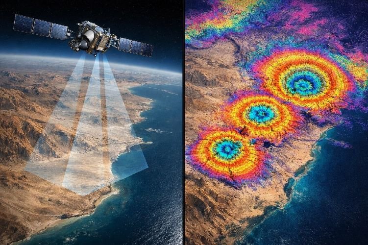
The Geological Survey of Israel (GSI) built and operated one of the most scientifically documented satellite geohazard monitoring programs in the world — a continuous, semi-automated sinkhole monitoring with satellite radar system that ran for more than six years along the Dead Sea’s western shore.
Satellites used: COSMO-SkyMed constellation (Italian Space Agency), X-band radar at 3.1 cm wavelength, acquiring imagery every 16 days from both ascending and descending orbital passes. The dual-orbit approach allowed the GSI to separate vertical from horizontal deformation components — critical for understanding whether ground was sinking straight down or moving laterally toward the shoreline.
Precision enhancement: Airborne LiDAR data at 0.5-meter spatial resolution was integrated directly into the InSAR processing pipeline as a high-accuracy digital surface model. This eliminated topographic phase errors that would otherwise corrupt deformation measurements in the complex, irregular terrain of the Dead Sea shoreline.
Detection capability: The system reliably identified sinkhole subsidence detection at rates as low as approximately 1 mm/day — movement completely invisible to any surface inspection, undetectable by any ground-based instrument without direct placement over the subsiding area, but clearly measurable from 620 kilometers above Earth in a satellite orbit.
The scientifically critical insight behind the entire program is that sinkholes are not instantaneous events. They are the final stage of a prolonged underground process. As dissolution cavities expand, the sediments above begin compacting and deflecting downward — sometimes days before collapse, sometimes months, and in documented cases along the Dead Sea, nearly five years before the surface finally gives way. This precursory phase produces a distinct pattern of ground deformation before sinkhole collapse that InSAR captures with millimeter precision and maps spatially across areas that would be impossible to instrument on the ground.
How the GSI InSAR Sinkhole Monitoring System Worked
COSMO-SkyMed captures X-band radar imagery every 16 days from ascending and descending orbits across the entire western Dead Sea coastline.
Airborne LiDAR digital surface model (0.5 m resolution) is used to remove topographic phase errors from InSAR interferograms, enabling millimeter-level deformation accuracy.
Interferograms are processed to produce color-coded deformation maps showing movement rates across the entire monitored corridor. Areas subsiding at ≥1 mm/day are flagged for review.
Time-series analysis monitors whether subsidence rates are stable, accelerating, or decelerating — the acceleration signal is the most critical precursor to imminent collapse.
When acceleration crosses defined thresholds, GSI issues a formal alert to the relevant infrastructure authority, with InSAR maps attached as evidence and routing guidance.
Quantifiable Results: Three Outcomes That Prove the System Works
Road 90, En Gedi: A 2-Year Warning Before Catastrophic Collapse
Road 90 is Israel’s longest highway, running along the western Dead Sea shore through the heart of the most active sinkhole risk for infrastructure corridor in the country. A cluster of sinkholes had been intermittently active near En Gedi since the mid-1990s. In 2002, geosynthetic reinforcement sheets were placed approximately one meter beneath the road surface at the point where the active sinkhole lineament crossed the highway — a precautionary measure that bought time but addressed the symptom, not the cause.
The GSI was monitoring this section with InSAR continuously. The timeline of what happened next is the clearest demonstration of what sinkhole precursors detection from satellite makes possible:
The road surface continued subsiding at approximately 2 mm/day after closure and experienced further collapses along its margins through late 2017 — confirming that the October 2012 InSAR alert captured an early stage of a multi-year failure sequence. Without satellite monitoring, the first indication of the problem would have been the collapse itself.
Dead Sea Works Pipeline, Ze’elim Fan: Routing a Critical Industrial Asset Away from Active Collapse
Dead Sea Works (DSW), Israel’s largest potash producer, needed to install a new pumping station and water conduit system across the Ze’elim alluvial fan — statistically one of the most geologically active sinkhole zones along the entire coastline. The Ze’elim fan covers approximately 250 square kilometers and had documented dozens of new sinkholes forming between 2011 and 2016 alone.
Three routing alternatives were under evaluation, two of them traversing the southern portion of the fan. The GSI’s continuous satellite monitoring for ground stability across the entire fan area provided unambiguous data: active InSAR subsidence mapping showed ongoing deformation surrounding both southern candidate sites and the pipeline corridors that would have been required to connect them to the evaporation ponds.
The GSI formally recommended the northern alternative — a route that the InSAR data confirmed was outside the active subsidence perimeter. Dead Sea Works accepted the recommendation. The northern route was selected, constructed, and placed into operation, with GSI continuing to monitor the full construction corridor and pipeline track throughout the build phase and beyond.
The alternative — routing a critical industrial water conduit through a documented active collapse zone — would have exposed DSW’s production infrastructure to progressive ground failure, potential pipe rupture, worker safety incidents, and production interruptions in a facility that the company’s own senior management described as existentially important to the regional economy.
The Regulatory Outcome: InSAR Becomes a Legal Requirement
The most durable result of the GSI program is institutional. InSAR subsidence mapping produced by the Geological Survey of Israel is now formally incorporated into all karst sinkhole hazard assessment maps along the Dead Sea coast in Israel — and those maps carry legal weight. No road, pipeline, industrial facility, or permanent structure can receive construction approval in the zone without InSAR-validated ground stability data as a mandatory component of the planning submission.
A technology that began as a scientific research initiative is now embedded in national infrastructure law. The system proved its value not once but repeatedly, across multiple asset types, over more than six years of continuous operation.
How SkyIntelGroup Delivers This Capability Globally
The Dead Sea case is exceptional in its scale and documentation — but the underlying geology is not unique to Israel. Karst sinkhole hazard zones cover approximately 15% of Earth’s ice-free land surface, spanning large portions of the United States, the United Kingdom, Spain, Mexico, China, and the Middle East. Anywhere soluble rock — limestone, dolomite, gypsum, or salt — lies beneath populated or industrialized terrain, the threat profile is the same: invisible underground dissolution, gradual surface deformation, and eventual catastrophic collapse with little or no warning detectable at ground level.
At SkyIntelGroup, we deploy the same InSAR-based monitoring stack the GSI used in Israel — COSMO-SkyMed and Sentinel-1 data processing, millimeter-precision deformation time series, LiDAR-enhanced accuracy where available — as a commercial service for construction firms, infrastructure operators, government agencies, and insurers anywhere in the world.
For a construction firm planning infrastructure in a karst environment, we provide pre-construction sinkhole risk for infrastructure assessment using historical satellite archives extending back over a decade — revealing whether a site has been stable or subsiding long before the first engineer visits the field. For operators managing existing assets in active sinkhole zones, we provide continuous monitoring with defined alert thresholds, so acceleration events like the one that triggered the Road 90 warning in September 2012 generate immediate notification rather than being discovered after the fact.
As we documented in our analysis of Florida’s sinkhole challenge, this approach works equally in suburban karst environments where traditional ground-based methods cannot deliver coverage at the required scale. The technology is the same. The physics are the same. What changes is the geography — and we operate globally.
Is Your Infrastructure Built Over a Sinkhole Risk Zone?
SkyIntelGroup delivers satellite-based sinkhole early warning and ground stability monitoring for construction firms, government agencies, and industrial operators worldwide. Millimeter precision. No boots on the ground required.
Verified Source Links
- Nof, R.N. et al. (2019). SAR Interferometry for Sinkhole Early Warning and Susceptibility Assessment along the Dead Sea, Israel. Remote Sensing, 11(1), 89. https://www.mdpi.com/2072-4292/11/1/89
- Nof, R.N. et al. (2013). Sinkhole precursors along the Dead Sea, Israel, revealed by SAR interferometry. Geology, 41(9), 1019–1022. https://pubs.geoscienceworld.org/gsa/geology/article/41/9/1019/131304
- Baer, G. et al. (2018). InSAR Measurements and Viscoelastic Modeling of Sinkhole Precursory Subsidence. Remote Sensing of Environment. https://www.researchgate.net/publication/323989582
- Times of Israel. On land crumbled by sinkholes, Dead Sea locals try to shore up their livelihoods. https://www.timesofisrael.com/on-land-crumbled-by-sinkholes-dead-sea-locals-try-to-shore-up-their-livelihoods/
- ResearchGate. InSAR-based modeling and analysis of sinkholes along the Dead Sea coastline. https://www.researchgate.net/publication/282941756_InSAR-based_modeling_and_analysis_of_sinkholes_along_the_Dead_Sea_coastline