How InSAR Detected 37 cm/Year Subsidence in Iran’s Pistachio Capital: The Rafsanjan Crisis
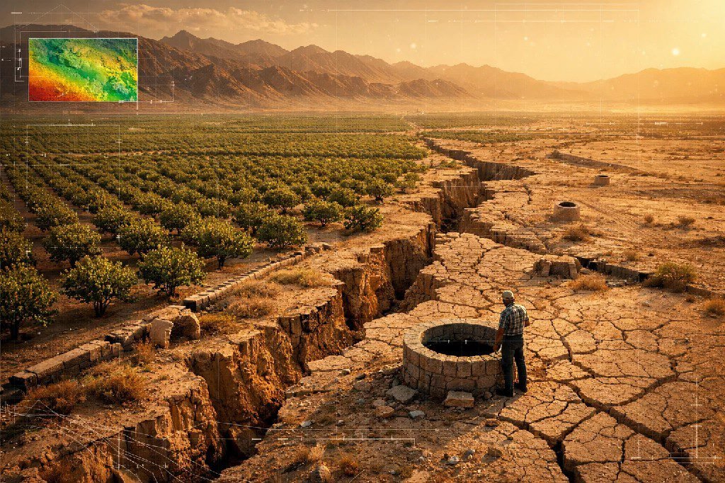
Beneath the sprawling pistachio orchards of Rafsanjan, Iran, one of the world’s most valuable agricultural regions is slowly sinking into the earth. For decades, the ground movement remained invisible to farmers, policymakers, and infrastructure managers. Traditional monitoring methods could only capture isolated points, missing the regional scale of the crisis.
Then satellite radar changed everything.
A groundbreaking study using satellite subsidence monitoring agriculture applications revealed what no ground survey could: Rafsanjan is experiencing the highest land subsidence rate in Iran, with locations sinking at an astonishing 37 centimeters per year. This case study examines how InSAR technology uncovered a hidden crisis threatening a billion-dollar industry and what it means for agricultural regions worldwide facing similar groundwater challenges.
The Crisis Underground: Six Decades of Invisible Decline
Rafsanjan District in Kerman Province represents the heart of global pistachio production. This semi-arid region produces approximately 18-20% of the world’s pistachios, generating nearly $1 billion annually and employing over 30,000 people directly in orchard management. More than 90% of agricultural land in the region is dedicated to this single crop.
The region’s success, however, has been built on an unsustainable foundation.
Since the 1960s, pistachio irrigation has relied almost exclusively on groundwater extraction. The numbers tell a troubling story: where 226 traditional qanats once sustainably delivered water to orchards, today more than 1,445 registered wells pump water from depths that continue to increase. The aquifer recharge rate simply cannot keep pace with extraction — the region withdraws approximately 160-200 million cubic meters per year more than natural replenishment provides.
The consequences were accumulating silently underground. The groundwater table dropped from approximately 20 meters below surface in the 1980s to over 300 meters in some areas today. Between 1983 and 2016 alone, the regional water table fell by 17 meters. As farmers drilled deeper wells to chase the retreating water, many encountered increasingly saline water unsuitable for irrigation, forcing them to abandon productive orchards.
But the most dangerous consequence remained invisible: the land itself was compacting and sinking as aquifer systems collapsed under the reduced hydraulic pressure.
Traditional monitoring approaches — sporadic leveling surveys, isolated GPS stations, visual inspections — could only capture fragments of this regional phenomenon. Infrastructure damage appeared seemingly at random: cracked roads, tilted structures, damaged well casings. Without comprehensive spatial data, authorities could not distinguish localized problems from systemic regional subsidence.
The region needed a way to see the invisible.
Sentinel-1 Reveals the Invisible: A National-Scale Satellite Survey
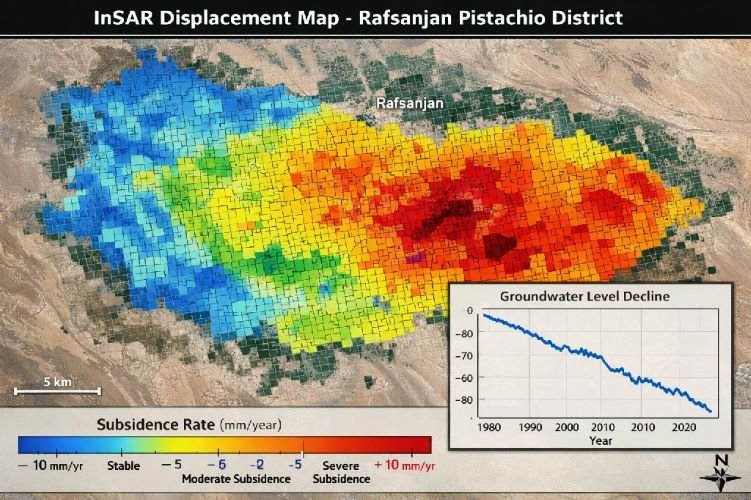
In 2024, researchers from the GFZ German Research Centre for Geosciences and Leibniz University Hannover published what would become a landmark study in Science Advances. Led by Dr. Mahmud Haghshenas Haghighi and Professor Mahdi Motagh, the team deployed Interferometric Synthetic Aperture Radar (InSAR) technology to create the first comprehensive subsidence map of Iran at unprecedented resolution.
The methodology was ambitious in scope. The research team processed more than 6,000 Sentinel-1 satellite images acquired between 2014 and 2020. Using differential InSAR techniques, they measured ground displacement across the entire country at 100-meter resolution — detailed enough to identify individual agricultural areas while comprehensive enough to reveal regional patterns.
InSAR Survey Technical Specifications
The Sentinel-1 constellation, operated by the European Space Agency, provided consistent radar coverage regardless of weather conditions or daylight — critical for a region where cloud-free optical imagery cannot be guaranteed. The C-band SAR sensors penetrated atmospheric conditions that would blind optical satellites, delivering reliable measurements across seasons and years.
Building on earlier work using Envisat, ALOS, and TerraSAR-X data from 2004 to 2016, the research team could establish long-term subsidence trends and validate their Sentinel-1 findings against ground-based leveling measurements. This multi-sensor approach ensured that the dramatic results were not artifacts of a single data source.
The InSAR processing chain identified surface deformation by measuring phase differences between successive radar acquisitions. When the ground surface moves between satellite passes, the radar signal returns with a slightly different phase — a difference measurable to millimeter precision. By stacking hundreds of interferograms and applying advanced atmospheric correction techniques, the team isolated true ground deformation from noise.
For Rafsanjan specifically, the dense time series revealed not only annual subsidence rates but also seasonal patterns reflecting the elastic response of aquifer systems to pumping cycles. This distinction between permanent (inelastic) compaction and recoverable (elastic) deformation provided crucial insights into aquifer health and the sustainability of current extraction rates.
The Numbers That Changed Everything: Quantifying Agricultural Subsidence
When the subsidence map was complete, Rafsanjan stood out immediately. The district recorded the highest subsidence rate anywhere in Iran: locations sinking at 37 centimeters per year. Neighboring Arzuiyeh county followed closely at 34 cm/year. These rates rank among the most severe documented anywhere in the world.
Rafsanjan Subsidence: Key Findings
| Maximum Subsidence Rate | 37 cm/year |
| Area with >5 cm/year Subsidence | ~1,000 km² |
| Groundwater Table Decline (1983–2016) | 17 meters |
| Irreversible Aquifer Storage Loss | 8.8 km³ |
| Annual Groundwater Deficit | ~160–200 million m³ |
| Potential Subsidence Reduction by 2050 | Up to 50% |
The national perspective was equally alarming. Across Iran, approximately 56,000 km² — 3.5% of the country’s total land area — showed active subsidence linked primarily to agricultural groundwater extraction. More than 3,000 km² experienced rates exceeding 10 cm/year. The Central Plateau basin, which includes Rafsanjan, accounts for 70% of the country’s total groundwater depletion.
Perhaps most concerning was the finding regarding aquifer compaction sustainability. The research team calculated the ratio between elastic (seasonal, recoverable) and inelastic (permanent) deformation. For most Iranian aquifers, including Rafsanjan, the long-term permanent compaction was approximately ten times larger than seasonal elastic response. This indicates that aquifer storage capacity is being permanently destroyed, not merely temporarily stressed.
The cumulative impact on water storage is staggering. Numerical modeling calibrated with InSAR data estimated that Rafsanjan’s aquifer system has already suffered an irreversible storage capacity loss of 8.8 cubic kilometers. This water storage capacity is gone permanently — no amount of reduced pumping or artificial recharge can restore it.
The infrastructure implications extend far beyond agriculture. The Science Advances study identified that across Iran, eight major airports, 54 railway stations, 25 metro stations, and thousands of kilometers of roads pass through active subsidence zones. While Rafsanjan’s own infrastructure density is lower than Tehran’s or Isfahan’s, the regional road network, irrigation infrastructure, and rural housing all face ongoing damage from differential settlement.
From Crisis Detection to Sustainable Management
The Rafsanjan study demonstrates both the power and the practical value of satellite-based subsidence monitoring for agricultural regions. Beyond documenting the crisis, the InSAR data enabled forward-looking scenario modeling.
Researchers used the validated subsidence measurements to calibrate groundwater flow models that could project future conditions under different management scenarios. Their findings offered a path forward: implementation of improved irrigation management for pistachio orchards could reduce subsidence rates by up to 50% and decrease aquifer storage capacity loss by 36% by 2050.
This projection depends on transitioning from flood irrigation to precision methods, reducing overall water application, and potentially shifting some land away from water-intensive cultivation. None of these changes would be possible without first understanding the spatial extent and severity of the problem — understanding that only satellite monitoring could provide at this scale.
The continuous nature of InSAR monitoring also enables adaptive management. Rather than relying on periodic ground surveys, authorities can track whether interventions are working, identify areas where subsidence is accelerating despite management changes, and adjust strategies accordingly. This feedback loop transforms subsidence monitoring from a one-time assessment into an ongoing management tool.
How SkyIntelGroup Delivers Agricultural Subsidence Intelligence
The Rafsanjan case illustrates exactly the type of challenge that SkyIntelGroup addresses for agricultural operations, infrastructure managers, and government agencies worldwide. Our DInSAR monitoring services provide the same millimeter-precision ground deformation detection demonstrated in the GFZ research — delivered as actionable intelligence for your specific operational needs.
Where the Rafsanjan study required years of academic research to process and interpret, SkyIntelGroup delivers operational subsidence monitoring on timelines that support real decision-making. Our team processes Sentinel-1 and commercial SAR data to generate subsidence maps, time series analysis, and trend projections tailored to your area of interest.
For agricultural regions dependent on groundwater, we provide:
- Baseline assessment establishing current subsidence rates across irrigation districts
- Continuous monitoring tracking changes month-over-month and year-over-year
- Hotspot identification pinpointing areas of accelerating subsidence before infrastructure damage occurs
- Aquifer sustainability analysis comparing elastic versus inelastic deformation patterns
Our services extend beyond agriculture to construction, infrastructure, and urban environments — anywhere ground stability affects operations and investment decisions. The same InSAR techniques that revealed Rafsanjan’s crisis can protect your assets from similar hidden threats.
Protect Your Agricultural Investment
Ground subsidence threatens irrigation infrastructure, crop yields, and long-term land value. SkyIntelGroup’s satellite monitoring detects millimeter-scale movement before damage becomes visible.
Lessons for Global Agriculture
Rafsanjan is not unique. Groundwater-dependent agricultural regions across the globe face similar trajectories: the Central Valley of California, the North China Plain, the Indo-Gangetic Basin, parts of Spain and Australia. Each shares the fundamental challenge of extraction exceeding recharge, and each faces the same invisible threat of land subsidence.
The Rafsanjan case offers three critical lessons applicable worldwide:
First, subsidence can remain undetected until damage becomes severe. Traditional monitoring methods lack the spatial coverage to identify regional patterns. By the time individual structures show visible damage, aquifer compaction may already be irreversible across thousands of square kilometers.
Second, satellite monitoring transforms subsidence from an invisible threat into a measurable, manageable phenomenon. The same InSAR techniques that documented Rafsanjan’s crisis can provide early warning for other regions — enabling intervention before permanent aquifer damage occurs.
Third, the data enables action. Without quantified subsidence rates and spatial patterns, policymakers cannot prioritize interventions, farmers cannot evaluate the sustainability of their practices, and infrastructure planners cannot account for ongoing ground movement. The Rafsanjan study’s scenario modeling demonstrates how monitoring data translates directly into management recommendations.
For agricultural enterprises, water authorities, and infrastructure managers in groundwater-dependent regions, the question is no longer whether satellite subsidence monitoring is valuable — the Rafsanjan case answers that definitively. The question is whether your organization will have the data it needs before subsidence causes irreversible damage.
Start Monitoring Before It’s Too Late
SkyIntelGroup delivers the same InSAR technology used in the Rafsanjan study — configured for your operational needs and delivered on your timeline.
Verified Source Links
Haghshenas Haghighi, M., & Motagh, M. (2024). Uncovering the impacts of depleting aquifers: A remote sensing analysis of land subsidence in Iran. Science Advances, 10(19), eadk3039. https://www.science.org/doi/10.1126/sciadv.adk3039
Motagh, M., et al. (2017). Quantifying groundwater exploitation induced subsidence in the Rafsanjan plain, southeastern Iran, using InSAR time-series and in situ measurements. Engineering Geology, 218, 134-151. https://www.researchgate.net/publication/312575115
Bockstiegel, M., et al. (2024). Simulation of present and future land subsidence in the Rafsanjan plain, Iran, due to groundwater overexploitation using numerical modeling and InSAR data analysis. Hydrogeology Journal, 32, 289-305. https://link.springer.com/article/10.1007/s10040-023-02657-y
GFZ German Research Centre for Geosciences. (2024). Iran’s groundwater crisis and subsidence come to a head. https://www.gfz.de/en/press/news/details/grundwasserkrise-und-bodenabsenkung-in-iran-spitzt-sich-zu
Akhavan, A., & Gonçalves, P. (2021). Managing the trade-off between groundwater resources and large-scale agriculture: the case of pistachio production in Iran. System Dynamics Review, 37(2-3), 155-196. https://onlinelibrary.wiley.com/doi/full/10.1002/sdr.1689