Satellite Subsidence Monitoring in Miami Beach: How InSAR Detected Ground Movement in 35 Luxury High-Rises
The June 2021 collapse of Champlain Towers South in Surfside claimed 98 lives and fundamentally changed how Florida approaches building safety. In the aftermath, state legislators enacted Senate Bill 4-D mandating structural inspections for buildings three stories or higher, with milestone assessments required at 25–30 years of age. Yet traditional visual inspections face an inherent limitation: they cannot detect the millimeter-scale ground movements that may precede structural distress.
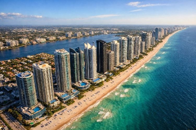
A landmark December 2024 study published in Earth and Space Science by researchers from the University of Miami, GFZ German Research Centre for Geosciences, and multiple international institutions demonstrated that satellite-based Interferometric Synthetic Aperture Radar (InSAR) can fill this critical gap. Their analysis revealed that 35 luxury high-rises along Miami’s barrier islands have subsided by 2–8 centimeters since 2016—movements invisible to the naked eye but clearly measurable from 700 kilometers above Earth.
For property owners, insurers, and developers managing billions of dollars in coastal real estate, this research validates what SkyIntelGroup has long understood: satellite remote sensing for construction monitoring delivers structural intelligence that ground-based methods simply cannot match.
The Challenge: Invisible Ground Movement Threatening Billions in Coastal Real Estate
The Scale of Risk in South Florida’s Coastal Corridor
Miami’s barrier islands present a unique geological challenge. Unlike cities built on solid bedrock, South Florida sits atop porous limestone interspersed with sandy layers—a substrate particularly susceptible to compaction under structural loads. The region’s post-2014 construction boom introduced dozens of towers exceeding 50 stories, each imposing sustained pressure on this vulnerable geology.
The problem compounds when construction vibrations from new developments affect neighboring structures. Pile driving, excavation, and dewatering operations transmit energy through the ground, potentially triggering settlement in buildings hundreds of meters away. Traditional inspection protocols—even the enhanced milestone inspections mandated by Florida’s SB 4-D—rely primarily on visual assessment of cracks, spalling, and structural distress. These methods detect damage after it manifests, not the slow ground movements that precede it.
Why Traditional Inspections Miss Critical Precursors
Visual inspections excel at identifying obvious deterioration: corroded rebar, concrete delamination, water intrusion damage. However, ground subsidence at rates of 2–4 millimeters per year remains entirely invisible until differential settlement causes structural cracking—by which point, remediation costs have multiplied significantly.
The Champlain Towers investigation itself highlighted this limitation. While the collapse was attributed to reinforced concrete deterioration from decades of deferred maintenance rather than ground settlement, the tragedy underscored a fundamental truth: reactive inspection regimes cannot substitute for continuous monitoring of structural behavior.
For the luxury condominium market along Collins Avenue—where individual units routinely exceed $5 million and entire buildings represent hundreds of millions in assessed value—this inspection gap represents an unacceptable risk exposure.
The Solution: Satellite Subsidence Monitoring in Miami Beach with InSAR Technology
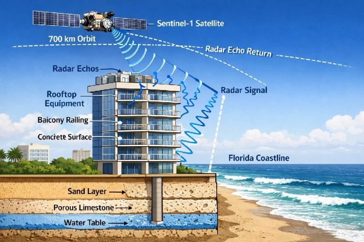
The University of Miami research team, led by Dr. Farzaneh Aziz Zanjani and senior author Professor Falk Amelung, deployed Interferometric Synthetic Aperture Radar to examine a 15-kilometer coastal strip from Sunny Isles Beach through Bal Harbour, Surfside, and Miami Beach. Their methodology demonstrates the operational maturity of satellite subsidence monitoring in Miami Beach and similar coastal environments.
How InSAR Detects Millimeter-Scale Building Movement
InSAR operates by comparing radar signals from the European Space Agency’s Sentinel-1 satellites captured on successive orbital passes. When the satellite transmits microwave pulses toward Earth, fixed objects on building surfaces—balconies, rooftop air conditioning units, metal railings, boardwalks—reflect these signals back to the sensor. By measuring the phase difference between signals acquired at different times, analysts can calculate surface displacement with millimeter precision.
The research team processed 222 Sentinel-1 SAR images spanning 2016–2023, creating a continuous displacement time series for each identifiable reflector along the coastline. To validate their findings, collaborators at GFZ German Research Centre for Geosciences and Leibniz University Hannover independently analyzed 121 additional images from the German TerraSAR-X satellite, confirming the Sentinel-1 results.
Technical Specifications: Miami Barrier Islands InSAR Study
Primary Dataset: Sentinel-1
- Images processed: 222
- Time span: 2016–2023
- Revisit frequency: 6–12 days
- Spatial resolution: 5 × 20 meters
- Band: C-band (5.6 cm wavelength)
Validation Dataset: TerraSAR-X
- Images processed: 121
- Time span: 2017–2021
- Spatial resolution: 1–3 meters
- Band: X-band (3.1 cm wavelength)
- Purpose: Independent confirmation
Persistent Scatterers: Transforming Buildings into Measurement Points
The technique relies on identifying «persistent scatterers»—stable radar-reflective features that maintain consistent signal characteristics across years of observations. In urban coastal environments, these typically include metal structural elements, concrete edges, and rooftop equipment. Each high-rise effectively becomes a network of measurement points, enabling analysts to track not just whether a building is moving, but which sections are moving and at what rate.
The research team employed both Persistent Scatterer (PS) and Distributed Scatterer (DS) analysis techniques, processing data through multiple software platforms including the open-source SARvey system developed at GFZ and the established SARPROZ commercial package. This multi-method approach ensured robust results across varying surface conditions.
Quantified Results: 35 Buildings, Up to 8 cm Subsidence Over 7 Years
The findings revealed widespread subsidence concentrated in Sunny Isles Beach, with progressively fewer affected structures moving southward toward Miami Beach. This geographic pattern correlates strongly with two factors: the concentration of post-2014 construction and the local geology featuring thicker sand deposits within the limestone matrix.
Geographic Distribution of Detected Subsidence
Subsidence Detection by Coastal Zone (2016–2023)
| Zone | Total Buildings | With Subsidence | Affected % |
|---|---|---|---|
| Sunny Isles Beach (North/Central) | 87 | 33 | 67% |
| Surfside | 27 | 9 | 33% |
| Bal Harbour | 18 | 1 | 6% |
| Miami Beach | 110 | 2 | 2% |
The contrast is striking. In northern and central Sunny Isles Beach, two-thirds of coastal high-rises showed measurable subsidence. In Miami Beach—despite having the largest number of structures—only two buildings exhibited subtle, localized settlement signals over the seven-year observation period.
Notable Affected Properties
The 35 buildings identified include some of South Florida’s most recognizable luxury addresses:
- Porsche Design Tower: 10–12 cm line-of-sight displacement (2017–2021), the most significant movement detected
- Trump International Beach Resort and Trump Tower III
- Ritz-Carlton Residences Sunny Isles Beach
- Surf Club Four Seasons (North Tower, South Tower, Hotel Tower)
- Fendi Chateau and Faena House
- Acqualina Resort, Mansions at Acqualina, and Estates at Acqualina
- Jade Ocean, Jade Beach, and Jade Signature Condominiums
- Oceana Bal Harbour
- 87 Park Tower (Surfside)
Lead author Dr. Aziz Zanjani characterized the findings as unexpected: «The discovery of the extent of subsidence hotspots along the South Florida coastline was unexpected. The study underscores the need for ongoing monitoring and a deeper understanding of the long-term implications for these structures.»
The Construction-Subsidence Correlation
A critical finding emerged from temporal analysis: subsidence onset correlates strongly with nearby construction activity. Buildings completed after 2014 showed the highest rates of settlement, consistent with compaction of sandy layers under sustained structural load. More significantly, older buildings within 200–300 meters of active construction sites also exhibited accelerated subsidence during and after neighboring development—suggesting that vibrations from pile driving and excavation propagate through the porous substrate to affect adjacent structures.
Professor Falk Amelung, the study’s senior author, emphasized the implications: «We found that subsidence in most high-rises slows down over time, but in some cases, it continues at a steady rate. This suggests that subsidence could persist for an extended period.»
Champlain Towers South: What InSAR Revealed
The research team specifically examined the Champlain Towers South site in Surfside, hoping to identify retrospective warning signs. Their conclusion: no precursory displacement was detected before the June 2021 collapse.
This finding carries important implications. First, it confirms that settlement was not the proximate cause of the collapse—consistent with subsequent engineering investigations that attributed the failure to deteriorated reinforced concrete in the pool deck and subgrade parking structure. Second, it highlights that while InSAR excels at detecting ground-related structural risks, it represents one component of a comprehensive monitoring strategy rather than a standalone solution.
The research team noted a technical limitation: the radar viewing geometry could not adequately image the specific building section where the collapse initiated, leaving some uncertainty in the historical record.
How SkyIntelGroup Delivers Continuous Structural Monitoring
The University of Miami study validates what forward-thinking property managers and developers increasingly recognize: periodic inspections cannot substitute for continuous monitoring of high-value structural assets. The buildings examined in this research represent collective assessed values in the billions of dollars. A single undetected settlement event causing differential movement could trigger structural damage requiring tens of millions in remediation—not to mention potential liability exposure and reputational harm.
SkyIntelGroup provides satellite-based construction and infrastructure monitoring services that deliver the same DInSAR capabilities demonstrated in this research, operationalized for commercial clients across the construction, real estate, and insurance sectors.
Advantages of Satellite Monitoring vs. Traditional Inspection
Traditional Inspection vs. SkyIntelGroup DInSAR Monitoring
| Capability | Traditional Visual Inspection | SkyIntelGroup DInSAR |
|---|---|---|
| Detection threshold | Visible damage (cm-scale cracks) | Millimeter-scale displacement |
| Monitoring frequency | Annual or milestone (10-year) | Every 6–12 days |
| Coverage area | Individual structure | Entire portfolios simultaneously |
| Historical analysis | Limited to inspection records | Archive data back to 2014+ |
| Weather dependency | Requires site access | All-weather, day/night operation |
| Operational disruption | Building access required | Completely remote |
For condominium associations navigating Florida’s new SB 4-D compliance requirements, satellite monitoring provides a valuable supplement to mandatory milestone inspections. While visual assessments satisfy regulatory obligations, DInSAR time-series analysis establishes behavioral baselines that enable early detection of anomalous movement patterns between inspection cycles.
Applications Across the Real Estate Lifecycle
SkyIntelGroup’s remote sensing solutions address multiple stakeholder needs:
Pre-Acquisition Due Diligence: Investors and developers can commission historical displacement analysis before purchasing coastal properties, identifying structures with settlement histories that may indicate elevated risk profiles.
Construction Impact Monitoring: General contractors and adjacent property owners can track ground movement during major construction projects, documenting baseline conditions and detecting any construction-induced settlement in neighboring structures.
Portfolio-Wide Surveillance: Institutional owners and property managers can monitor entire building portfolios from a single platform, prioritizing engineering attention toward assets exhibiting anomalous behavior.
Insurance Underwriting Support: Carriers can incorporate objective displacement data into risk models, moving beyond actuarial tables toward structure-specific stability assessments.
Protect Your Coastal Real Estate Investments
SkyIntelGroup delivers satellite-based structural monitoring that detects millimeter-scale ground movement across your entire portfolio—before visible damage occurs.
Verified Source Links
- Aziz Zanjani, F., Amelung, F., et al. (2024). InSAR Observations of Construction‐Induced Coastal Subsidence on Miami’s Barrier Islands, Florida. Earth and Space Science. https://agupubs.onlinelibrary.wiley.com/doi/10.1029/2024EA003852
- University of Miami Rosenstiel School. (2024). New Study Finds Subsidence Hotspots Impacting Buildings in South Florida. https://news.miami.edu/rosenstiel/stories/2024/12/new-study-finds-subsidence-hotspots-impacting-high-rise-buildings-in-south-florida.html
- GFZ German Research Centre for Geosciences. (2024). Satellite Radar Shows Construction-Related Coastal Subsidence in Florida. https://www.gfz.de/en/press/news/details/satellitenradar-zeigt-baubedingte-kuestensenkungen-in-florida
- Aziz Zanjani, F. et al. (2024). InSAR Displacement Data for Miami Barrier Islands. Zenodo. https://doi.org/10.5281/zenodo.12699617