Utilities
Advanced Utilities Monitoring & Asset Management Services
Satellite-based vegetation management, tower inspection, utility asset management, and power grid monitoring for reliable electrical utilities operations
Get StartedComprehensive Utilities Solutions Using Satellite Technology
SkyIntelGroup provides professional utilities monitoring services powered by advanced satellite remote sensing and AI analytics. Our solutions include vegetation management, utility asset management, tower inspection, and transmission line inspection to enhance grid reliability, reduce operational costs, and prevent outages for electrical utilities worldwide.
From power line inspection and utility mapping to grid resilience, grid modernization, and predictive maintenance analytics, our satellite-based technology delivers cost-effective data for informed decision-making. We serve electric utilities, transmission operators, and distribution companies with reliable monitoring solutions that reduce vegetation-related outages by 10-20% and cut inspection costs by up to 80%.
Our Utilities Monitoring & Grid Management Services
Vegetation Management & Encroachment Monitoring
Reduce outages and optimize vegetation management costs with satellite-based utility vegetation management monitoring that identifies tree encroachment, assesses clearance distances, and prioritizes trimming activities across transmission and distribution networks. With 56% of power interruptions caused by vegetation and $6 billion spent annually on management in the US alone, this service delivers 15-20% cost reduction.
Using multispectral NDVI analysis, SAR imaging, and AI tree detection algorithms, this monitoring identifies tree trimming power lines priorities, tracks vegetation growth rates, and verifies contractor work quality. Applied successfully by major utilities monitoring 500,000+ miles of powerlines, this technology enables predictive vegetation management, reducing vegetation-caused outages by 10-20% through proactive intervention.
Key Benefits
- 15-20% reduction in vegetation management costs
- 10-20% fewer vegetation-caused outages
- $6B annual US market with proven ROI
- 10X more cost-effective than drone/LiDAR surveys
- Monitors 500,000+ mile networks efficiently

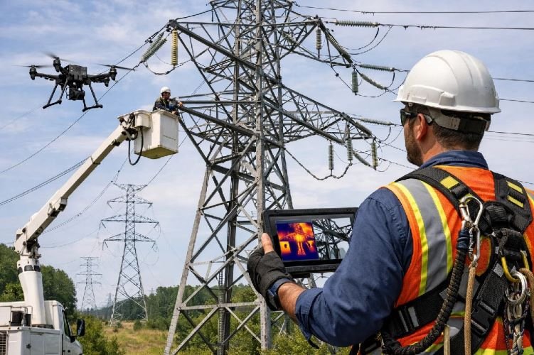
Transmission Tower & Infrastructure Inspection
Enhance safety and reduce inspection costs with satellite and drone-based tower inspection and transmission line inspection services. This technology replaces dangerous manual climbing and expensive helicopter surveys with high-resolution optical, thermal, and LiDAR imaging that detects structural defects, insulator damage, and conductor issues with AI-powered defect classification.
Proven in large-scale deployments including Saudi Electric Company (5,500 towers in 183 days vs 3 years traditional) and TransGrid Australia (13,000 km network), this service achieves 80% time reduction and 3X territory coverage compared to manual methods. Essential for power line inspection and utility inspection compliance, enabling condition-based maintenance and predictive failure prevention.
Key Benefits
- 80% reduction in inspection time
- 3X territory inspected vs traditional methods
- Eliminates dangerous manual tower climbing
- AI defect detection with thermal imaging
- Proven at 5,500+ tower scale deployments
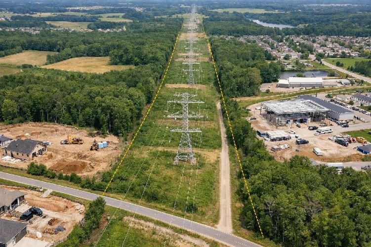
Right-of-Way Encroachment Detection
Protect critical utility corridors with automated detection of third-party encroachments, unauthorized construction, and vegetation incursions within transmission and distribution rights-of-way. Using high-resolution optical and SAR satellite imagery with AI-powered change detection, this service identifies new structures, equipment, excavation, and other activities threatening utility infrastructure safety and reliability.
Supported by European Space Agency funding and deployed by major utilities for regulatory compliance, this monitoring provides continuous surveillance of ROW corridors, enabling rapid response to unauthorized activities before they cause outages or safety incidents. Essential for preventing third-party damage, the leading cause of transmission line failures and safety violations globally.
Key Benefits
- Detects unauthorized construction and encroachment
- Prevents third-party damage to infrastructure
- ESA-funded technology with proven effectiveness
- Continuous ROW corridor surveillance
- Enables rapid response to violations
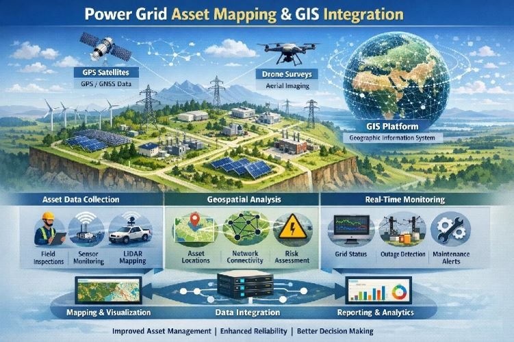
Power Grid Asset Mapping & GIS Integration
Build accurate utility asset inventories with AI-powered utility mapping that automatically detects and locates transmission towers, distribution poles, transformers, and conductors from high-resolution satellite imagery. This service creates comprehensive GIS databases, improving asset coverage from typical 70% accuracy to 98% completeness for optimized grid planning and operations.
Using deep learning algorithms for automatic tower and pole detection combined with SAR for all-weather mapping, this technology supports utility asset management, infrastructure planning, and digital twin development. Critical for utilities with incomplete or inaccurate asset records, enabling effective grid modernization, outage management system accuracy, and capital planning optimization.
Key Benefits
- Improves asset inventory from 70% to 98% accuracy
- $372 CPC for utility asset management keyword
- AI automatic detection of towers, poles, equipment
- Supports digital twin and GIS integration
- Enables accurate grid planning and operations
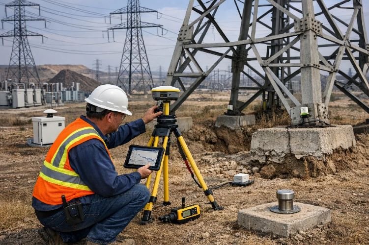
Ground Subsidence & Infrastructure Stability Monitoring
Prevent catastrophic infrastructure failures with millimeter-precision DInSAR monitoring of ground subsidence beneath transmission towers, substations, and critical utility assets. Using Persistent Scatterer Interferometry with Sentinel-1 SAR data, this service detects tower foundation movement, ground settlement, and structural instability caused by soil subsidence, mining activity, or groundwater extraction.
Applied by National Grid UK (£6 million annually for monitoring 1% of critical assets) and other major utilities, this technology enables predictive maintenance by identifying stability issues months before visible structural problems appear. Essential for protecting high-value assets, preventing tower collapse, and ensuring grid reliability in areas with subsidence risk.
Key Benefits
- Millimeter-precision subsidence detection
- National Grid UK £6M annual investment validated
- Prevents catastrophic tower and substation failures
- Monitors foundation stability continuously
- Enables predictive infrastructure maintenance
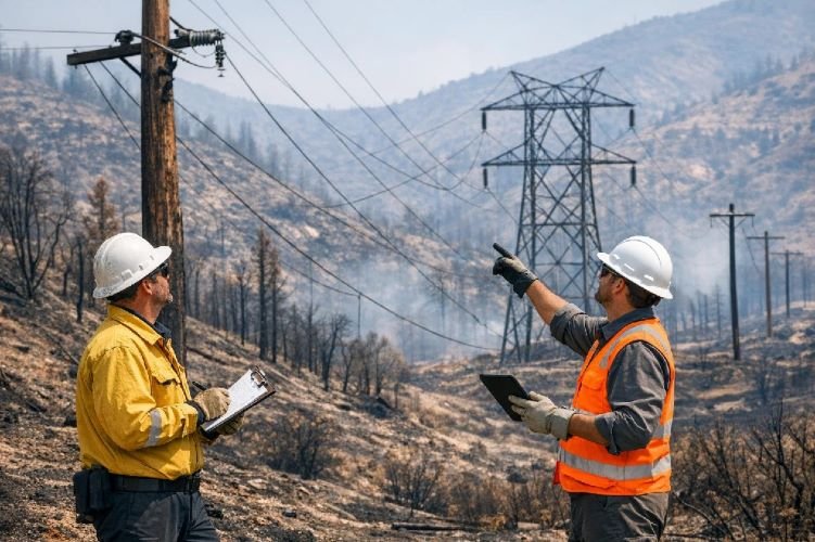
Wildfire Risk Assessment & Post-Fire Damage
Mitigate wildfire liability and accelerate recovery with thermal infrared wildfire risk assessment and post-fire infrastructure damage detection. This service evaluates vegetation fuel loads, identifies high-risk ignition zones near powerlines, monitors fire progression in real-time, and provides rapid post-fire damage assessment for restoration prioritization in wildfire-prone regions.
Critical for California utilities facing massive wildfire liability and applied by leading utilities for risk-based vegetation management, this monitoring supports fire prevention planning, emergency response coordination, and rapid restoration after fire events. Thermal satellite sensors detect fire starts, track perimeters, and assess infrastructure damage to minimize outage duration and safety risks.
Key Benefits
- Reduces wildfire liability exposure
- Identifies high-risk ignition zones
- Real-time fire progression tracking
- Rapid post-fire damage assessment
- Supports vegetation fuel load management
Storm Damage Assessment & Disaster Response
Accelerate power restoration with rapid post-storm damage assessment using high-resolution optical and all-weather SAR satellite imagery. This service identifies downed lines, damaged poles and towers, vegetation debris on infrastructure, and outage extent within hours of major weather events, enabling prioritized restoration and optimized crew deployment for faster power system reliability recovery.
Essential for hurricane, ice storm, tornado, and severe wind event response, this monitoring operates through cloud cover using SAR technology when optical imagery is unavailable. AI-powered damage classification automates assessment, providing immediate situational awareness for emergency operations centers and supporting grid resilience through rapid restoration planning and stakeholder communication.
Key Benefits
- Damage assessment within hours of storm events
- SAR operates through clouds and weather
- AI classification automates damage detection
- Optimizes restoration crew deployment
- Reduces customer outage duration significantly

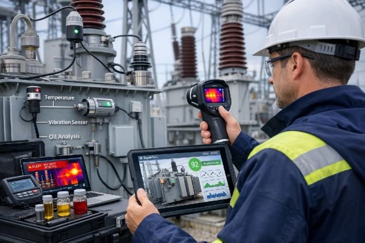
Predictive Maintenance & Asset Health Monitoring
Transform from reactive to proactive maintenance with thermal imaging hotspot detection, time-series condition analysis, and AI-powered asset health scoring. This service monitors transformer temperature, insulator integrity, conductor connections, and equipment degradation to predict failures before outages occur, extending asset life and reducing emergency repair costs through condition-based maintenance.
Supporting grid modernization initiatives and digital twin development, this monitoring integrates satellite thermal sensors with IoT ground sensors for comprehensive asset health intelligence. Applied by major utilities for predictive analytics, this technology identifies developing equipment failures weeks or months in advance, enabling planned maintenance during low-demand periods and preventing costly forced outages.
Key Benefits
- Predicts failures before outages occur
- Thermal imaging detects equipment hotspots
- AI health scoring for asset prioritization
- Extends asset life through optimal maintenance timing
- Reduces emergency repair costs significantly
Why Choose Satellite-Based Utilities Solutions?
Dramatic Cost Reduction
Achieve 15-20% vegetation management cost savings, 80% inspection time reduction, and 10X cost advantage over drone/helicopter surveys. Satellite technology enables comprehensive network monitoring at a fraction of traditional ground-based and aerial inspection costs.
Enhanced Grid Reliability
Reduce vegetation-caused outages by 10-20%, prevent third-party damage, and detect infrastructure stability issues months before failures. Predictive monitoring enables proactive maintenance, preventing outages rather than reacting to them after customer impact.
Safety & Compliance
Eliminate dangerous manual tower climbing, ensure ROW compliance, reduce wildfire liability, and maintain regulatory inspection requirements. Satellite monitoring provides objective evidence for regulators while protecting worker safety and reducing risk exposure.
Ready to Transform Your Utilities Operations?
Join leading electric utilities worldwide using satellite technology for vegetation management, tower inspection, and grid monitoring to reduce costs, prevent outages, and enhance grid reliability.
Contact Us Today