Forestry
Advanced Forestry Monitoring & Management Services
Satellite-based forest inventory, wildfire detection, harvest planning, and timber management for sustainable forestry operations worldwide
Get StartedComprehensive Forestry Solutions Using Satellite Technology
SkyIntelGroup provides professional forestry monitoring services powered by advanced satellite remote sensing and AI analytics. Our solutions include forest inventory, wildfire detection, harvest planning, and logging monitoring to optimize sustainable forest management, reduce operational costs, and ensure regulatory compliance for forestry operations globally.
From tree inventory and timber management to digital forestry, forest management services, and precision forestry analytics, our satellite-based technology delivers accurate, cost-effective data for informed decision-making. We serve commercial timber companies, forest owners, conservation organizations, and government forestry agencies with reliable monitoring and verification solutions.
Our Forestry Monitoring & Management Services
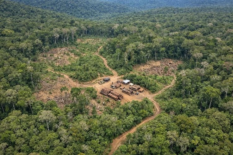
Illegal Logging Detection & Monitoring
Combat unauthorized timber harvesting with satellite-based logging monitoring that detects illegal logging camps, unauthorized roads, equipment, and forest clearing in protected areas or legal concessions. Using high-resolution optical imagery combined with cloud-penetrating SAR and AI-powered change detection, this service identifies clandestine logging activity in remote, inaccessible regions.
Proven effective in Peru (37% illegal logging detection), Indonesia (10X better than free platforms), and Amazon regions, this monitoring provides forensic evidence by comparing current imagery with 20-year historical archives. Applied successfully for timber concession verification, protected area surveillance, and law enforcement support, enabling rapid response to unauthorized forest exploitation.
Key Benefits
- 37% illegal logging detection improvement in Peru
- 10X better detection than free monitoring platforms
- Cloud-penetrating SAR for year-round surveillance
- Forensic evidence with 20-year archive comparison
- Enables enforcement in remote inaccessible areas
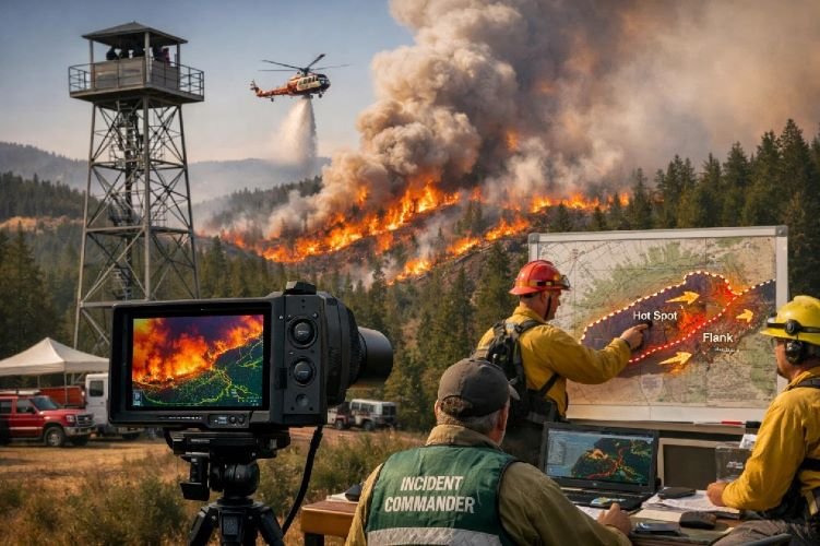
Wildfire Detection & Monitoring
Protect forest assets with advanced wildfire detection using thermal infrared satellite sensors that identify fires as small as 50m x 50m and provide fire perimeter updates every 10-20 minutes. This service integrates 25+ satellite data sources with AI-powered fire behavior modeling, delivering early warnings and real-time progression tracking for rapid emergency response.
Supporting the FireSat constellation (50 satellites by 2030) and proven technologies from OroraTech and NASA, this monitoring calculates Fire Radiative Power, predicts spread direction, and enables coordinated firefighting deployment. With CAL FIRE calling this «the biggest advance in fire technology of the century,» satellite wildfire detection is transforming forest fire management globally.
Key Benefits
- Detects fires as small as 50m x 50m
- Fire perimeter updates every 10-20 minutes
- Integrates 25+ satellite data sources with AI
- Fire spread prediction and behavior modeling
- Supports rapid emergency response coordination
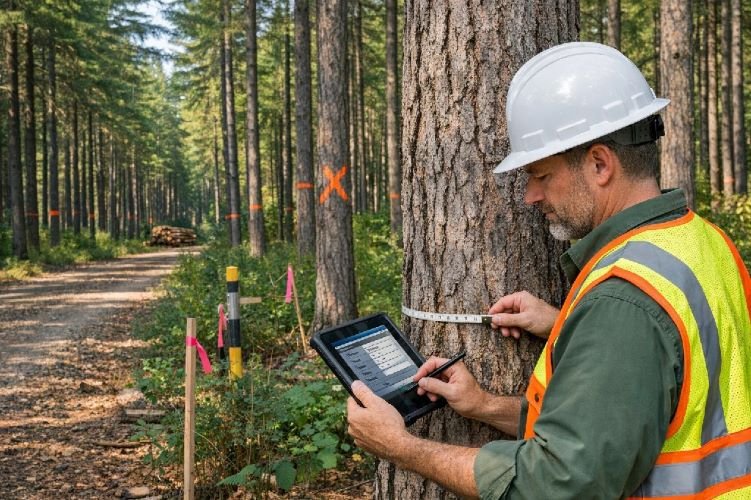
Forest Inventory & Timber Volume Estimation
Revolutionize forest inventory operations with satellite-based tree inventory that measures individual tree height, diameter, canopy density, and timber volume without expensive ground surveys. Using LiDAR, high-resolution optical imagery, and machine learning, this service delivers tree-level precision for commercial forest management and harvest planning.
Applied successfully in Canada, Finland, and Sweden for routine forest management plans, this technology replaces manual methods that cover less than 1% of forest area. With individual tree-level inventories enabling precision forestry, forestry companies optimize harvest timing, validate timber volumes, and improve fiber management for maximum economic return on forest investments.
Key Benefits
- Individual tree-level measurement precision
- Replaces manual surveys covering under 1% of area
- $1,171 CPC value for harvest planning keyword
- Measures height, DBH, volume, species remotely
- Enables precision forestry and harvest optimization
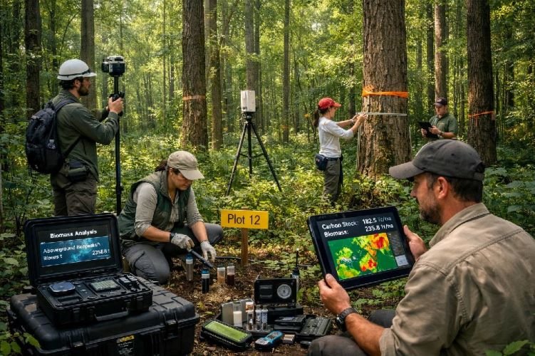
Forest Carbon Stock & Biomass Measurement
Monetize forest carbon potential with precise biomass measurement using ESA’s P-band SAR Biomass satellite (launched April 2025), NASA GEDI, and L-band SAR technology. This service quantifies aboveground biomass and carbon tons per hectare for forest carbon credits verification, REDD+ compliance, and voluntary carbon market participation.
With machine learning models achieving R² 0.97 accuracy combining satellite data, this monitoring enables tree-by-tree carbon accounting for forest stewardship and climate finance. Essential for carbon credit certification, ESG reporting, and demonstrating climate mitigation contributions, this technology unlocks carbon revenue from sustainable forest management while supporting global climate goals.
Key Benefits
- ESA P-band SAR penetrates dense tropical canopy
- R² 0.97 accuracy with machine learning models
- $174 CPC for forest carbon credits keyword
- Supports REDD+ and voluntary carbon markets
- Enables tree-by-tree carbon accounting
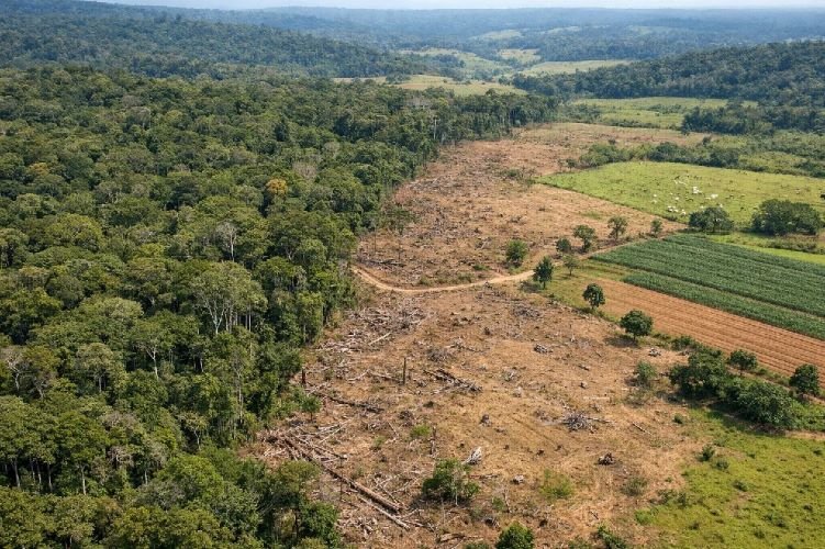
Deforestation Monitoring & Change Detection
Track global forest loss with daily deforestation monitoring using high-resolution optical and SAR satellite imagery. This service detects linear forest clearings, canopy loss, and land use changes with automated alerts delivered within 24 hours, enabling rapid response to unauthorized forest conversion in tropical and temperate regions experiencing 6.3 million hectares annual loss.
Powered by Planet’s daily global coverage, EarthDaily’s 22-band spectral analysis, and Global Forest Watch’s 70+ partner network, this monitoring supports forest certification, conservation enforcement, and compliance verification. Essential for sustainable supply chains, zero-deforestation commitments, and forest protection programs in high-pressure landscapes globally.
Key Benefits
- Daily global monitoring with automated alerts
- Detection alerts delivered within 24 hours
- Tracks 6.3M hectares annual global forest loss
- Supports zero-deforestation supply chain verification
- Integrated with Global Forest Watch platform
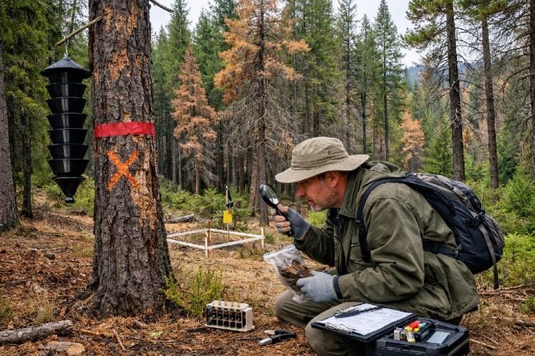
Forest Health Monitoring & Pest Detection
Protect forest value with early detection of pest outbreaks, disease spread, and vegetation stress using multispectral NDVI analysis, thermal imaging, and time-series change detection. This AI-driven monitoring identifies bark beetle infestations, pathogen-affected stands, and drought stress before visible symptoms appear on the ground, enabling targeted intervention and loss prevention.
Adopted by 9 European governments and applied by major timber companies like Rayonier, this technology monitors tree height growth, stand variability, and mortality patterns for proactive forest protection. By detecting health changes weeks before ground surveys, foresters minimize pest damage, optimize treatment timing, and reduce economic losses from forest health threats.
Key Benefits
- Early pest detection before visible symptoms
- AI monitoring adopted by 9 European governments
- Identifies bark beetle, disease, drought stress
- Monitors tree growth and mortality patterns
- Enables targeted treatment and loss prevention
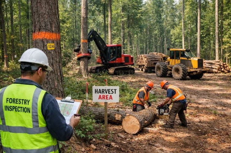
Selective Logging Compliance Verification
Verify sustainable timber management practices with tree-by-tree selective logging detection using very high-resolution satellite imagery (under 70cm) and AI individual tree identification. This service validates harvest plans, monitors FSC and PEFC certification compliance, and tracks high-value species like mahogany, teak, and cedar in timber concessions.
Applied successfully in Peru by OSINFOR for timber concession monitoring, this technology detects individual harvested trees and verifies compliance with approved operational plans (POA). Essential for forest certification bodies, sustainable forestry verification, and preventing over-harvest in selective logging operations across 400 million hectares of tropical forests under management globally.
Key Benefits
- Tree-by-tree selective logging detection
- Verifies FSC and PEFC certification compliance
- Tracks high-value species (mahogany, teak, cedar)
- Applied successfully in Peru timber concessions
- Supports sustainable harvest verification
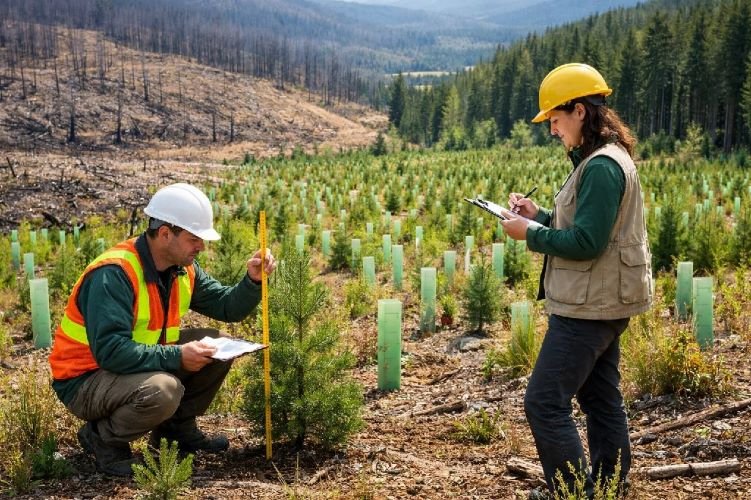
Reforestation & Recovery Monitoring
Verify forest regeneration success and carbon sequestration with time-series monitoring of reforestation projects, natural recovery, and plantation establishment. Using NDVI analysis, growth models, and historical imagery archives dating to 2000s, this service tracks seedling survival rates, vegetation recovery speed, and carbon credit eligibility for REDD+ and voluntary markets.
Essential for carbon credit verification, ESG reporting, and post-harvest regeneration compliance, this monitoring provides objective evidence of restoration success. Applied in corporate reforestation programs, post-fire recovery tracking, and sustainable forestry regeneration verification, enabling forest owners to demonstrate environmental stewardship and access carbon finance opportunities.
Key Benefits
- Tracks seedling survival and vegetation recovery
- Historical archives enable long-term comparison
- Verifies carbon sequestration for credit markets
- Supports REDD+ and voluntary carbon projects
- Provides objective ESG restoration evidence
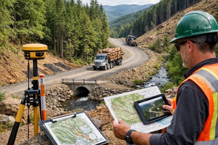
Forest Road Planning & Terrain Analysis
Optimize harvest planning and minimize environmental impact with LiDAR-based terrain analysis for sustainable forest road design. This service generates sub-canopy Digital Terrain Models, slope maps, drainage networks, and accessibility analysis to plan low-impact logging roads, minimize erosion, and ensure equipment safety in challenging forest terrain.
Using airborne LiDAR that penetrates forest canopy to reveal ground topography, this technology identifies optimal road routes, stream crossings, and trafficability constraints. Essential for sustainable forestry technology applications, this analysis reduces road construction costs, minimizes environmental damage, and ensures safe access for timber harvesting equipment across varied forest landscapes.
Key Benefits
- LiDAR reveals sub-canopy ground topography
- Identifies optimal road routes and stream crossings
- Minimizes erosion and environmental impact
- Ensures equipment safety on challenging terrain
- Reduces road construction costs significantly
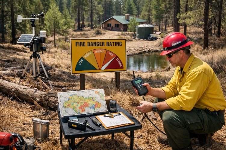
Forest Fire Risk Assessment
Prevent wildfire losses with predictive fire risk assessment using GNSS-R soil moisture monitoring, NDVI vegetation health analysis, and fuel load mapping. This service evaluates fire danger conditions, identifies high-risk ignition zones, and supports strategic fuel reduction planning to protect commercial timber assets and reduce catastrophic fire potential.
Integrating FireSat’s vegetation moisture monitoring with weather data and AI fire danger models, this technology provides actionable intelligence for fire prevention planning. Essential for wildland-urban interface protection, commercial forest risk management, and insurance underwriting, enabling proactive fuel management and defensible space creation before fire season begins.
Key Benefits
- GNSS-R monitors soil and vegetation moisture
- $278 CPC for fire risk assessment keyword
- Fuel load mapping for prevention planning
- Predicts high-risk ignition zones
- Supports strategic fuel reduction activities
Why Choose Satellite-Based Forestry Solutions?
Cost-Effective Operations
Replace expensive ground surveys covering under 1% of forest area with comprehensive satellite monitoring. Reduce inventory costs, optimize harvest planning, and improve timber volume accuracy while enabling individual tree-level precision forestry management.
Enhanced Forest Protection
Early detection of illegal logging, wildfire threats, pest outbreaks, and health issues enables rapid response before significant losses occur. Protect forest value, ensure compliance, and demonstrate sustainable management to certification bodies and stakeholders.
Carbon & ESG Opportunities
Unlock forest carbon revenue through precise biomass measurement and carbon credit verification. Support REDD+, voluntary markets, and corporate ESG reporting with objective satellite-derived evidence of sustainable forestry and reforestation success.
Ready to Transform Your Forestry Operations?
Join leading forestry companies worldwide using satellite technology for forest inventory, wildfire detection, harvest planning, and sustainable timber management to reduce costs, protect assets, and access carbon markets.
Contact Us Today